File:Wv Îles Lavezzi banner.jpg
Size of this preview: 799 × 114 pixels. Other resolutions: 320 × 46 pixels | 640 × 91 pixels | 1,024 × 146 pixels | 5,735 × 819 pixels.
Original file (5,735 × 819 pixels, file size: 1.76 MB, MIME type: image/jpeg)
Captions
Captions
Add a one-line explanation of what this file represents
Summary edit
| Description |
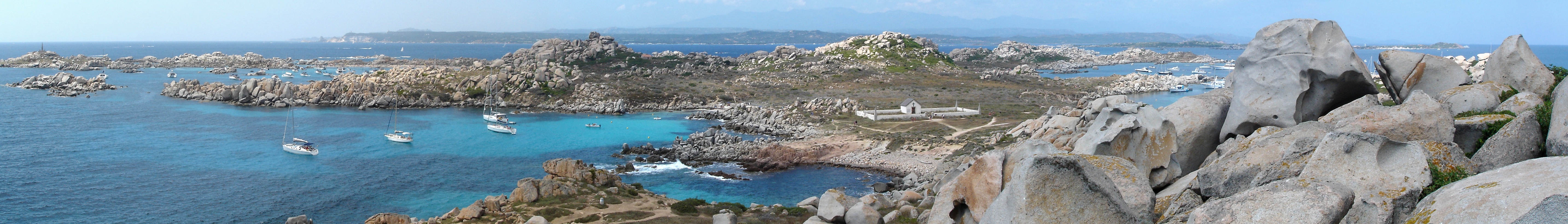
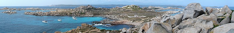
Français : Panorama de Lavezzo, l'île la plus méridionale de l'archipel des Lavezzi, au sud-est de Bonifacio (Corse-du-Sud). C'est aussi la terre la plus au sud de France métropolitaine. On peut voir les falaises de calcaire et le cap Pertusato en arrière-plan, à gauche. Sur la droite se trouve l'île de Cavallo. À travers la brume, on devine au loin la silhouette de la montagne de Cagna. Un des deux cimetières de la Sémillante est visible près du centre de l'image. La pyramide de granite marquant le point de naufrage de la Sémillante se dresse sur la gauche.
English: Panorama of Lavezzo, the southernmost island in the Lavezzi archipelago, southwest of Bonifacio (Corse-du-Sud). This is also the southernmost place of mainland France. The white cliffs of Cape Pertusato are visible on the left. The Cavallo island is visible on the right. The mountain near the top of the picture is the Cagna mountain. The cemetery near the center is one of the two cemeteries where victims of the Sémillante shipwreck were buried. There is also on the left side a granite pyramid dedicated to them. |
| Date | |
| Source | Own work |
| Author | Telperion |
| Other versions |
| Camera location | | View this and other nearby images on: OpenStreetMap |
|---|
Licensing edit
I, the copyright holder of this work, hereby publish it under the following license:
This file is licensed under the Creative Commons Attribution-Share Alike 3.0 Unported license.
- You are free:
- to share – to copy, distribute and transmit the work
- to remix – to adapt the work
- Under the following conditions:
- attribution – You must give appropriate credit, provide a link to the license, and indicate if changes were made. You may do so in any reasonable manner, but not in any way that suggests the licensor endorses you or your use.
- share alike – If you remix, transform, or build upon the material, you must distribute your contributions under the same or compatible license as the original.
| Annotations | This image is annotated: View the annotations at Commons |


File history
Click on a date/time to view the file as it appeared at that time.
| Date/Time | Thumbnail | Dimensions | User | Comment | |
|---|---|---|---|---|---|
| current | 08:54, 14 January 2023 | 5,735 × 819 (1.76 MB) | Teseo (talk | contribs) | File:Îles Lavezzi.jpg cropped < 1 % horizontally, 55 % vertically using CropTool with precise mode. |
You cannot overwrite this file.
File usage on Commons
The following page uses this file:
File usage on other wikis
The following other wikis use this file:
- Usage on it.wikivoyage.org
- Usage on www.wikidata.org