File:Y Gop (Bryn y Saethau), Trelawnyd, Bryniau Clwyd, Sir y Fflint - Gop Hill, Trelawnyd, Flintshire, Moelydd Clwyd (Clwydian Hills), Wales 25.png

Original file (3,840 × 2,160 pixels, file size: 12.73 MB, MIME type: image/png)
Captions
Captions
Summary
edit,_Trelawnyd,_Bryniau_Clwyd,_Sir_y_Fflint_-_Gop_Hill,_Trelawnyd,_Flintshire,_Moelydd_Clwyd_(Clwydian_Hills),_Wales_25.png&action=edit§ion=1)
| Description |
Cymraeg: Y Gop (Bryn y Saethau), trelawnyd, Bryniau Clwyd, Sir Ddinbych.
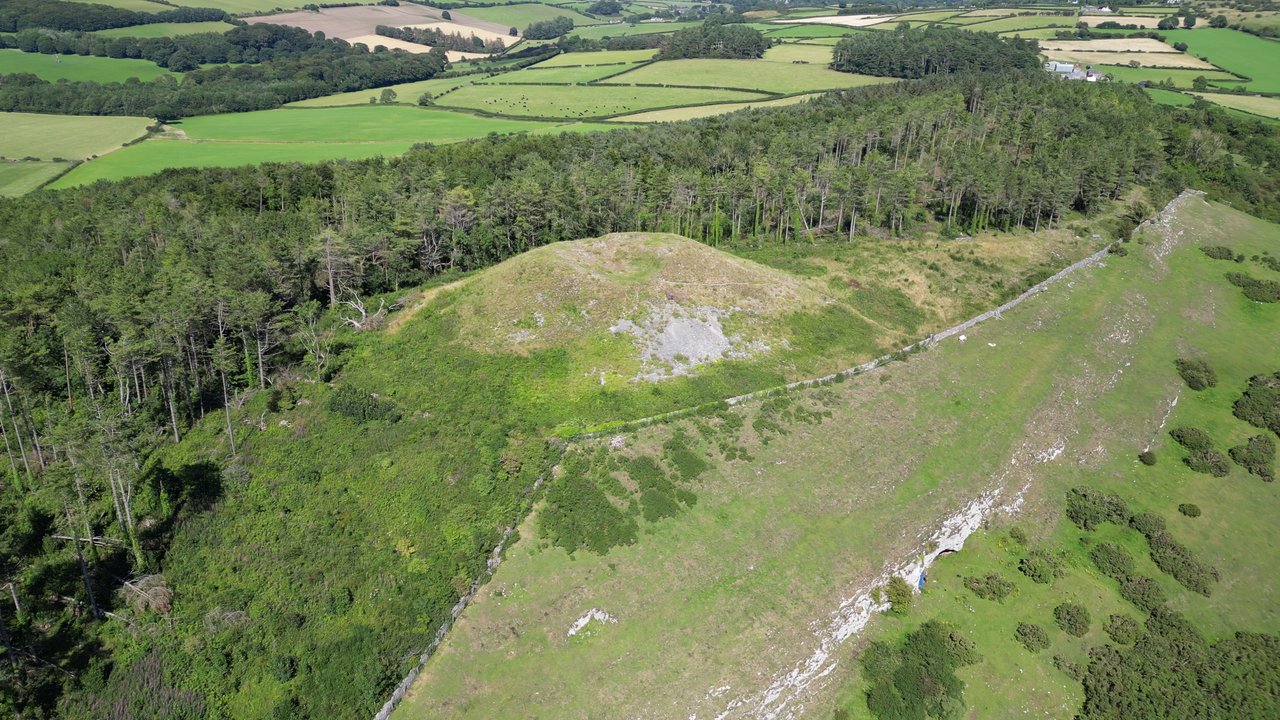
Bryn a safle archaeolegol yn Sir y Fflint yw Y Gop, sy'n dod o'r gair "copa". Fe'i lleolir yng ngogledd-orllewin y sir fymryn i'r gogledd o bentref Trelawnyd, Sir Ddinbych a gellir ei ystyried fel un o gopaon gogleddol Bryniau Clwyd, er ei fod fymryn i'r dwyrain o'r brif gadwyn. Dyma ail siambr gladdu fwyaf gwledydd Prydain - ar ôl Silbury Hill ger Avebury ac mae'n perthyn i Oes Newydd y Cerrig. Cofeb neolithig sy'n gorwedd o fewn Bryniau Clwyd, i'r gogledd-orllewin o Drelawnyd, yn Sir y Fflint, Cymru. AHNE Bryniau Clwyd. Dyma'r twmpath Celtaidd, neolithig ail-fwyaf ym Mhrydain ar ôl Silbury Hill, yn Wiltshire. Mae cloddiadau wedi darganfod olion cynhanesyddol yn yr ogofâu islaw ac yn y twmpath ei hun. Gorwedd y twmpath ar ben Gop Hill (823 troedfedd), brigiad calchfaen naturiol, ac ar ei ochr mae Ogofâu Gop. Mae Ogof y Gop yn y blaendir wedi cynhyrchu sgerbydau dynol, fflintiau cynhanesyddol a chrochenwaith.English: A neolithic monument lying within Bryniau Clwyd (the Clwydian Range), northwest of Trelawnyd, in Flintshire, Wales. Bryniau Clwyd AONB.
It is the second-largest Celtic, neolithic mound in Britain after Silbury Hill, in Wiltshire. Excavations have discovered prehistoric remains both in the caves below and in the mound itself. The mound lies on top of Gop Hill (823 feet), a natural limestone outcrop, in the side of which are the Gop Caves. The Gop Cave in the foreground has produced human skeletons, prehistoric flints and pottery. |
| Date | |
| Source | Own work |
| Author | Llywelyn2000 |
| Camera location | | View this and other nearby images on: OpenStreetMap |
|---|
,_Trelawnyd,_Bryniau_Clwyd,_Sir_y_Fflint_-_Gop_Hill,_Trelawnyd,_Flintshire,_Moelydd_Clwyd_(Clwydian_Hills),_Wales_25.png¶ms=053.310278_N_-003.372222_E_globe:Earth_type:camera__&language=en)
Licensing
edit,_Trelawnyd,_Bryniau_Clwyd,_Sir_y_Fflint_-_Gop_Hill,_Trelawnyd,_Flintshire,_Moelydd_Clwyd_(Clwydian_Hills),_Wales_25.png&action=edit§ion=2)
- You are free:
- to share – to copy, distribute and transmit the work
- to remix – to adapt the work
- Under the following conditions:
- attribution – You must give appropriate credit, provide a link to the license, and indicate if changes were made. You may do so in any reasonable manner, but not in any way that suggests the licensor endorses you or your use.
- share alike – If you remix, transform, or build upon the material, you must distribute your contributions under the same or compatible license as the original.
This image was uploaded as part of Wiki Loves Earth 2023.
|
 |
File history
Click on a date/time to view the file as it appeared at that time.
| Date/Time | Thumbnail | Dimensions | User | Comment | |
|---|---|---|---|---|---|
| current | 20:08, 21 July 2023 | | 3,840 × 2,160 (12.73 MB) | Llywelyn2000 (talk | contribs) | Uploaded own work with UploadWizard |
You cannot overwrite this file.
File usage on Commons
There are no pages that use this file.
File usage on other wikis
The following other wikis use this file:
- Usage on cy.wikipedia.org
,_Trelawnyd,_Bryniau_Clwyd,_Sir_y_Fflint_-_Gop_Hill,_Trelawnyd,_Flintshire,_Moelydd_Clwyd_(Clwydian_Hills),_Wales_25.png&oldid=818681985)