File:Yacimiento arqueológico de Lancia 01 - by smart-drone.es.jpg
No higher resolution available.
Yacimiento_arqueológico_de_Lancia_01_-_by_smart-drone.es.jpg (400 × 201 pixels, file size: 41 KB, MIME type: image/jpeg)
Captions
Captions
Add a one-line explanation of what this file represents
This file was uploaded with Commonist.
Summary edit
| Description |
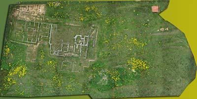
English: Perimetral aerial view of archaeological site of Lancia ancient city, Villasabariego (León, Spain). Picture taken by Smart Drone with a drone. Orthomosaic created with singular images or tiles.
Español: Vista aérea cenital del yacimiento arqueológico de la antigua ciudad de Lancia, Villasabariego (León, España). Foto de Smart Drone tomada con un drone. Ortomosaico formado por imágenes singulares o teselas. |
| Date | 2 May 2015, 18:24:28 (according to Exif data) |
| Source | Taken by Smart Drone, Spain |
| Author | smart-drone.es |
| Permission (Reusing this file) |
| Camera location | | View this and other nearby images on: OpenStreetMap |
|---|
Licensing edit
I, the copyright holder of this work, hereby publish it under the following licenses:

|
Permission is granted to copy, distribute and/or modify this document under the terms of the GNU Free Documentation License, Version 1.2 or any later version published by the Free Software Foundation; with no Invariant Sections, no Front-Cover Texts, and no Back-Cover Texts. A copy of the license is included in the section entitled GNU Free Documentation License. |
This file is licensed under the Creative Commons Attribution 4.0 International license.
- You are free:
- to share – to copy, distribute and transmit the work
- to remix – to adapt the work
- Under the following conditions:
- attribution – You must give appropriate credit, provide a link to the license, and indicate if changes were made. You may do so in any reasonable manner, but not in any way that suggests the licensor endorses you or your use.
You may select the license of your choice.
File history
Click on a date/time to view the file as it appeared at that time.
| Date/Time | Thumbnail | Dimensions | User | Comment | |
|---|---|---|---|---|---|
| current | 19:31, 8 February 2021 | | 400 × 201 (41 KB) | Cookie (talk | contribs) | Reverted to version as of 16:34, 22 May 2015 (UTC) |
| 16:34, 22 May 2015 |  | 400 × 201 (41 KB) | David Perez (talk | contribs) |
You cannot overwrite this file.
File usage on Commons
The following page uses this file: