File:Ye mapha.GIF

Size of this preview: 800 × 481 pixels. Other resolutions: 320 × 192 pixels | 640 × 385 pixels | 943 × 567 pixels.
Original file (943 × 567 pixels, file size: 14 KB, MIME type: image/gif)
Captions
Captions
Add a one-line explanation of what this file represents
Summary
edit
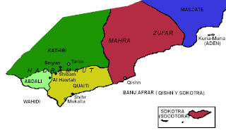
| Description | This self-created map by uploader shows drastically different borders than those seen on the other maps of the Eastern Protectorate. |
| Date | |
| Source | Original work of uploader |
| Author | Jaume Ollé i Casals |
Licensing
edit
This file is licensed under the Creative Commons Attribution 3.0 Unported license.
- You are free:
- to share – to copy, distribute and transmit the work
- to remix – to adapt the work
- Under the following conditions:
- attribution – You must give appropriate credit, provide a link to the license, and indicate if changes were made. You may do so in any reasonable manner, but not in any way that suggests the licensor endorses you or your use.
File history
Click on a date/time to view the file as it appeared at that time.
| Date/Time | Thumbnail | Dimensions | User | Comment | |
|---|---|---|---|---|---|
| current | 23:46, 16 November 2007 | | 943 × 567 (14 KB) | Jolle~commonswiki (talk | contribs) | {{Information |Description=Map of Eastern Aden Protectorate |Source= |Date=2000 |Author= Jaume Ollé i Casals |Permission=see below |other_versions= }} |
You cannot overwrite this file.
File usage on Commons
There are no pages that use this file.
File usage on other wikis
The following other wikis use this file:
- Usage on ar.wikipedia.org
- Usage on ca.wikipedia.org
- Usage on es.wikipedia.org
- Usage on nl.wikipedia.org
- Usage on ru.wikipedia.org
- Usage on uz.wikipedia.org