File:Yongshu Jiao to Yongdeng Ansha (South China Sea) NGA Nautical Chart 93044.jpg

Size of this preview: 800 × 566 pixels. Other resolutions: 320 × 226 pixels | 640 × 452 pixels | 1,024 × 724 pixels | 1,280 × 905 pixels | 2,560 × 1,810 pixels | 23,200 × 16,400 pixels.
Original file (23,200 × 16,400 pixels, file size: 9.61 MB, MIME type: image/jpeg)
Captions
Captions
Add a one-line explanation of what this file represents
Summary edit
_NGA_Nautical_Chart_93044.jpg&action=edit§ion=1)
| Warning | The original file is very high-resolution. It might not load properly or could cause your browser to freeze when opened at full size. |
|---|
| Description |
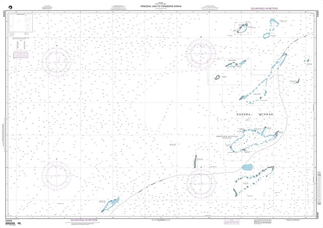
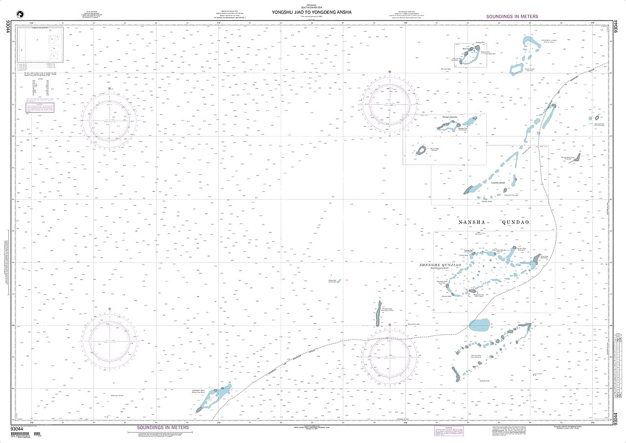
English: Nautical chart of the South China Sea: North Danger Reef, Trident Shoal, Lys Shoal, Thitu Island, Subi Reef, West York Island, Irving Reef, Loaita Bank, Southampton Reefs (Tizard Bank), Discovery Great Reef, Union Tablemount (Union Reefs), Fiery Cross Reef |
| Date | |
| Source | http://www.oceangrafix.com |
| Author | National Geospatial-Intelligence Agency |
Licensing edit
_NGA_Nautical_Chart_93044.jpg&action=edit§ion=2)
This work is in the public domain in the United States because it is a work prepared by an officer or employee of the United States Government as part of that person’s official duties under the terms of Title 17, Chapter 1, Section 105 of the US Code.
Note: This only applies to original works of the Federal Government and not to the work of any individual U.S. state, territory, commonwealth, county, municipality, or any other subdivision. This template also does not apply to postage stamp designs published by the United States Postal Service since 1978. (See § 313.6(C)(1) of Compendium of U.S. Copyright Office Practices). It also does not apply to certain US coins; see The US Mint Terms of Use.
|
 | |
| This file has been identified as being free of known restrictions under copyright law, including all related and neighboring rights. | ||
File history
Click on a date/time to view the file as it appeared at that time.
| Date/Time | Thumbnail | Dimensions | User | Comment | |
|---|---|---|---|---|---|
| current | 13:21, 11 May 2018 | | 23,200 × 16,400 (9.61 MB) | Pemu (talk | contribs) | Greater resolution |
| 12:49, 9 May 2018 |  | 300 × 211 (10 KB) | Ratzer (talk | contribs) | User created page with UploadWizard |
You cannot overwrite this file.
File usage on Commons
There are no pages that use this file.
File usage on other wikis
The following other wikis use this file:
- Usage on de.wikipedia.org
_NGA_Nautical_Chart_93044.jpg&oldid=746746178)