File:Yozadake sites.png
Size of this preview: 620 × 599 pixels. Other resolutions: 248 × 240 pixels | 497 × 480 pixels | 749 × 724 pixels.
Original file (749 × 724 pixels, file size: 555 KB, MIME type: image/png)
Captions
Captions
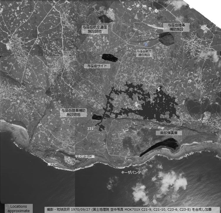
Yozadake sites
Summary
edit
| Description |
English: Yozadake sites |
| Date | |
| Source | 国土地理院地図・空中写真閲覧サービス (撮影・琉球政府 1970/09/27 国土地理院 空中写真 MOK701X C21-9, C21-10, C23-6, C23-8 を合成し加筆 ) |
| Author | 琉球政府 |
Licensing
edit

|
This work is licensed under the Government of Japan Standard Terms of Use (Ver.2.0). The Terms of Use are compatible with the Creative Commons Attribution License 4.0 International. For the terms of use of this work, see this license page.
|
This file is licensed under the Creative Commons Attribution 4.0 International license.
Attribution: 国土地理院 (GSI)
- You are free:
- to share – to copy, distribute and transmit the work
- to remix – to adapt the work
- Under the following conditions:
- attribution – You must give appropriate credit, provide a link to the license, and indicate if changes were made. You may do so in any reasonable manner, but not in any way that suggests the licensor endorses you or your use.
File history
Click on a date/time to view the file as it appeared at that time.
| Date/Time | Thumbnail | Dimensions | User | Comment | |
|---|---|---|---|---|---|
| current | 02:58, 1 March 2022 | | 749 × 724 (555 KB) | Alain Parks (talk | contribs) | Uploaded a work by 琉球政府 from 国土地理院地図・空中写真閲覧サービス (撮影・琉球政府 1970/09/27 国土地理院 空中写真 MOK701X C21-9, C21-10, C23-6, C23-8 を合成し加筆 ) with UploadWizard |
You cannot overwrite this file.
File usage on Commons
There are no pages that use this file.