File:Yuma arizona map.jpg

Size of this preview: 406 × 599 pixels. Other resolutions: 162 × 240 pixels | 576 × 850 pixels.
Original file (576 × 850 pixels, file size: 57 KB, MIME type: image/jpeg)
Captions
Captions
Add a one-line explanation of what this file represents
| Description |
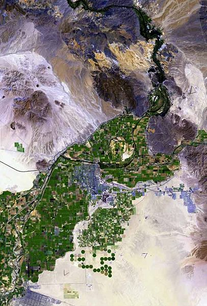
The raw satellite imagery shown in these images was obtained from NASA and/or the US Geological Survey. Post-processing and production by http://www.terraprints.com The en:Colorado River is the border between California, (top, and left), and Arizona, (bottom, and right). The en:Yuma Desert is shown quite prominently, south of Yuma, and the Fortuna Foothills, at the west of the en:Gila Mountains (Yuma County). The Yuma Desert is at the northwest of the Picacho Volcanic field complex, and the great: Gran Desierto de Altar, of north and northwest, Sonora state Mexico. (Note the en:Alluvial fans, especially around the Cargo Muchacho Mountains of California, but throughout the photo.) |
| Date | |
| Source | http://www.terraprints.com |
| Author | http://www.terraprints.com |
This file is licensed under the Creative Commons Attribution 2.5 Generic license.
- You are free:
- to share – to copy, distribute and transmit the work
- to remix – to adapt the work
- Under the following conditions:
- attribution – You must give appropriate credit, provide a link to the license, and indicate if changes were made. You may do so in any reasonable manner, but not in any way that suggests the licensor endorses you or your use.
| Annotations | This image is annotated: View the annotations at Commons |
File history
Click on a date/time to view the file as it appeared at that time.
| Date/Time | Thumbnail | Dimensions | User | Comment | |
|---|---|---|---|---|---|
| current | 17:49, 25 September 2007 | | 576 × 850 (57 KB) | Marku1988 (talk | contribs) | |
| 18:52, 25 October 2006 |  | 671 × 1,000 (67 KB) | Terraprints (talk | contribs) | {{Information |Description=The raw satellite imagery shown in these images was obtain from NASA and/or the US Geological Survey. Post-processing and production by http://www.terraprints.com |Source=http://www.terraprints.com |Date=20061025 |Author=http:// |
You cannot overwrite this file.
File usage on Commons
The following 4 pages use this file:
File usage on other wikis
The following other wikis use this file:
- Usage on arz.wikipedia.org
- Usage on ceb.wikipedia.org
- Usage on en.wikipedia.org
- Usage on es.wikipedia.org
- Usage on fr.wikipedia.org
- Usage on fy.wikipedia.org
- Usage on he.wikipedia.org
- Usage on ja.wikipedia.org
- Usage on lld.wikipedia.org
- Usage on nn.wikipedia.org
- Usage on www.wikidata.org
- Usage on zh.wikipedia.org