File:Zakarpattia regions.svg

Size of this PNG preview of this SVG file: 800 × 394 pixels. Other resolutions: 320 × 158 pixels | 640 × 315 pixels | 1,024 × 504 pixels | 1,280 × 630 pixels | 2,560 × 1,260 pixels | 904 × 445 pixels.
Original file (SVG file, nominally 904 × 445 pixels, file size: 348 KB)
Captions
Captions
Add a one-line explanation of what this file represents
| Description |
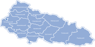
Українська: Карта-схема районів Закарпатської області |
| Date | |
| Source | Own work |
| Author | Катерина Ткачова (Користувач:Kaha) |
| Permission (Reusing this file) |
This file is licensed under the Creative Commons Attribution-Share Alike 3.0 Unported license.
|
Original upload log
edit
The original description page was here. All following user names refer to uk.wikipedia.
- 2012-06-04 16:17 Texnik 904×445× (356556 bytes) {{Зображення|Назва=Zakarpattia_regions.svg|Опис=Карта-схема районів Закарпатської області|Автор=власна робота заснована на роботі Катерини Ткачов...
- 2009-01-20 11:25 VictorAnyakin 904×445× (395047 bytes) {{Зображення|Назва=Zakarpattia_regions.svg|Опис=Карта-схема районів Закарпатської області|Автор=Катерина Ткачова ([[Користувач:Kaha]])|Джерело=власна р
File history
Click on a date/time to view the file as it appeared at that time.
| Date/Time | Thumbnail | Dimensions | User | Comment | |
|---|---|---|---|---|---|
| current | 12:03, 25 January 2013 | | 904 × 445 (348 KB) | BaseBot (talk | contribs) | automatted transfer from ukwikip using BaseSat's program |
You cannot overwrite this file.
File usage on Commons
There are no pages that use this file.
File usage on other wikis
The following other wikis use this file:
- Usage on ba.wikipedia.org
- Usage on bg.wikipedia.org
- Usage on en.wikipedia.org
- Usage on pl.wikipedia.org
- Usage on ru.wikipedia.org
- Usage on uk.wikipedia.org
- Підкарпатська Русь
- Обговорення:Верхньотисинська улоговина
- Обговорення:Берегуйфалу
- Обговорення:Мужієво
- Обговорення:Сойми
- Обговорення:Шом (Берегівський район)
- Шаблон:Zakarpattya-week-new
- Обговорення:Малий Березний (пункт контролю)
- Обговорення:Автошлях Р 53
- Шаблон:Zakarpattya-week-improve
- Обговорення:Герб Міжгірського району
- Обговорення:Сойминська (мінеральна вода)
- Обговорення:Лужанка (пункт контролю)
- Обговорення:Автошлях М 24
- Обговорення:Вакаров Дмитро Онуфрійович
- Обговорення:Вилок (пункт контролю)
- Обговорення:Дякове (пункт контролю)
- Обговорення:Автошлях М 26
- Обговорення:Ділове (пункт контролю)
- Обговорення:Парк санаторію «Карпати»
- Обговорення:Солотвино (пункт контролю)
- Обговорення:Герб Берегівського району
- Обговорення:Герб Виноградівського району
- Обговорення:Берегуйфалівська сільська рада
- Обговорення:Тересва (пункт контролю)
- Обговорення:Малі Селменці (пункт контролю)
- Обговорення:Історія Мукачева
- Обговорення:Павлове (пункт контролю)
- Обговорення:Чоп (Страж)
- Обговорення:Ілона Зріні
- Обговорення:Батьово
- Обговорення:Жденівка
- Обговорення:Гукливський літопис
- Обговорення:Мостовий Руслан Іванович
- Обговорення:Високий Камінь (пам'ятка природи)
- Обговорення:Великий Яворець та Обнога
- Обговорення:Батєве
- Обговорення:Дзвінкове (пункт контролю)
- Обговорення:Косино (пункт контролю)
- Обговорення:Соловка (пункт контролю)
- Обговорення:Росішний (заказник)
- Обговорення:Чоп (пункт контролю)
- Обговорення:Уг
- Обговорення:Тур'я (притока Ужа)
- Обговорення:Керничний заказник
View more global usage of this file.