File:Zamhlay Panorama.jpg

Size of this preview: 799 × 250 pixels. Other resolutions: 320 × 100 pixels | 640 × 200 pixels | 1,024 × 320 pixels | 1,280 × 401 pixels | 3,397 × 1,063 pixels.
Original file (3,397 × 1,063 pixels, file size: 735 KB, MIME type: image/jpeg)
Captions
Captions
Add a one-line explanation of what this file represents
Summary
edit
| Description |
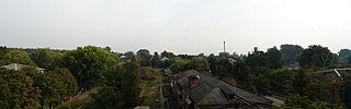
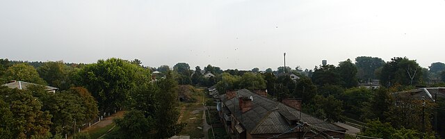
Українська: Панорама смт Замглай, Чернігівська область English: Panorama of Zamhlay, Chernihiv Oblast, Ukraine |
| Date | |
| Source | Замглай |
| Author | R_Kurak |
| Camera location | | View this and other nearby images on: OpenStreetMap |
|---|
Licensing
edit
This file is licensed under the Creative Commons Attribution-Share Alike 3.0 Unported license.
- You are free:
- to share – to copy, distribute and transmit the work
- to remix – to adapt the work
- Under the following conditions:
- attribution – You must give appropriate credit, provide a link to the license, and indicate if changes were made. You may do so in any reasonable manner, but not in any way that suggests the licensor endorses you or your use.
- share alike – If you remix, transform, or build upon the material, you must distribute your contributions under the same or compatible license as the original.
| This image, which was originally posted to Panoramio, was reviewed on 8 February 2011 by the administrator or trusted user Lymantria, who confirmed that it was available on Panoramio under the above license on that date. |
File history
Click on a date/time to view the file as it appeared at that time.
| Date/Time | Thumbnail | Dimensions | User | Comment | |
|---|---|---|---|---|---|
| current | 21:51, 7 February 2011 | 3,397 × 1,063 (735 KB) | NickK (talk | contribs) | {{Information |Description={{uk|1=Панорама смт uk:Замглай (смт), Чернігівська область}}{{en|1=Panorama of en:Zamhlay, Chernihiv Oblast, Ukraine}} |Source=[http://www.panoramio.com/photo/30576405 Замг |
You cannot overwrite this file.
File usage on Commons
The following page uses this file:
File usage on other wikis
The following other wikis use this file:
- Usage on be.wikipedia.org
- Usage on ce.wikipedia.org
- Usage on crh.wikipedia.org
- Usage on de.wikipedia.org
- Usage on fi.wikipedia.org
- Usage on fr.wikipedia.org
- Usage on hy.wikipedia.org
- Usage on mhr.wikipedia.org
- Usage on pl.wikipedia.org
- Usage on ro.wikipedia.org
- Usage on ru.wikipedia.org
- Usage on sah.wikipedia.org
- Usage on uk.wikipedia.org
- Usage on uz.wikipedia.org
- Usage on www.wikidata.org
- Usage on zh.wikipedia.org