File:Zawady (gmina) location map.png

Size of this preview: 597 × 600 pixels. Other resolutions: 239 × 240 pixels | 478 × 480 pixels | 802 × 806 pixels.
Original file (802 × 806 pixels, file size: 171 KB, MIME type: image/png)
Captions
Captions
Add a one-line explanation of what this file represents
| Description |
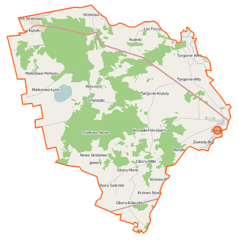
Polski: Mapa gminy Zawady, Polska
English: Map of Gmina Zawady, Poland |
|||||||||
| Date | ||||||||||
| Source | You may find a page on the OpenStreetMap wiki page for Zawady (gmina) | |||||||||
| Creator |
OpenStreetMap contributors OpenStreetMap contributors |
|||||||||
| Permission (Reusing this file) |
OpenStreetMap data is available under the Open Database License (details). Map tiles are licensed under the Creative Commons Attribution-ShareAlike 2.0 license (CC-BY-SA 2.0).
This file is licensed under the Creative Commons Attribution-Share Alike 2.0 Generic license.
|
|||||||||
| Geotemporal data | ||||||||||
| Bounding box |
|
|||||||||
| Georeferencing | If inappropriate please set warp_status = skip to hide. | |||||||||
File history
Click on a date/time to view the file as it appeared at that time.
| Date/Time | Thumbnail | Dimensions | User | Comment | |
|---|---|---|---|---|---|
| current | 08:09, 16 September 2014 | | 802 × 806 (171 KB) | VanWiel (talk | contribs) | {{Information |Description= |Source= |Date= |Author= |Permission= |other_versions= }} |
| 08:02, 5 June 2014 |  | 802 × 806 (178 KB) | VanWiel (talk | contribs) | {{OpenStreetMap | name = Zawady (gmina) | location = Zawady (gmina) | description = {{pl|Mapa gminy Zawady, Polska}} {{en|Map of Gmina Zawady, Poland}} | top = 53.2229 | left = 22.4626 | right... |
You cannot overwrite this file.
File usage on Commons
There are no pages that use this file.
File usage on other wikis
The following other wikis use this file:
- Usage on pl.wikipedia.org
- Zawady (gmina)
- Cibory-Chrzczony
- Cibory Gałeckie
- Cibory-Kołaczki
- Cibory-Krupy
- Cibory-Marki
- Cibory-Witki
- Góra Strękowa
- Krzewo-Plebanki
- Kurpiki
- Konopki-Pokrzywnica
- Konopki-Klimki
- Łaś-Toczyłowo
- Maliszewo-Łynki
- Maliszewo-Perkusy
- Nowe Chlebiotki
- Nowe Grabowo
- Stare Chlebiotki
- Stare Grabowo
- Stare Krzewo
- Strękowa Góra
- Targonie-Krytuły
- Targonie Wielkie
- Targonie-Wity
- Wieczorki
- Zawady-Borysówka
- Zawady-Kolonia
- Nowe Krzewo (powiat białostocki)
- Rudniki (powiat białostocki)
- Zawady (gmina Zawady)
- Marylki (województwo podlaskie)
- Parafia Przemienienia Pańskiego w Zawadach Kościelnych
- Parafia św. Antoniego Padewskiego w Nowych Chlebiotkach
- Kościół Przemienienia Pańskiego w Zawadach Kościelnych
- Moduł:Mapa/dane/Zawady (gmina)
- Olszyna-Grab
- Rudniki Małe
- Usage on pl.wikibooks.org
_location_map.png&oldid=475907947)