File:Zebulon Pike Map.PNG

Size of this preview: 535 × 600 pixels. Other resolutions: 214 × 240 pixels | 428 × 480 pixels | 685 × 768 pixels | 1,221 × 1,369 pixels.
Original file (1,221 × 1,369 pixels, file size: 3.27 MB, MIME type: image/png)
Captions
Captions
Add a one-line explanation of what this file represents
Summary
edit
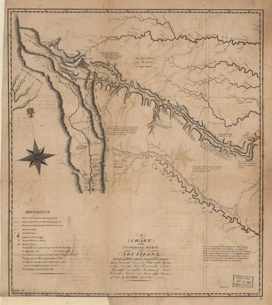
Zebulon Pike's Expedition (1806-1807) : A Chart of the Internal Part of Louisiana from An Account of Expeditions to the Sources of the Mississippi and through the Western Parts of Louisiana . . . . Philadelphia: C. & A. Conrad, 1810
From: A Chart of the Internal Part of Louisiana The Library of Congress
Licensing
edit
| This work is from the Library of Congress. According to the library, there are no known copyright restrictions on the use of this work. |  |
File history
Click on a date/time to view the file as it appeared at that time.
| Date/Time | Thumbnail | Dimensions | User | Comment | |
|---|---|---|---|---|---|
| current | 07:31, 7 June 2007 | | 1,221 × 1,369 (3.27 MB) | SalomonCeb (talk | contribs) | '''Zebulon Pike's Expedition''' (1806-1807) : '' A Chart of the Internal Part of Louisiana'' from An Account of Expeditions to the Sources of the Mississippi and through the Western Parts of Louisiana . . . . Philadelphia: C. & A. Conrad, 1810 From: [htt |
You cannot overwrite this file.
File usage on Commons
The following page uses this file:
File usage on other wikis
The following other wikis use this file:
- Usage on en.wikipedia.org
- Usage on es.wikipedia.org
- Usage on fr.wikipedia.org
- Usage on ru.wikipedia.org
- Usage on www.wikidata.org