File:Zeisigwaldkarte.png

Size of this preview: 663 × 600 pixels. Other resolutions: 265 × 240 pixels | 530 × 480 pixels | 849 × 768 pixels | 1,132 × 1,024 pixels | 1,736 × 1,571 pixels.
Original file (1,736 × 1,571 pixels, file size: 2.1 MB, MIME type: image/png)
Captions
Captions
Add a one-line explanation of what this file represents
Summary
edit
| Description |
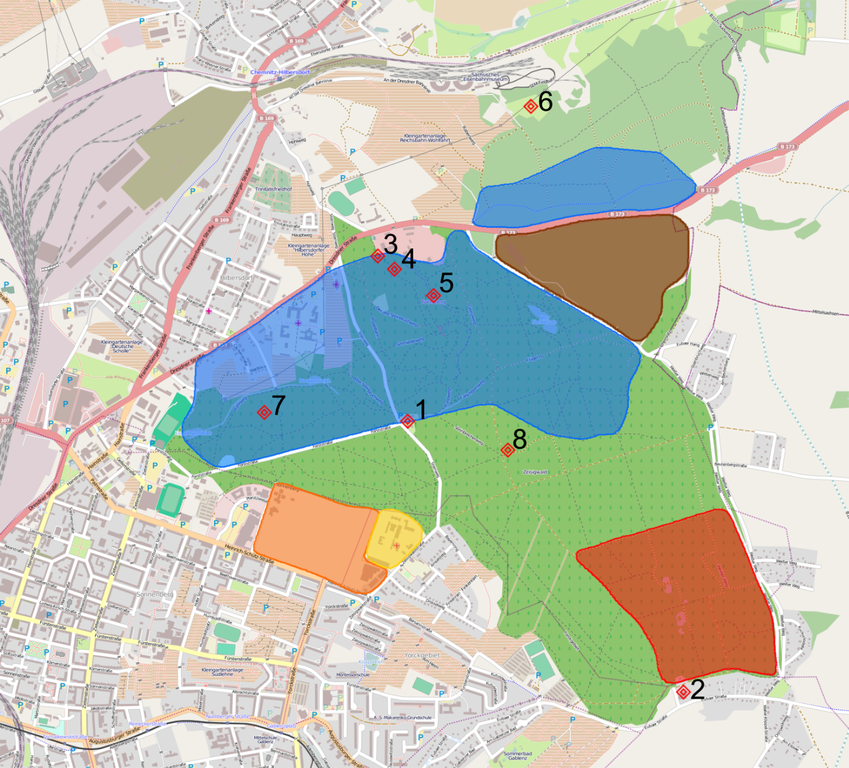
Deutsch: Übersichtskarte des Zeisigwaldes Blau: ehemalige Steinbrüche Rot: ehemaliges Tanklager Braun: Deponie Weißer Weg Orange: Ehemalige Kaserne Gelb: Zeisigwaldkliniken Bethanien 1: Zeisigwaldschänke 2: Heideschänke 3: Porphyrhaus 4: Teufelsbrücken 5: Fuchsberg 6: ehemaliges Reichsbahnbad 7: ehemaliges Zeisigwaldbad 8: Denkmal für das 15. Königlich Sächsische Infanterie-Regiment |
| Date | |
| Source | Karte von Openstreetmap.org, Bearbeitung von Lord van Tasm |
| Author |
Openstreetmap.org, Lord van Tasm. Lord van Tasm at German Wikipedia |
Licensing
edit
This file is licensed under the Creative Commons Attribution-Share Alike 2.0 Germany license.
- You are free:
- to share – to copy, distribute and transmit the work
- to remix – to adapt the work
- Under the following conditions:
- attribution – You must give appropriate credit, provide a link to the license, and indicate if changes were made. You may do so in any reasonable manner, but not in any way that suggests the licensor endorses you or your use.
- share alike – If you remix, transform, or build upon the material, you must distribute your contributions under the same or compatible license as the original.

| This work contains information from OpenStreetMap, which is made available under the Open Database License (ODbL).
The ODbL does not require any particular license for maps produced from ODbL data. Prior to 1 August 2020, map tiles produced by the OpenStreetMap Foundation were licensed under the CC-BY-SA-2.0 license. Maps produced by other people may be subject to other licences. |
Original upload log
edit
The original description page was here. All following user names refer to de.wikipedia.
| Date/Time | Dimensions | User | Comment |
|---|---|---|---|
| 2013-04-22 18:27 | 1736×1571× (2200339 bytes) | Lord van Tasm | {{Information |Beschreibung = Übersichtskarte des [[Zeisigwald]]es |Quelle = Karte von Openstreetmap.org, Bearbeitung von [[Benutzer:Lord van Tasm|Lord van Tasm]] |Urheber = [[Benutzer:Lord van Tasm|Lord van Tasm]] |Datum … |
File history
Click on a date/time to view the file as it appeared at that time.
| Date/Time | Thumbnail | Dimensions | User | Comment | |
|---|---|---|---|---|---|
| current | 10:58, 28 August 2014 | | 1,736 × 1,571 (2.1 MB) | Nachcommonsverschieber (talk | contribs) | Transferred from de.wikipedia |
You cannot overwrite this file.
File usage on Commons
There are no pages that use this file.
File usage on other wikis
The following other wikis use this file:
- Usage on de.wikipedia.org