File:Zhou occidentaux etats.svg

Size of this PNG preview of this SVG file: 568 × 384 pixels. Other resolutions: 320 × 216 pixels | 640 × 433 pixels | 1,024 × 692 pixels | 1,280 × 865 pixels | 2,560 × 1,731 pixels.
Original file (SVG file, nominally 568 × 384 pixels, file size: 712 KB)
Captions
Captions
Add a one-line explanation of what this file represents
Summary edit
| Description |
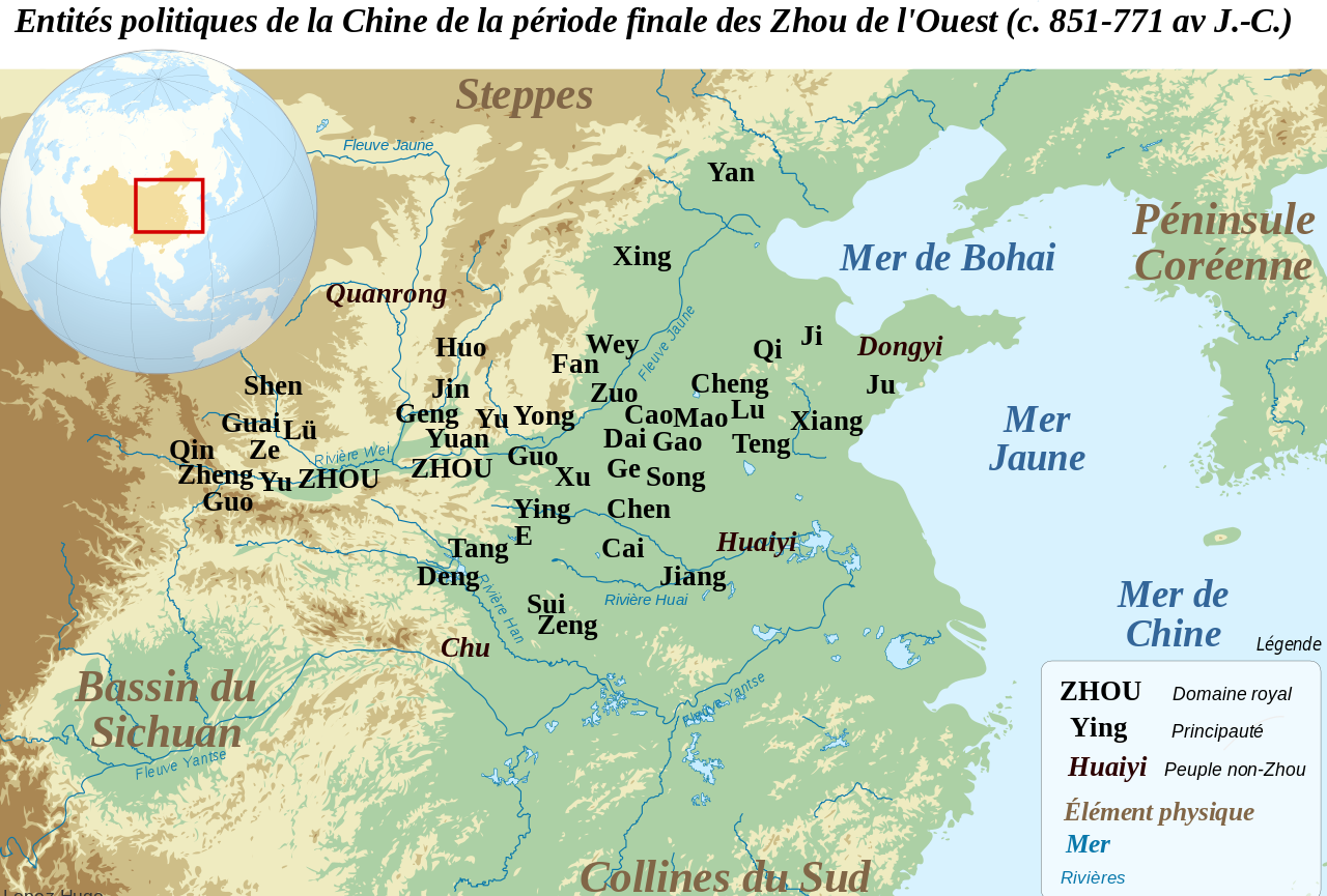
Français : Carte de localisation des principales entités politiques de la Chine du Nord durant la période finale des Zhou de l'Ouest (c. 851-771 av. J.-C. Les localisations des principautés sont souvent approximatives, et reposent sur les propositions et cartes de F. Li, Landscape and Power in Early China, The Crisis and Fall of the Western Zhou 1045-771 BC, New York, 2006. Les principautés de l'Ouest (Zheng, Guo, Shen, Lü et Qin) sont localisées avant leurs migrations vers l'est. English: Location map of the main political actors of the Late Western Zhou Period (c. 851-771 BC). Many of the locations given are only approximate, and based on the conclusions and maps of F. Li, Landscape and Power in Early China, The Crisis and Fall of the Western Zhou 1045-771 BC, New York, 2006. Western states such as Zheng, Guo, Shen, Lü and Qin are located before their eastward migrations. |
| Date | |
| Source |
This file was derived from: Chinese plain 5c. BC-fr.svg: |
| Author |
|
| This is a retouched picture, which means that it has been digitally altered from its original version. Modifications: suppression frontières, ajout des états. The original can be viewed here: Chinese plain 5c. BC-fr.svg:
|
Licensing edit
I, the copyright holder of this work, hereby publish it under the following license:
This file is licensed under the Creative Commons Attribution-Share Alike 3.0 Unported license.
- You are free:
- to share – to copy, distribute and transmit the work
- to remix – to adapt the work
- Under the following conditions:
- attribution – You must give appropriate credit, provide a link to the license, and indicate if changes were made. You may do so in any reasonable manner, but not in any way that suggests the licensor endorses you or your use.
- share alike – If you remix, transform, or build upon the material, you must distribute your contributions under the same or compatible license as the original.
Original upload log edit
This image is a derivative work of the following images:
- File:Chinese_plain_5c._BC-fr.svg licensed with Cc-by-sa-3.0
Uploaded with derivativeFX
File history
Click on a date/time to view the file as it appeared at that time.
| Date/Time | Thumbnail | Dimensions | User | Comment | |
|---|---|---|---|---|---|
| current | 15:52, 6 August 2012 | | 568 × 384 (712 KB) | Zunkir (talk | contribs) | Nouvel essai. |
| 15:50, 6 August 2012 |  | 568 × 384 (712 KB) | Zunkir (talk | contribs) | Reverted to version as of 15:46, 6 August 2012 | |
| 15:49, 6 August 2012 |  | 568 × 384 (712 KB) | Zunkir (talk | contribs) | Reverted to version as of 09:20, 6 August 2012 | |
| 15:46, 6 August 2012 |  | 568 × 384 (712 KB) | Zunkir (talk | contribs) | Nouvel essai. | |
| 09:20, 6 August 2012 |  | 568 × 384 (712 KB) | Zunkir (talk | contribs) | Modif localisation des Quanrong. | |
| 09:56, 30 April 2012 |  | 568 × 384 (712 KB) | Zunkir (talk | contribs) | == {{int:filedesc}} == {{Information |Description={{fr|1=Carte de localisation des principales entités politiques de la Chine du Nord durant la période finale des Zhou de l'Ouest (c. 851-771 av. J.-C. Les localisations des principautés sont souvent ... |
You cannot overwrite this file.
File usage on Commons
There are no pages that use this file.
File usage on other wikis
The following other wikis use this file:
- Usage on en.wikipedia.org
- Usage on fr.wikipedia.org
- Usage on it.wikipedia.org
- Usage on ja.wikipedia.org
- Usage on pl.wikipedia.org
- Usage on ru.wikipedia.org
- Usage on sv.wikipedia.org