File:Zwiefalten Abbey.png

No higher resolution available.
Zwiefalten_Abbey.png (313 × 432 pixels, file size: 294 KB, MIME type: image/png)
Captions
Captions
Add a one-line explanation of what this file represents
Summary edit
| Description |
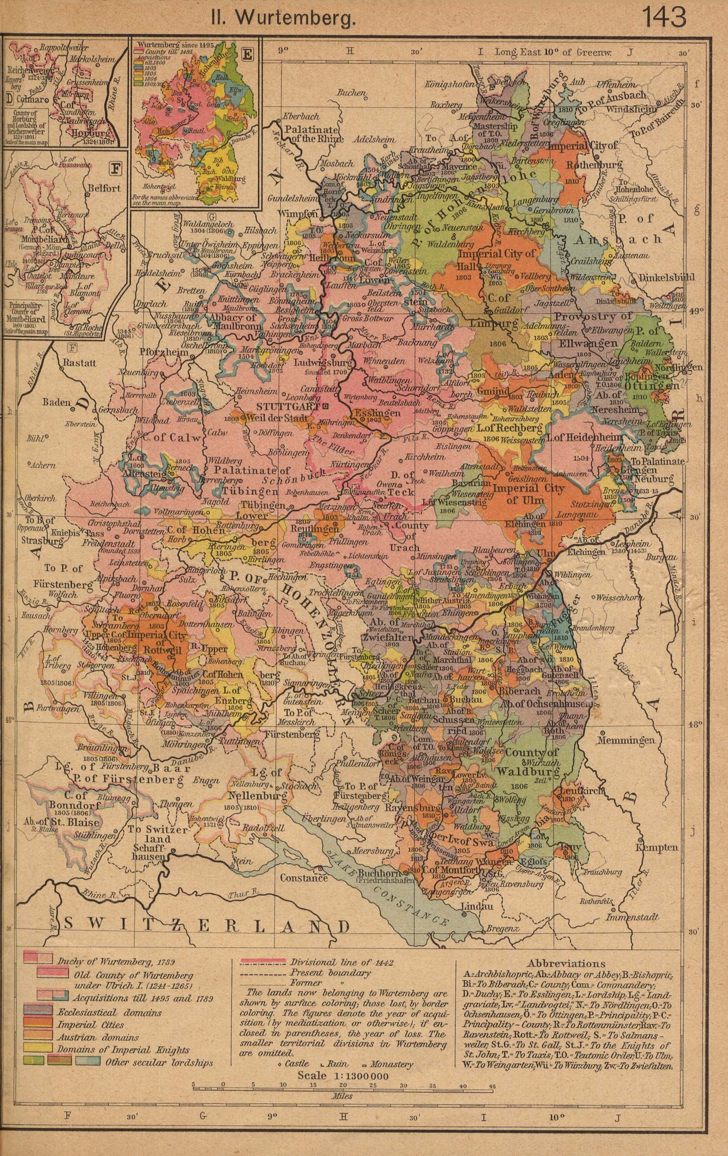
English: Zwiefalten Abbey, shown with the River Danube running across the frame, 9°30′E running vertically, 48°N at the bottom of the frame and 48°30′N at the top. |
||||||||||||||||||||||
| Date | |||||||||||||||||||||||
| Source | Cropped from German States Before and since the French Revolution: II. Wurtemberg (698K). From The Historical Atlas by William R. Shepherd, 1923. | ||||||||||||||||||||||
| Author |
|
||||||||||||||||||||||
Licensing edit
This work is in the public domain because it was published in the United States between 1929 and 1963, and although there may or may not have been a copyright notice, the copyright was not renewed. For further explanation, see Commons:Hirtle chart and the copyright renewal logs. Note that it may still be copyrighted in jurisdictions that do not apply the rule of the shorter term for US works (depending on the date of the author's death), such as Canada (70 years p.m.a.), Mainland China (50 years p.m.a., not Hong Kong or Macao), Germany (70 years p.m.a.), Mexico (100 years p.m.a.), Switzerland (70 years p.m.a.), and other countries with individual treaties.
|
 |
The author died in 1934, so this work is in the public domain in its country of origin and other countries and areas where the copyright term is the author's life plus 80 years or fewer. | |
| This file has been identified as being free of known restrictions under copyright law, including all related and neighboring rights. | |
Original upload log edit
Transferred from en.wikipedia to Commons by Fredlyfish4 using CommonsHelper.
The original description page was here. All following user names refer to en.wikipedia.
- 2007-07-15 16:40 OwenBlacker 313×432× (300664 bytes) Cropped from [http://www.lib.utexas.edu/maps/historical/shepherd/german2_shepherd.jpg German States Before and since the French Revolution: II. Wurtemberg] (698K). From The Historical Atlas by William R. Shepherd, 1923.
File history
Click on a date/time to view the file as it appeared at that time.
| Date/Time | Thumbnail | Dimensions | User | Comment | |
|---|---|---|---|---|---|
| current | 15:05, 28 October 2012 | | 313 × 432 (294 KB) | File Upload Bot (Magnus Manske) (talk | contribs) | Transfered from en.wikipedia by User:Fredlyfish4 using CommonsHelper |
You cannot overwrite this file.
File usage on Commons
The following page uses this file:
File usage on other wikis
The following other wikis use this file:
- Usage on de.wikipedia.org
- Usage on nl.wikipedia.org
- Usage on www.wikidata.org