File talk:Lenguas celtas.PNG
Brittany edit
Hello, thanks for this map. A nitpick however: why is the North-West of Brittany in pale green, as if Breton were no longer spoken there ? It should rather be in strong green like the rest of Lower Brittany. This place is actually the stronghold of w:fr:Breton léonard, a dialect of Breton that had a great importance in the formation of the literary norm.
At least, if I understand correctly the colour code : strong green for areas where modern Celtic languages are still spoken today, light green for their historic expansion, going back to the Middle Ages (it is necessary to go back that far to account for the area ascribed to Cornish). I suggest to legend the map to explain the meaning of the colours.
Revamping and update edit
Hello,
An ID-user had added a precision on the use of the darker and lighter green, pointing toward current and former repartition of Celtic languages. This was certainly in good intent, done according to my quick comment above. Unfortunately, when paying more attention, this was wrong: from similar maps by Fobos92, quite clearly, although implicitly, the pattern is rather intended to be "majority of speakers of a Celtic language" for dark green vs. "minority of speakers of a Celtic language" for light green. Not to mention that the range of Celtic languages changed so much across centuries that it does not make sense to precise a "former range" without giving the precise period : a few centuries before J. C., most of Western and some of Central Europe would need to be included! I have therefore added a legend to make things clear that this map is intended to be synchronic.
I also revised the map according to more precise ones in Commons, based on data from recent linguistic surveys. (Of course the present map is intended to only general and rough, just to get an idea.)
-
 Percentage stating they speak Irish daily outside the education system in the 2011 census in Ireland.
 -
 Irish speakers in the 2011 census in Northern Ireland.
 -
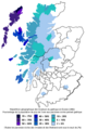 Scottish Gaelic speakers in the 2001 census in Scotland.
 -
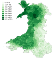 Welsh speakers in the 2011 census in Wales.
 -
 Percentage of Breton speakers in brittany, evaluated in 2004 by the Ofis ar brezhoneg association.


For Cornish and Manx, as they are revived language, it is probably safe to put them as minority languages on the whole of their range.
Globally, the map was a bit optimistic as for the use of Celtic languages, and I revised it in places :
- Brittany was especially a problem, since in that cas the dark green / light green pattern more or less distinguished (somewhat inaccurately) the regions where the language is still spoken from those where it was in the recent centuries. But in a majority / minority pattern, thye whole of Brittany must be in light green since the 2004 survey of the Ofis ar Brezhoneg (a private association at the time) found nowhere a majority of Breton speakers. The extension included the region of Guérande, where Breton was spoken historically but ceased to be during the 19th-20th centuries (cf. fr:Breton de Batz-sur-Mer.
- in Wales, the northernmost Pembrokeshire had to be added as a zone with a Welsh majority, but on the other hand some zones have only a minority according to the 2011 survey : notably the Gower peninsula (which must have been a mistake), a zone around Lampeter, another around Llanwddyn, parts of Snowdonia ; less clearly, Barmouth and Llanbedrog on the Llŷn peninsula.
- in Scotland, Gaelic is a majority language only in the Outer Hebrides and in the north of Skye.