Olst-Wijhe
municipality in the Netherlands
municipality in the Netherlands    .svg)  | |||||
| Upload media | |||||
| Instance of |
| ||||
|---|---|---|---|---|---|
| Location | Overijssel, Netherlands | ||||
| Inception |
| ||||
| Population |
| ||||
| Area |
| ||||
| Elevation above sea level |
| ||||
| Replaces |
| ||||
| official website | |||||
 | |||||
Nederlands: Olst-Wijhe is een gemeente in de provincie Overijssel, Nederland. Het ligt aan de IJssel tussen Deventer en Zwolle.
-
 Locatie
 -
 NH Kerk Olst
 -
 Havezate De Haere, Olst
 -
 RK kerk Wijhe
 -
 Het Baken van Overijssel
 -
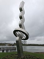
 Sculptuur Neerslager
 -
 Buitenwaarden
 -
 Veerpont Wijhe - Heerde


