Petuelpark
park in Munich, Germany
| Object location | | View all coordinates using: OpenStreetMap |
|---|
park in Munich, Germany  | |||||
| Upload media | |||||
| Instance of | |||||
|---|---|---|---|---|---|
| Location | Munich, Upper Bavaria, Bavaria, Germany | ||||
 | |||||
Panoramics
edit.jpg)
.jpg)
Gallery
edit-
 Near “Platz an der Pfennigparade” view eastwards
 -
 Between „Platz an der Pfennigparade“ and „Platz an der Pfennigparade“ view westwards
 -
 Near “Fontänenplatz” eastwards
.jpg)

.jpg)
Nymphenburg-Biedersteiner channel
editMain category: Nymphenburg-Biedersteiner Kanal
-
 south of the “Platz an der Pfennigparade” (view eastwards)
 -
 south of the “Fontänenplatz” (view westwards)


Surroundings of the park
edit-
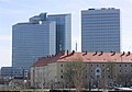 Highlight Towers
