Schiefling am See
municipality in Klagenfurt-Land District, Carinthia, Austria
municipality in Klagenfurt-Land District, Carinthia, Austria   | |||||
| Upload media | |||||
| Instance of |
| ||||
|---|---|---|---|---|---|
| Location | Klagenfurt-Land District, Carinthia, Austria | ||||
| Population |
| ||||
| Area |
| ||||
| Elevation above sea level |
| ||||
| official website | |||||
 | |||||
Aich | Dob edit
...
Albersdorf | Pinja vas edit
-
 English:
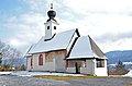
Subsidiary church Saints Ulrich and Martin, north west viewDeutsch:
Filialkirche Heilige Ulrich und Martin, NW-Ansicht -
 English:
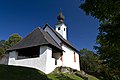
Subsidiary church Saints Ulrich and Martin, south viewDeutsch:
Filialkirche Heilige Ulrich und Martin, Süd-Ansicht -
 English:
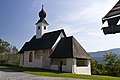
Subsidiary church Saints Ulrich and MartinDeutsch:
Filialkirche Heilige Ulrich und Martin -
 English:
Subsidiary church Saints Ulrich and MartinDeutsch:
Filialkirche Heilige Ulrich und Martin -
 English:
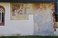
Subsidiary church Saints Ulrich and Martin, frescosDeutsch:
Filialkirche Heilige Ulrich und Martin, Fresken -
 English:
Late Gothic fresco of Saint Christopher on the subsidiary church Saints Ulrich and MartinDeutsch:
Spätgotisches Christophorusfresko an der Filialkirche Heilige Ulrich und Martin -
 English:
Baroque fresco of Martin of Tour on the subsidiary church Saints Ulrich and MartinDeutsch:
Barockes Martinsfresko an der Filialkirche Heilige Ulrich und Martin -
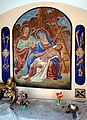
 English:
Baroque altars in the choir of the subsidiary church Saints Ulrich and MartinDeutsch:
Barocke Altäre im Chor der Filialkirche Heilige Ulrich und Martin -
 English:
Baroque high altar in the subsidiary church Saints Ulrich and MartinDeutsch:
Barocker Hochaltar in der Filialkirche Heilige Ulrich und Martin


Auen | Log edit
-
 English:
Apartment buildings, northern viewDeutsch:
Appartement-Häuser, Nord-Ansicht -
 English:
Apartment buildings, northern viewDeutsch:
Appartement-Häuser, Nord-Ansicht -
 English:
Seehotel Vinzenz, northern viewDeutsch:
Seehotel Vinzenz, Nord-Ansicht -
 English:
Northern viewDeutsch:
Nord-Ansicht -
 English:
Northern viewDeutsch:
Nord-Ansicht -
 English:
Northern viewDeutsch:
Nord-Ansicht -
 English:
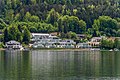
View from TechelsbergDeutsch:
Blick von Techelsberg -
 English:
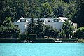
Villa of the Flick family on the Lake WoerthDeutsch:
Villa der Flick-Familie am Wörther See -
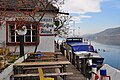
 English:
Restaurant "Weisses Roessl" on Süduferstrasse #111Deutsch:
Restaurant „Weißes Rössl“ an der Süduferstraße 111 -
 English:
Restaurant "Weisses Roessl" on Süduferstrasse #111Deutsch:
Restaurant „Weißes Rössl“ an der Süduferstraße 111 -
 English:
Restaurant "Weisses Roessl" on Süduferstrasse #111Deutsch:
Restaurant „Weißes Rössl“ an der Süduferstraße 111 -
 English:
Shipping pier at the restaurant "Weisses Roessl" on Süduferstrasse #111Deutsch:
Schiffsanlegestelle am Restaurant „Weißes Rössl“ an der Süduferstraße 111 -
 English:
Farmhouse vulgo Krakolnig on QuellenwegDeutsch:
Bauernhof vulgo Krakolnig am Quellenweg


Farrendorf | Paprače edit
...
Goritschach | Goriče edit
-
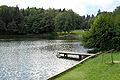 English:
North and west shore of the Trattnig pond with beachDeutsch:
Nord- und Westufer des Trattnigteichs mit Strandbad -
 English:
View from the north to the south of the Trattnig pondDeutsch:
Blick vom Nord- auf das Südufer des Trattnigteichs -
 English:
Restaurant TrattnigDeutsch:
Gasthof Trattnig


Ottosch | Otož edit
...
Penken | Klopce edit
-
 Deutsch:
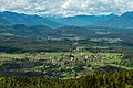
View from the Pyramid BallonEnglish:
Blick vom Pyramidenkogel -
 Deutsch:
View from the Pyramid BallonEnglish:
Blick vom Pyramidenkogel


Raunach | Ravne edit
...
Roach | Rove edit
...
Roda | Roda edit
...
Sankt Kathrein | Podjerberk edit
-
 English:
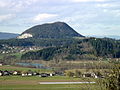
Kathreinkogel (seen from the Pyramid Ballon)Deutsch:
Kathreinkogel (Blick vom Pyramidenkogel) -
 English:
Kathreinkogel (seen from the Pyramid Ballon)Deutsch:
Kathreinkogel (Blick vom Pyramidenkogel) -
 English:
Kathreinkogel (view from Sankt Jakob im Rosental)Deutsch:
Kathreinkogel (Blick von Sankt Jakob im Rosental -
 English:
Church on top of the Kathrein BallonDeutsch:
Kirche auf dem Kathreinkogel -
 English:
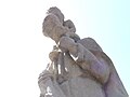
Christopherus-sculpture (assigned to the school of sculptor Switberg Lobisser)Deutsch:
Christopherus-Skulptur (der Schule von Switbert Lobisser zugewiesen) -
 English:
Sculpture of Saint Christopherus (assigned to the sculptor Switbert Lobisser) next to the sanctuary on top of the mountainDeutsch:
Christophorus Skulptur (Switbert Lobisser zugeschrieben) neben dem Gipfelheiligtum


Schiefling | Škofiče edit
Views | Ansichten edit
-
 English:
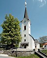
Eastern viewDeutsch:
Ost-Ansicht

Parish church Saint Michael | Pfarrkirche hl. Michael edit
-
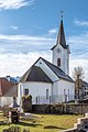
 English:
Northwestern viewDeutsch:
NW-Ansicht -
 English:
Westsouthwestern viewDeutsch:
WSW-Ansicht -
 English:
Eastern viewDeutsch:
Ost-Ansicht -
 English:
Eastnortheastern viewDeutsch:
ONO-Ansicht -
 English:
ApseDeutsch:
Apsis -
 English:
PortalDeutsch:
Portal -
 English:
PortalDeutsch:
Portal -
 English:
Fresco at the southern exterior wallDeutsch:
Fresko an der südlichen Aussenwand -
 English:
Fresco at the southern exterior wallDeutsch:
Fresko an der südlichen Aussenwand -
 English:
Fresco of archangel Michael at the southern wall and sacristyDeutsch:
Fresko des Erzengel Michael an der südlichen Außenwand und Sakristei -
 English:
SacristyDeutsch:
Sakristei -
 English:
InteriorDeutsch:
Innenraum


Rectory | Pfarrhof edit
-
 English:
RectoryDeutsch:
Pfarrhof

Wayside shrine | Bildstock edit
-
 English:
Wayside shrine “Virgin Mother and Child” in the center of SchieflingDeutsch:
“Bildstock Madonna mit Kind” im Ortskern -
 English:
“Virgin Mother and Child” in a wayside shrine in the center of SchieflingDeutsch:
“Madonna mit Kind” in einem Bildstock im Ortskern -
 English:
Wayside shrine “Deposition from the cross” in the center of SchieflingDeutsch:
Bildstock “Kreuzabnahme” im Ortskern -
 English:
“Deposition from the cross” in a wayside shrine in the center of SchieflingDeutsch:
“Kreuzabnahme” in einem Bildstock im Ortskern


Miscellaneous | Diverses edit
-
 English:
War memorial on KirchenstraßeDeutsch:
Kriegerdenkmal an der Kirchenstraße -
 English:
Barn on Kirchenstraße #11Deutsch:
Wirtschaftsgebäude an der Kirchenstraße 11 -
 English:
Municipal hall of SchieflingDeutsch:
Gemeindeamt von Schiefling -
 English:
Bust of the composer Alban Berg in front of the municipal hall of SchieflingDeutsch:
Alban Berg-Büste vor dem Schieflinger Gemeindeamt -
 English:
Bust of the composer Alban Berg in front of the municipal hall of SchieflingDeutsch:
Alban Berg-Büste vor dem Schieflinger Gemeindeamt -
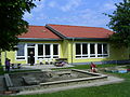 English:
Slovenian / bilingual Kindergarden "Minka" in Schiefling / Škofiče, Carinthia/AustriaDeutsch:
Zweisprachiger Kindergarten Minka


Techelweg | Holbiče edit
-
Deutsch:
View from the Pyramid BallonEnglish:
Blick vom Pyramidenkogel -
Deutsch:
View from the Pyramid BallonEnglish:
Blick vom Pyramidenkogel
Zauchen | Suha edit
...
Insignia and maps edit
-
 Coat of arms
 -
 Location of Schiefling within Carinthia
 -
 Schiefling (17) within the district of Klagenfurt-Land


