-
3D model of cave created according passage walls
-
map in map-editor of XTherion
-
human readable data of scrap (base piece of map)
-
morfing transformation
-
stations are shifted to calculated coordinates, walls and other objects too
-
morfing after loop closure 1 (only survey trip 1) according to calculated coordinates of stations
-
morfing after loop closure 2 (survey trip 1 and 2 without loop closure)
-
morfing after loop closure 3 (survey trip 1 and 2 with loop closure)
-
exported map using symbol set A, source data without any change
-
, source data without any change
-
map with offset
-
map with overlaying passages and one pit (transparent) connected them
-
list of continuations
-
different kinds of survey data typed
-
exported map in Slovak
-
exported map in English
-
map with offset of underlaying part
-
map colored by submaps
-
generated atlas
-
layout - few of parameters you may change the final export
-
import of plt data format
-
example of extreme morfing of sketch before morfing
-
example of extreme morfing of sketch after morfing
-
3D model of cave system with surface elevation model
-
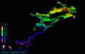
3D model of centerline only
-
representation of objects from which the final map is created - point, line and area in map editor
-
visual representation of objects from which the final map is created - point, line and area - it depends on symbol set
-
export of attributes from therion to GIS
-
Logiciel GHTopo, qui comporte une option d'exportation vers Therion:- par génération d'un fichier .th- par création d'un dossier contenant le fichier thconfig et le fichier thExemple: Grottes du Roy (FR - 65 - Lourdes et Omex)
-
Récupération sous Therion d'un document généré par le logiciel GHTopoExemple: Grottes du Roy (FR - 65 - Lourdes et Omex)
 3D model of cave created according passage walls
 map in map-editor of XTherion
 human readable data of scrap (base piece of map)
 morfing transformation
 stations are shifted to calculated coordinates, walls and other objects too
 morfing after loop closure 1 (only survey trip 1) according to calculated coordinates of stations
 morfing after loop closure 2 (survey trip 1 and 2 without loop closure)
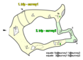 morfing after loop closure 3 (survey trip 1 and 2 with loop closure)
 exported map using symbol set A, source data without any change
 , source data without any change
 map with offset
 map with overlaying passages and one pit (transparent) connected them
 list of continuations
 different kinds of survey data typed
 exported map in Slovak
 exported map in English
 map colored by submaps
 generated atlas
 layout - few of parameters you may change the final export
 import of plt data format
 example of extreme morfing of sketch before morfing
 example of extreme morfing of sketch after morfing
 3D model of cave system with surface elevation model
 3D model of centerline only
 representation of objects from which the final map is created - point, line and area in map editor
 visual representation of objects from which the final map is created - point, line and area - it depends on symbol set
 export of attributes from therion to GIS
 Logiciel GHTopo, qui comporte une option d'exportation vers Therion:- par génération d'un fichier .th- par création d'un dossier contenant le fichier thconfig et le fichier thExemple: Grottes du Roy (FR - 65 - Lourdes et Omex)
 Récupération sous Therion d'un document généré par le logiciel GHTopoExemple: Grottes du Roy (FR - 65 - Lourdes et Omex)


