User:Aristeas/Galleries/Old views and maps
Historical views, maps and other graphics related to towns and places, scanned by me.
Images from Schedel’s Weltchronik (“Nuremberg Chronicle”, 1493)
edit-
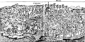
 View of Constantinople
 -
 View of Florence
 -
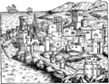
 View of Genova
 -
 View of Rhodes (city)
 -
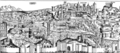 View of Rome
 -

-
 New version, in JPEG format, for better previews
 -
 New high-resolution version
 -
 View of Ulm
.png)


,_compressed.jpg)
.png)
Images from Quadri/Moretti, La Piazza di San Marco in Venice (1831)
edit-
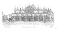
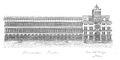
 Quadri/Moretti, plate I
 -
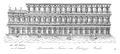
 Quadri/Moretti, plate II
 -
 Quadri/Moretti, plate III
 -
 Quadri/Moretti, plate IV
 -
 Quadri/Moretti, plate V
 -
 Quadri/Moretti, plate VI
 -
 Quadri/Moretti, plate VII
 -
 Quadri/Moretti, plate VIII
 -
 Quadri/Moretti, plate IX
 -
 Quadri/Moretti, plate X
 -
 Quadri/Moretti, plate XI
 -
 Quadri/Moretti, plate XII
 -
 Quadri/Moretti, plate XIII
 -
 Quadri/Moretti, plate XIV
 -
 Quadri/Moretti, plate XV
 -
 Quadri/Moretti, plate XVI
 -
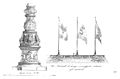
 Quadri/Moretti, frontispiece 1
 -
 Quadri/Moretti, frontispiece 2
 -
 Quadri/Moretti, from title page
,_01.jpg)
,_02.jpg)
,_03.jpg)
,_04.jpg)
,_05.jpg)
,_06.jpg)
,_07.jpg)
,_08.jpg)
,_09.jpg)
,_10.jpg)
,_11.jpg)
,_12.jpg)
,_13.jpg)
,_14.jpg)
,_15.jpg)
,_16.jpg)
,_doge.jpg)
,_horse.jpg)
,_lion.jpg)
Other Images
edit-
 Panoramic view of Assisi (probably 16th century)
 -
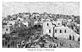
 View of Bethlehem (after a drawing by Karl Oenike, 1894)
 -
 A new scan of the same Bethlehem image
 -
 Map of the castles in Bonfeld, drawn in 1775 by J. C. Waydelin
 -
 Map of Bonfeld about 1830
 -
 Map of Brackenheim in 1835
 -
 Rome, the Villa Medici, by Giovanni Battista Falda, 17th century
 -
 Map of Weimar in 1784
.jpg)

.jpg)


|
Hint: if you need some of the images listed here in higher resolution, special quality etc. for special purposes, just let me know; maybe I can help. Use the E-mail this user feature, or drop me a note on my user talk page. |