Map projections
editThese are the nine map projections by german cartographer Karlheinz Wagner (1906 - 1985). All images are based on the Natural Earth II equirectangular map by Tom Patterson and were created using NASA’s G.Projector software.
I've provided two different sets: The bright colors set is using the original Natural Earth colors, suitable as background for further data visualisation. The dark colors set is suitable for standalone use, i.e. showing the map by itself.
Wagner projections (bright colors)
edit-
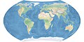
 Wagner I map projection
 -
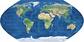
 Wagner II map projection
 -
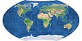
 Wagner III map projection
 -
 Wagner IV map projection
 -
 Wagner V map projection
 -
 Wagner VI map projection
 -
 Wagner VII map projection
 -
 Wagner VIII map projection
 -
 Wagner IX map projection


Wagner projections (dark colors)
edit-
 Wagner I map projection
 -
 Wagner II map projection
 -
 Wagner III map projection
 -
 Wagner IV map projection
 -
 Wagner V map projection
 -
 Wagner VI map projection
 -
 Wagner VII map projection
 -
 Wagner VIII map projection
 -
 Wagner IX map projection


