User:Ebyabe/flrivers
Alapaha River
editnorth of Jennings
edit


Apalachicola River
editnear Fort Gadsden
edit


Amelia River
editFernandina Beach
edit

Aucilla River
editJefferson-Madison County border
edit

Carrabelle River
editCarrabelle
edit
Choctawhatchee River
editBetween Caryville and Westville
edit


Ochlockonee River
editNear Panacea
edit

Near Sopchoppy
edit

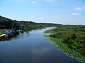
Ocklawaha River
editStarkes Ferry
edit-
 Ocklawaha River: At the Starkes Ferry crossing, looking north.
 -
 Ocklawaha River: Sign on the Starkes Ferry bridge. If you look closely where the concrete part begins on the lower left, though, it says Oklawaha River.
 -
 Ocklawaha River: At the Starkes Ferry crossing, looking south.


Peace River
editArcadia
edit
Near Bowling Green
edit


Zolfo Springs
edit


Santa Fe River
edit


-
 Alachua-Union County border, near Worthington Springs
 -
 Alachua-Union County border, near Worthington Springs
 -
 Alachua-Union County border, near Worthington Springs


Steinhatchee River
edit


St. Johns River
editDeLand
edit
Green Cove Springs
edit
Mayport
edit


Palatka
edit
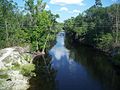
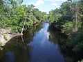
Suwannee River
editBell
edit


Branford
edit-
 Frank R. Norris Bridge, looking west into Lafayette County.
 -
 Frank R. Norris Bridge, looking west into Lafayette County.
 -
 Frank R. Norris Bridge, looking west into Lafayette County.
 -
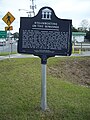 Historical plaque near the Frank R. Norris Bridge.
 -
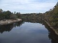 Suwannee River, looking north from the Frank R. Norris Bridge. The river forms the county line here between Suwannee and Lafayette counties.
 -
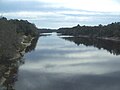 Suwannee River, looking south from the Frank R. Norris Bridge. The river forms the county line here between Suwannee and Lafayette counties.
 -

-

-


Ellaville
edit

Fanning Springs
edit
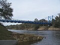
Luraville (Hal W. Adams Bridge)
edit-
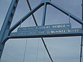 Sign on the bridge
 -
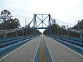
 Carrying SR 51 across the Suwannee River, the border between Suwannee and Lafayette counties. Looking north from the park near the bridge.
 -
 Carrying SR 51 across the Suwannee River, the border between Suwannee and Lafayette counties. Looking north.
 -
 Carrying SR 51 across the Suwannee River, the border between Suwannee and Lafayette counties. Looking north.
 -
 Carrying SR 51 across the Suwannee River, the border between Suwannee and Lafayette counties. Looking north.
 -
 Carrying SR 51 across the Suwannee River, the border between Suwannee and Lafayette counties. Looking north from the center of the bridge.
 -
 Carrying SR 51 across the Suwannee River, the border between Suwannee and Lafayette counties. Looking south from the center of the bridge.
 -
 Carrying SR 51 across the Suwannee River, the border between Suwannee and Lafayette counties. Looking south.
 -
 Carrying SR 51 across the Suwannee River, the border between Suwannee and Lafayette counties. Looking south.
 -
 Carrying SR 51 across the Suwannee River, the border between Suwannee and Lafayette counties. Looking west from the boat ramp in the park near the bridge.
 -
 Carrying SR 51 across the Suwannee River, the border between Suwannee and Lafayette counties. Looking west from the boat ramp in the park near the bridge.
 -
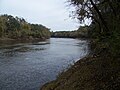 The Suwannee River, looking east from the Hal W. Adams Bridge.
 -
 The Suwannee River, looking east from the Hal W. Adams Bridge.
 -
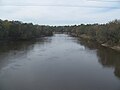 The Suwannee River, looking west from the Hal W. Adams Bridge.


