User:Frettiebot/Galleries/Chmee2/2018/8
Načtené fotografie uživatele Chmee2 za 8/2018
10
edit
11
edit-
![English: Heimey volcanic eruption in 1973 been going through old family albums this photo is after my grandfather Óskar Elías Björnsson On January the 23 of 1973 at around 1 a.m. in the morning, a volcanic eruption of the mountain Eldfell began on Heimaey. The ground on Heimaey started to quake and clefts[clarification needed] began to form. The clefts grew to 1600 meters in length, and soon lava began to erupt. Lava sprayed into the air from fissures in the ground. Volcanic ash was blown out to sea. Later, the situation deteriorated. When the fissures closed, the eruption converted to a concentrated lava flow that headed toward the harbour. The winds changed, and half a million cubic metres of ash were blown on to the town. During the night, the 5000 inhabitants of the island were evacuated, mostly by fishing boats, as almost the entire fishing fleet was in dock.](https://upload.wikimedia.org/wikipedia/commons/thumb/a/ad/Building_fired_by_lava_from_Eldfell_eruption_in_1973.jpg/91px-Building_fired_by_lava_from_Eldfell_eruption_in_1973.jpg) English: Heimey volcanic eruption in 1973 been going through old family albums this photo is after my grandfather Óskar Elías Björnsson On January the 23 of 1973 at around 1 a.m. in the morning, a volcanic eruption of the mountain Eldfell began on Heimaey. The ground on Heimaey started to quake and clefts[clarification needed] began to form. The clefts grew to 1600 meters in length, and soon lava began to erupt. Lava sprayed into the air from fissures in the ground. Volcanic ash was blown out to sea. Later, the situation deteriorated. When the fissures closed, the eruption converted to a concentrated lava flow that headed toward the harbour. The winds changed, and half a million cubic metres of ash were blown on to the town. During the night, the 5000 inhabitants of the island were evacuated, mostly by fishing boats, as almost the entire fishing fleet was in dock.
English: Heimey volcanic eruption in 1973 been going through old family albums this photo is after my grandfather Óskar Elías Björnsson On January the 23 of 1973 at around 1 a.m. in the morning, a volcanic eruption of the mountain Eldfell began on Heimaey. The ground on Heimaey started to quake and clefts[clarification needed] began to form. The clefts grew to 1600 meters in length, and soon lava began to erupt. Lava sprayed into the air from fissures in the ground. Volcanic ash was blown out to sea. Later, the situation deteriorated. When the fissures closed, the eruption converted to a concentrated lava flow that headed toward the harbour. The winds changed, and half a million cubic metres of ash were blown on to the town. During the night, the 5000 inhabitants of the island were evacuated, mostly by fishing boats, as almost the entire fishing fleet was in dock. -
 English: The town of Vestmannaeyjar and the harbor after the eruption. Eldfell and the 1973 lava flows are just beyond the town. Photograph by Robin Holcomb, U.S. Geological Survey.
 -
 English: An ash-laden eruption column rises above a volcanic cone behind the town of Vestmannaeyjar on the island of Heimaey in 1973. The pumping operation in the foreground was designed to cool the front of an advancing lava flow that threatened the town and its harbor. Twenty-two postglacial eruption sites are known in the mostly submarine Vestmannaeyjar volcanic system, which occupies a shallow shelf off the southern coast of Iceland. It contains the renowned island of Surtsey, which grew from the sea floor in an eruption that began in 1963.Photo by Jack Lockwood, 1973 (U.S. Geological Survey).
 -
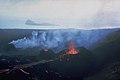 English: Lava flows issue from three small cinder cones on the newly formed island of Surtsey on August 27, 1966. Surtsey began erupting in November 1963 and soon formed a new island. Lava effusion began in April 1964, ensuring that the new island remained permanent. Eruptions at Iceland's newest island continued until 1967. The small island of Jolnir in the background began growing 0.8 km SW of Surtsey at the end of October 1965. It repeatedly was destroyed and grew again above the sea surface before it ceased activity on August 10, 1966.Photo by Richie Williams, 1966 (U.S. Geological Survey).
 -
 English: Two water-filled vents cap Jolnir Island on August 22, 1966, less than two weeks after it ceased erupting. Jolnir was formed during repeated submarine eruptions that began in October 1965 immediately SW of the new island of Surtsey (upper right). Jolnir Island was repeatedly built above sea level and then destroyed by erosion before it ceased activity on August 10. No lava flows were produced at Jolnir, and a month after this photo was taken the loosely consolidated ash deposits disappeared beneath the sea for the final time.
![English: Heimey volcanic eruption in 1973 been going through old family albums this photo is after my grandfather Óskar Elías Björnsson On January the 23 of 1973 at around 1 a.m. in the morning, a volcanic eruption of the mountain Eldfell began on Heimaey. The ground on Heimaey started to quake and clefts[clarification needed] began to form. The clefts grew to 1600 meters in length, and soon lava began to erupt. Lava sprayed into the air from fissures in the ground. Volcanic ash was blown out to sea. Later, the situation deteriorated. When the fissures closed, the eruption converted to a concentrated lava flow that headed toward the harbour. The winds changed, and half a million cubic metres of ash were blown on to the town. During the night, the 5000 inhabitants of the island were evacuated, mostly by fishing boats, as almost the entire fishing fleet was in dock.](/wiki/File:Building_fired_by_lava_from_Eldfell_eruption_in_1973.jpg)


