User:Giftzwerg 88/Fotoprojekt Sulz am Eck
| This is a gallery of files created by Giftzwerg 88. |
Dieses ist die Seite von Fotoprojekt Sulz am Eck, einem Teil von Wildbad. Ziel war die Dokumentation des Orts, ein Großteil, aber nicht alle der älteren Gebäude wurden fotografiert.
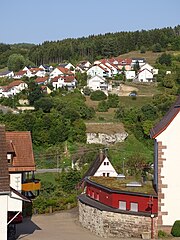
Ortsansicht
edit,_Ortsansicht_01.jpg)
,_Ortsansicht_02.jpg)
,_Ortsansicht_03.jpg)
,_Ortsansicht_04.jpg)
,_Ortsansicht_05.jpg)
,_Ortsansicht_06.jpg)
,_Ortsansicht_07.jpg)
,_Ortsansicht_08.jpg)
,_Ortsansicht_09.jpg)
,_Ortsansicht_10.jpg)
,_Ortsansicht_11.jpg)
,_Ortsansicht_12.jpg)
,_Ortsansicht_13.jpg)
,_Ortsansicht_14.jpg)
,_Ortsansicht_15.jpg)
,_Ortsansicht_16.jpg)
,_Ortsansicht_17.jpg)
,_Ortsansicht_18.jpg)
,_Ortsansicht_19.jpg)
,_Ortsansicht_20.jpg)
,_Ortsansicht_21.jpg)
,_Ortsansicht_22.jpg)
,_Ortsansicht_23.jpg)
,_Ortsansicht_24.jpg)
,_Ortsansicht_25.jpg)
,_Ortsansicht_26.jpg)
,_Ortsansicht_27.jpg)
,_Ortsansicht_28.jpg)
,_Ortsansicht_29.jpg)
,_Ortsansicht_30.jpg)
,_Ortsansicht_31.jpg)
,_Ortsansicht_32.jpg)
,_Ortsansicht_33.jpg)
,_Ortsansicht_34.jpg)
,_Ortsansicht_35.jpg)
,_Ortsansicht_36.jpg)
Gebäude
edit


Gruhe
edit| Object location | | View all coordinates using: OpenStreetMap |
|---|


Friedhof
edit| Object location | | View all coordinates using: OpenStreetMap |
|---|


Evangelisches Gemeindehaus
edit| Object location | | View all coordinates using: OpenStreetMap |
|---|
_01.jpg)
_02.jpg)
_03.jpg)
_04.jpg)
_05.jpg)
_06.jpg)
_07.jpg)
_08.jpg)
_09.jpg)
_10.jpg)
_11.jpg)
_12.jpg)
Kriegsdenkmal
edit| Object location | | View all coordinates using: OpenStreetMap |
|---|
,_Kriegsdenkm%C3%A4ler_01.jpg)
,_Kriegsdenkm%C3%A4ler_02.jpg)
,_Kriegsdenkm%C3%A4ler_03.jpg)
,_Kriegsdenkm%C3%A4ler_04.jpg)
,_Kriegsdenkm%C3%A4ler_05.jpg)
,_Kriegsdenkm%C3%A4ler_06.jpg)
,_Kriegsdenkm%C3%A4ler_07.jpg)
,_Kriegsdenkm%C3%A4ler_08.jpg)
,_Kriegsdenkm%C3%A4ler_09.jpg)
,_Kriegsdenkm%C3%A4ler_10.jpg)
,_Kriegsdenkm%C3%A4ler_11.jpg)
,_Kriegsdenkm%C3%A4ler_12.jpg)
,_Kriegsdenkm%C3%A4ler_13.jpg)
,_Kriegsdenkm%C3%A4ler_14.jpg)
Brunnen
edit


Kirche
edit| Object location | | View all coordinates using: OpenStreetMap |
|---|


Sonstiges in Sulz
edit-

-
 Tierstein
 -
 Tierstein
 -
 Tierstein
 -
 Tierstein
 -

-

-

-

-

-

-

-

-

-

-

-


Schotterwerk
edit| Object location | | View all coordinates using: OpenStreetMap |
|---|


Flugplatz Wächtersberg
edit| Object location | | View all coordinates using: OpenStreetMap |
|---|


Ausblick auf Wildberg vom Wächtersberg
edit| Camera location | | View all coordinates using: OpenStreetMap |
|---|


Ehemaliges Munitionslager
edit| Object location | | View all coordinates using: OpenStreetMap |
|---|


Industriegebiet
edit| Object location | | View all coordinates using: OpenStreetMap |
|---|


