User:National Library of Israel/Maps
John Rapkin Map edit

De Pierre Map edit

Breydenbach Map edit
Nolin Map edit

Vilna Gaon Map edit

Canaan with Bordering Nations edit

Sieber Map edit

Derech Emeth edit


Van De Velde Map edit


Hadera Map edit
-
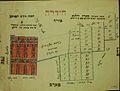 Hadera map sketch

-
 The Madaba Mosaic Map-A mosaic covering part of the floor of a late sixth-century Byzantine Church in Madaba (today in Jordan) representing the Holy Land and the surrounding countries
 -
 The first Palestine map of Ortelius
 -
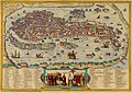 Venice Map from 1572


Acre edit
-
 Civitas Acon sive Ptolomaida-Acre 1500
 -
 Chaifa e S.Gio: Dachiri-Haifa 1770


Bethlehem edit
-
 The way betweene Ierusalem and Bethlem 1621
 -
 Bethlehem Cite de David, et Ville de Judee, ou N. Seigneur prit Naissance 1760


Carmel edit
-
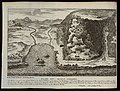
 A Plan of Mount Carmel
 -
 Mount Carmel


Jaffa edit
-
 Old map of Jaffa from 1587
 -
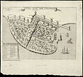
 Old map of Jaffa


Nazareth edit
-
 Old map of Nazareth from 1657
 -
 Old map of Nazareth from 1681


Ramla edit
-
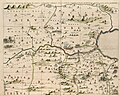
 Old map of Ramla from 1587
 -
 Old map of Ramla from 1657
_1587.jpg)
_1657.jpg)
Rehovot edit
-
 A Plan of Rehovot 1897

Mount Tabor edit
-
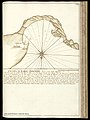
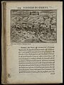
 A map of Mount Tabor from 1714
 -
 A map of Mount Tabor from 1677


Terre sainte edit
-
 A map of the Land of Israel from 1729
 -
 A map of the Land of Israel from 1729
 -
 A map of Israel from 1637
 -
 A map of Israel from 1639


Tribes of Israel edit
-
 A map of the land of the tribe of Asher, One of the twelve Israel tribes
 -
 A map describing Tribes of Israel from 1658
 -
 A map of a Tribe of Simeon. One of the twelve tribes of Israel from 1658
 -
 A map of the Tribes of Benjamin and Ephraim from 1658


