User:Pere prlpz/gallery/25
Arxiu anterior: User:Pere prlpz/gallery/24
2013-09-06 20:36:12 edit
-
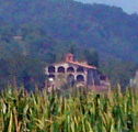
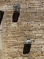
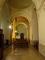
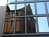 Català: Convent de Pompeia reflectit a la façana del Deutsche Bank. Av. Diagonal, 450 - c/ Riera de Sant Miquel, 1 (Barcelona).
This is a photo of a building indexed in the Catalan heritage register as Bé Cultural d'Interès Local (BCIL) under the reference 08019/2548.
Object location 
View all coordinates using: OpenStreetMap 
-
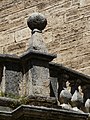
 Català: Edifici Mariano Pidelaserra. C/ Balmes, 178-180 - c/ Comte de Salvatierra, 1-3 (Barcelona).
This is a photo of a building indexed in the Catalan heritage register as Bé Cultural d'Interès Local (BCIL) under the reference 08019/2199.
Object location View all coordinates using: OpenStreetMap -
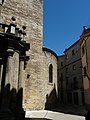
 Català: Edifici Roca Barallat. Via Augusta, 12 - pl. Narcís Oller, 10 (Barcelona).
This is a photo of a building indexed in the Catalan heritage register as Bé Cultural d'Interès Local (BCIL) under the reference 08019/2529.
Object location View all coordinates using: OpenStreetMap


2013-09-06 20:39:01 edit
-
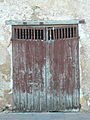
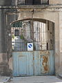
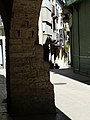
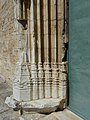
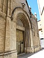
 Català: Farmàcia Sanromà. c/ de la Unió, 17 (Tarragona).
This is a photo of a building indexed in the Catalan heritage register as Bé Cultural d'Interès Local (BCIL) under the reference IPA-12546.
Object location View all coordinates using: OpenStreetMap -
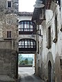
 Català: Farmàcia Sanromà. c/ de la Unió, 17 (Tarragona).
This is a photo of a building indexed in the Catalan heritage register as Bé Cultural d'Interès Local (BCIL) under the reference IPA-12546.
Object location View all coordinates using: OpenStreetMap -
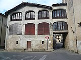
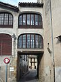
 Català: Farmàcia Sanromà. c/ de la Unió, 17 (Tarragona).
This is a photo of a building indexed in the Catalan heritage register as Bé Cultural d'Interès Local (BCIL) under the reference IPA-12546.
Object location View all coordinates using: OpenStreetMap


2013-09-06 20:38:45 edit
-
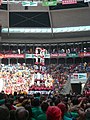
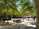
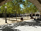
 Català: Concurs de Castells de Tarragona 2012, a la Plaça de Toros, o Plaça de Braus. c/ Eivissa - c/ Jaume I - c/ Mallorca (Tarragona).
This is a photo of a building indexed in the Catalan heritage register as Bé Cultural d'Interès Local (BCIL) under the reference IPA-12477.
Object location View all coordinates using: OpenStreetMap -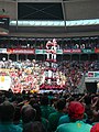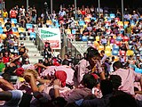
 Català: Concurs de Castells de Tarragona 2012, a la Plaça de Toros, o Plaça de Braus. c/ Eivissa - c/ Jaume I - c/ Mallorca (Tarragona).
This is a photo of a building indexed in the Catalan heritage register as Bé Cultural d'Interès Local (BCIL) under the reference IPA-12477.
Object location View all coordinates using: OpenStreetMap


2013-09-06 21:44:41 edit
-
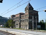
 Català: Estació vella de Ripoll. C. Progrés (Ripoll).
This is a photo of a building indexed in the Catalan heritage register as Bé Cultural d'Interès Local (BCIL) under the reference IPA-4163.
Object location View all coordinates using: OpenStreetMap -
 Català: Estació vella de Ripoll. C. Progrés (Ripoll).
This is a photo of a building indexed in the Catalan heritage register as Bé Cultural d'Interès Local (BCIL) under the reference IPA-4163.
Object location View all coordinates using: OpenStreetMap -
 Català: Estació vella de Ripoll. C. Progrés (Ripoll).
This is a photo of a building indexed in the Catalan heritage register as Bé Cultural d'Interès Local (BCIL) under the reference IPA-4163.
Object location View all coordinates using: OpenStreetMap -
 Català: Estació vella de Ripoll. C. Progrés (Ripoll).
This is a photo of a building indexed in the Catalan heritage register as Bé Cultural d'Interès Local (BCIL) under the reference IPA-4163.
Object location View all coordinates using: OpenStreetMap -
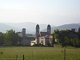
 Català: Masia el Vilar. Solell Avall, ctra. 151, km 7 (Sant Joan de les Abadesses).
This is a photo of a building indexed in the Catalan heritage register as Bé Cultural d'Interès Local (BCIL) under the reference IPA-6752.
Object location View all coordinates using: OpenStreetMap -
![]]. Pl. de l'Abat Oliba (Sant Joan de les Abadesses). This is a photo of a monument indexed in the Spanish heritage register of Bienes de Interés Cultural under the reference RI-51-0000565. Object location 42° 13′ 57.54″ N, 2° 17′ 10.81″ E View all coordinates using: OpenStreetMap](https://upload.wikimedia.org/wikipedia/commons/thumb/2/24/Monestir_de_Sant_Joan_de_les_Abadesses_P1460368.jpg/160px-Monestir_de_Sant_Joan_de_les_Abadesses_P1460368.jpg) ]]. Pl. de l'Abat Oliba (Sant Joan de les Abadesses).
]]. Pl. de l'Abat Oliba (Sant Joan de les Abadesses).
This is a photo of a monument indexed in the Spanish heritage register of Bienes de Interés Cultural under the reference RI-51-0000565.
Object location View all coordinates using: OpenStreetMap -
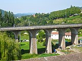
 Català: Pont Vell de Sant Joan de les Abadesses. (Sant Joan de les Abadesses).
This is a photo of a building indexed in the Catalan heritage register as Bé Cultural d'Interès Local (BCIL) under the reference IPA-4316.
Object location View all coordinates using: OpenStreetMap -
 Català: Escola Mestre Andreu, o Escoles Nacionals. C. Mestre Andreu (Sant Joan de les Abadesses).
This is a photo of a building indexed in the Catalan heritage register as Bé Cultural d'Interès Local (BCIL) under the reference IPA-4279.
Object location View all coordinates using: OpenStreetMap -
 Català: Pont Nou de Sant Joan de les Abadesses. (Sant Joan de les Abadesses).
This is a photo of a building indexed in the Catalan heritage register as Bé Cultural d'Interès Local (BCIL) under the reference IPA-4317.
Object location View all coordinates using: OpenStreetMap -
 Català: Pont Vell de Sant Joan de les Abadesses. (Sant Joan de les Abadesses).
This is a photo of a building indexed in the Catalan heritage register as Bé Cultural d'Interès Local (BCIL) under the reference IPA-4316.
Object location View all coordinates using: OpenStreetMap -
 Català: Església de Sant Pol, o Església de Sant Joanipol. Pl. Clavé (Sant Joan de les Abadesses).
This is a photo of a monument indexed in the Spanish heritage register of Bienes de Interés Cultural under the reference RI-51-0001659.
Object location View all coordinates using: OpenStreetMap


![]]. Pl. de l'Abat Oliba (Sant Joan de les Abadesses). This is a photo of a monument indexed in the Spanish heritage register of Bienes de Interés Cultural under the reference RI-51-0000565. Object location 42° 13′ 57.54″ N, 2° 17′ 10.81″ E View all coordinates using: OpenStreetMap](/wiki/File:Monestir_de_Sant_Joan_de_les_Abadesses_P1460368.jpg)


2013-09-06 22:03:21 edit
-
![]]. Pl. Rector Ferrer (Olot). This is a photo of a monument indexed in the Spanish heritage register of Bienes de Interés Cultural under the reference RI-51-0007065. Object location 42° 10′ 56″ N, 2° 29′ 18″ E View all coordinates using: OpenStreetMap](https://upload.wikimedia.org/wikipedia/commons/thumb/8/8e/Sant_Esteve_d%27Olot_P1460394.jpg/160px-Sant_Esteve_d%27Olot_P1460394.jpg) ]]. Pl. Rector Ferrer (Olot).
]]. Pl. Rector Ferrer (Olot).
This is a photo of a monument indexed in the Spanish heritage register of Bienes de Interés Cultural under the reference RI-51-0007065.
Object location View all coordinates using: OpenStreetMap -
![]]. Pl. Rector Ferrer (Olot). This is a photo of a monument indexed in the Spanish heritage register of Bienes de Interés Cultural under the reference RI-51-0007065. Object location 42° 10′ 56″ N, 2° 29′ 18″ E View all coordinates using: OpenStreetMap](https://upload.wikimedia.org/wikipedia/commons/thumb/0/05/Sant_Esteve_d%27Olot_P1460395.jpg/90px-Sant_Esteve_d%27Olot_P1460395.jpg) ]]. Pl. Rector Ferrer (Olot).
]]. Pl. Rector Ferrer (Olot).
This is a photo of a monument indexed in the Spanish heritage register of Bienes de Interés Cultural under the reference RI-51-0007065.
Object location View all coordinates using: OpenStreetMap -
 Català: Església de Sant Francesc. Camí al Montsacopa (Olot).
This is a photo of a building indexed in the Catalan heritage register as Bé Cultural d'Interès Local (BCIL) under the reference IPA-10351.
Object location View all coordinates using: OpenStreetMap -
 Català: Pont de Sant Roc. Barri de Sant Roc (Olot).
This is a photo of a building indexed in the Catalan heritage register as Bé Cultural d'Interès Local (BCIL) under the reference IPA-10273.
Object location View all coordinates using: OpenStreetMap -
 Català: Pont de Sant Roc. Barri de Sant Roc (Olot).
This is a photo of a building indexed in the Catalan heritage register as Bé Cultural d'Interès Local (BCIL) under the reference IPA-10273.
Object location View all coordinates using: OpenStreetMap -
 Català: Pont de Sant Roc. Barri de Sant Roc (Olot).
This is a photo of a building indexed in the Catalan heritage register as Bé Cultural d'Interès Local (BCIL) under the reference IPA-10273.
Object location View all coordinates using: OpenStreetMap -
 Català: Ponts i túnels de l'antic Carrilet. Traçat de Sant Roc al Mas Tussols (Olot).
This is a photo of a building indexed in the Catalan heritage register as Bé Cultural d'Interès Local (BCIL) under the reference IPA-41026.
![]]. Pl. Rector Ferrer (Olot). This is a photo of a monument indexed in the Spanish heritage register of Bienes de Interés Cultural under the reference RI-51-0007065. Object location 42° 10′ 56″ N, 2° 29′ 18″ E View all coordinates using: OpenStreetMap](/wiki/File:Sant_Esteve_d%27Olot_P1460394.jpg)
![]]. Pl. Rector Ferrer (Olot). This is a photo of a monument indexed in the Spanish heritage register of Bienes de Interés Cultural under the reference RI-51-0007065. Object location 42° 10′ 56″ N, 2° 29′ 18″ E View all coordinates using: OpenStreetMap](/wiki/File:Sant_Esteve_d%27Olot_P1460395.jpg)


2013-09-06 22:34:13 edit
-
 Català: Benefici de Sant Segimon. C. Sant Pere, 1 (Les Preses).
This is a photo of a building indexed in the Catalan heritage register as Bé Cultural d'Interès Local (BCIL) under the reference IPA-10107.
Object location View all coordinates using: OpenStreetMap -
 Català: Benefici de Sant Segimon. C. Sant Pere, 1 (Les Preses).
This is a photo of a building indexed in the Catalan heritage register as Bé Cultural d'Interès Local (BCIL) under the reference IPA-10107.
Object location View all coordinates using: OpenStreetMap -
 Català: La Bertrana. C. Major (Les Preses).
This is a photo of a building indexed in the Catalan heritage register as Bé Cultural d'Interès Local (BCIL) under the reference IPA-10111.
Object location View all coordinates using: OpenStreetMap -
 Català: La Bertrana. C. Major (Les Preses).
This is a photo of a building indexed in the Catalan heritage register as Bé Cultural d'Interès Local (BCIL) under the reference IPA-10111.
Object location View all coordinates using: OpenStreetMap -
 Català: La Bertrana. C. Major (Les Preses).
This is a photo of a building indexed in the Catalan heritage register as Bé Cultural d'Interès Local (BCIL) under the reference IPA-10111.
Object location View all coordinates using: OpenStreetMap -
 Català: La Bertrana. C. Major (Les Preses).
This is a photo of a building indexed in the Catalan heritage register as Bé Cultural d'Interès Local (BCIL) under the reference IPA-10111.
Object location View all coordinates using: OpenStreetMap -
 Català: La Bertrana. C. Major (Les Preses).
This is a photo of a building indexed in the Catalan heritage register as Bé Cultural d'Interès Local (BCIL) under the reference IPA-10111.
Object location View all coordinates using: OpenStreetMap -
 Català: La Bertrana. C. Major (Les Preses).
This is a photo of a building indexed in the Catalan heritage register as Bé Cultural d'Interès Local (BCIL) under the reference IPA-10111.
Object location View all coordinates using: OpenStreetMap -
 Català: La Mata. C. Sant Pere, 2 (Les Preses).
This is a photo of a building indexed in the Catalan heritage register as Bé Cultural d'Interès Local (BCIL) under the reference IPA-10105.
Object location View all coordinates using: OpenStreetMap -
 Català: La Mata. C. Sant Pere, 2 (Les Preses).
This is a photo of a building indexed in the Catalan heritage register as Bé Cultural d'Interès Local (BCIL) under the reference IPA-10105.
Object location View all coordinates using: OpenStreetMap -
 Català: La Mata. C. Sant Pere, 2 (Les Preses).
This is a photo of a building indexed in the Catalan heritage register as Bé Cultural d'Interès Local (BCIL) under the reference IPA-10105.
Object location View all coordinates using: OpenStreetMap -
 Català: La Mata. C. Sant Pere, 2 (Les Preses).
This is a photo of a building indexed in the Catalan heritage register as Bé Cultural d'Interès Local (BCIL) under the reference IPA-10105.
Object location View all coordinates using: OpenStreetMap -
 Català: La Mata. C. Sant Pere, 2 (Les Preses).
This is a photo of a building indexed in the Catalan heritage register as Bé Cultural d'Interès Local (BCIL) under the reference IPA-10105.
Object location View all coordinates using: OpenStreetMap -
 Català: La Mata. C. Sant Pere, 2 (Les Preses).
This is a photo of a building indexed in the Catalan heritage register as Bé Cultural d'Interès Local (BCIL) under the reference IPA-10105.
Object location View all coordinates using: OpenStreetMap -
 Català: La Mata. C. Sant Pere, 2 (Les Preses).
This is a photo of a building indexed in the Catalan heritage register as Bé Cultural d'Interès Local (BCIL) under the reference IPA-10105.
Object location View all coordinates using: OpenStreetMap -
 Català: La Mata. C. Sant Pere, 2 (Les Preses).
This is a photo of a building indexed in the Catalan heritage register as Bé Cultural d'Interès Local (BCIL) under the reference IPA-10105.
Object location View all coordinates using: OpenStreetMap -
 Català: Masia Codella. (Les Preses).
This is a photo of a building indexed in the Catalan heritage register as Bé Cultural d'Interès Local (BCIL) under the reference IPA-10101.
Object location View all coordinates using: OpenStreetMap -
 Català: Masia Codella. (Les Preses).
This is a photo of a building indexed in the Catalan heritage register as Bé Cultural d'Interès Local (BCIL) under the reference IPA-10101.
Object location View all coordinates using: OpenStreetMap


2013-09-06 23:29:52 edit
-
 Català: Estació del Carrilet. C. de la Fàbrica (Anglès).
This is a photo of a building indexed in the Catalan heritage register as Bé Cultural d'Interès Local (BCIL) under the reference IPA-26633.
Object location View all coordinates using: OpenStreetMap -
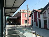
 Català: Fàbrica Burés, o Indústries Burés. C. de la Fàbrica (Anglès).
This is a photo of a building indexed in the Catalan heritage register as Bé Cultural d'Interès Local (BCIL) under the reference IPA-26632.
Object location View all coordinates using: OpenStreetMap -
 Català: Fàbrica Burés, o Indústries Burés. C. de la Fàbrica (Anglès).
This is a photo of a building indexed in the Catalan heritage register as Bé Cultural d'Interès Local (BCIL) under the reference IPA-26632.
Object location View all coordinates using: OpenStreetMap -
![]]. C. Sta. Eugènia, 42 (Girona). This is a photo of a building indexed in the Catalan heritage register as Bé Cultural d'Interès Local (BCIL) under the reference IPA-21251. Object location 41° 58′ 54″ N, 2° 48′ 58″ E View all coordinates using: OpenStreetMap](https://upload.wikimedia.org/wikipedia/commons/thumb/5/50/Farinera_Teixidor_des_de_l%27estaci%C3%B3_del_tren_P1460536.jpg/160px-Farinera_Teixidor_des_de_l%27estaci%C3%B3_del_tren_P1460536.jpg) ]]. C. Sta. Eugènia, 42 (Girona).
]]. C. Sta. Eugènia, 42 (Girona).
This is a photo of a building indexed in the Catalan heritage register as Bé Cultural d'Interès Local (BCIL) under the reference IPA-21251.
Object location View all coordinates using: OpenStreetMap -
 Català: Antiga estació del tren d'Olot. C. Santa Eugènia (Girona).
This is a photo of a building indexed in the Catalan heritage register as Bé Cultural d'Interès Local (BCIL) under the reference IPA-21278.
Object location View all coordinates using: OpenStreetMap


![]]. C. Sta. Eugènia, 42 (Girona). This is a photo of a building indexed in the Catalan heritage register as Bé Cultural d'Interès Local (BCIL) under the reference IPA-21251. Object location 41° 58′ 54″ N, 2° 48′ 58″ E View all coordinates using: OpenStreetMap](/wiki/File:Farinera_Teixidor_des_de_l%27estaci%C3%B3_del_tren_P1460536.jpg)

2013-09-07 00:18:44 edit
-
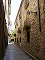 Català: Cases del carrer de la Paraireria. C. Paraireria (Banyoles).
This is a photo of a building indexed in the Catalan heritage register as Bé Cultural d'Interès Local (BCIL) under the reference IPA-14983.
Object location View all coordinates using: OpenStreetMap -
 Català: Carrer Nou. C. Nou (Banyoles).
This is a photo of a building indexed in the Catalan heritage register as Bé Cultural d'Interès Local (BCIL) under the reference IPA-14982.
Object location View all coordinates using: OpenStreetMap -
 Català: Carrer Nou. C. Nou (Banyoles).
This is a photo of a building indexed in the Catalan heritage register as Bé Cultural d'Interès Local (BCIL) under the reference IPA-14982.
Object location View all coordinates using: OpenStreetMap -
 Català: Carrer Nou. C. Nou (Banyoles).
This is a photo of a building indexed in the Catalan heritage register as Bé Cultural d'Interès Local (BCIL) under the reference IPA-14982.
Object location View all coordinates using: OpenStreetMap -
 Català: Carrer Nou. C. Nou (Banyoles).
This is a photo of a building indexed in the Catalan heritage register as Bé Cultural d'Interès Local (BCIL) under the reference IPA-14982.
Object location View all coordinates using: OpenStreetMap -
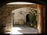
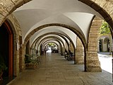
 Català: Llotja del Tint. C. de Sant Pere (Banyoles).
This is a photo of a building indexed in the Catalan heritage register as Bé Cultural d'Interès Local (BCIL) under the reference IPA-14988.
Object location View all coordinates using: OpenStreetMap -
 Català: Llotja del Tint. C. de Sant Pere (Banyoles).
This is a photo of a building indexed in the Catalan heritage register as Bé Cultural d'Interès Local (BCIL) under the reference IPA-14988.
Object location View all coordinates using: OpenStreetMap -
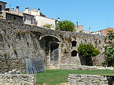
 Català: Muralla de Banyoles. C. Pia Almoina (Banyoles).
This is a photo of a building indexed in the Catalan heritage register as Bé Cultural d'Interès Local (BCIL) under the reference IPA-14981.
Object location View all coordinates using: OpenStreetMap -
 Català: Muralla de Banyoles. C. Pia Almoina (Banyoles).
This is a photo of a building indexed in the Catalan heritage register as Bé Cultural d'Interès Local (BCIL) under the reference IPA-14981.
Object location View all coordinates using: OpenStreetMap -
 Català: Muralla de Banyoles. C. Pia Almoina (Banyoles).
This is a photo of a building indexed in the Catalan heritage register as Bé Cultural d'Interès Local (BCIL) under the reference IPA-14981.
Object location View all coordinates using: OpenStreetMap -
 Català: Muralla de Banyoles. C. Pia Almoina (Banyoles).
This is a photo of a building indexed in the Catalan heritage register as Bé Cultural d'Interès Local (BCIL) under the reference IPA-14981.
Object location View all coordinates using: OpenStreetMap -
 Català: Muralla de Banyoles. C. Pia Almoina (Banyoles).
This is a photo of a building indexed in the Catalan heritage register as Bé Cultural d'Interès Local (BCIL) under the reference IPA-14981.
Object location View all coordinates using: OpenStreetMap -
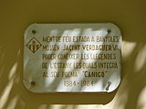
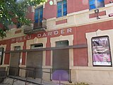 Català: Museu Darder. Pl. dels Estudis, 2 (Banyoles).
This is a photo of a building indexed in the Catalan heritage register as Bé Cultural d'Interès Local (BCIL) under the reference IPA-37599.
Object location View all coordinates using: OpenStreetMap -
 Català: Museu Darder. Pl. dels Estudis, 2 (Banyoles).
This is a photo of a building indexed in the Catalan heritage register as Bé Cultural d'Interès Local (BCIL) under the reference IPA-37599.
Object location View all coordinates using: OpenStreetMap -
 Català: Pia Almoina. Pl. de la Font (Banyoles).
This is a photo of a monument indexed in the Spanish heritage register of Bienes de Interés Cultural under the reference RI-51-0001352.
Object location View all coordinates using: OpenStreetMap -
 Català: Pia Almoina. Pl. de la Font (Banyoles).
This is a photo of a monument indexed in the Spanish heritage register of Bienes de Interés Cultural under the reference RI-51-0001352.
Object location View all coordinates using: OpenStreetMap -
 Català: Pia Almoina. Pl. de la Font (Banyoles).
This is a photo of a monument indexed in the Spanish heritage register of Bienes de Interés Cultural under the reference RI-51-0001352.
Object location View all coordinates using: OpenStreetMap -
 Català: Pia Almoina. Pl. de la Font (Banyoles).
This is a photo of a monument indexed in the Spanish heritage register of Bienes de Interés Cultural under the reference RI-51-0001352.
Object location View all coordinates using: OpenStreetMap -
 Català: Pia Almoina. Pl. de la Font (Banyoles).
This is a photo of a monument indexed in the Spanish heritage register of Bienes de Interés Cultural under the reference RI-51-0001352.
Object location View all coordinates using: OpenStreetMap -
 Català: Pia Almoina. Pl. de la Font (Banyoles).
This is a photo of a monument indexed in the Spanish heritage register of Bienes de Interés Cultural under the reference RI-51-0001352.
Object location View all coordinates using: OpenStreetMap -
 Català: Placeta de la Font. (Banyoles).
This is a photo of a building indexed in the Catalan heritage register as Bé Cultural d'Interès Local (BCIL) under the reference IPA-14936.
Object location View all coordinates using: OpenStreetMap -
 Català: Placeta de la Font. (Banyoles).
This is a photo of a building indexed in the Catalan heritage register as Bé Cultural d'Interès Local (BCIL) under the reference IPA-14936.
Object location View all coordinates using: OpenStreetMap -
 Català: Plaça Major, o la Plaça. Pl. Major (Banyoles).
This is a photo of a historical area indexed in the Spanish heritage register of Bienes de Interés Cultural under the reference RI-53-0000511.
Object location View all coordinates using: OpenStreetMap -
 Català: Plaça Major, o la Plaça. Pl. Major (Banyoles).
This is a photo of a historical area indexed in the Spanish heritage register of Bienes de Interés Cultural under the reference RI-53-0000511.
Object location View all coordinates using: OpenStreetMap -
 Català: Plaça Major, o la Plaça. Pl. Major (Banyoles).
This is a photo of a historical area indexed in the Spanish heritage register of Bienes de Interés Cultural under the reference RI-53-0000511.
Object location View all coordinates using: OpenStreetMap -
 Català: Plaça Major, o la Plaça. Pl. Major (Banyoles).
This is a photo of a historical area indexed in the Spanish heritage register of Bienes de Interés Cultural under the reference RI-53-0000511.
Object location View all coordinates using: OpenStreetMap -
 Català: Plaça Major, o la Plaça. Pl. Major (Banyoles).
This is a photo of a historical area indexed in the Spanish heritage register of Bienes de Interés Cultural under the reference RI-53-0000511.
Object location View all coordinates using: OpenStreetMap -
 Català: Plaça Major, o la Plaça. Pl. Major (Banyoles).
This is a photo of a historical area indexed in the Spanish heritage register of Bienes de Interés Cultural under the reference RI-53-0000511.
Object location View all coordinates using: OpenStreetMap -
 Català: Plaça Major, o la Plaça. Pl. Major (Banyoles).
This is a photo of a historical area indexed in the Spanish heritage register of Bienes de Interés Cultural under the reference RI-53-0000511.
Object location View all coordinates using: OpenStreetMap -
 Català: Plaça Major, o la Plaça. Pl. Major (Banyoles).
This is a photo of a historical area indexed in the Spanish heritage register of Bienes de Interés Cultural under the reference RI-53-0000511.
Object location View all coordinates using: OpenStreetMap -
 Català: Plaça Major, o la Plaça. Pl. Major (Banyoles).
This is a photo of a historical area indexed in the Spanish heritage register of Bienes de Interés Cultural under the reference RI-53-0000511.
Object location View all coordinates using: OpenStreetMap -
 Català: Plaça Major, o la Plaça. Pl. Major (Banyoles).
This is a photo of a historical area indexed in the Spanish heritage register of Bienes de Interés Cultural under the reference RI-53-0000511.
Object location View all coordinates using: OpenStreetMap -
 Català: Plaça Major, o la Plaça. Pl. Major (Banyoles).
This is a photo of a historical area indexed in the Spanish heritage register of Bienes de Interés Cultural under the reference RI-53-0000511.
Object location View all coordinates using: OpenStreetMap -
 Català: Plaça Major, o la Plaça. Pl. Major (Banyoles).
This is a photo of a historical area indexed in the Spanish heritage register of Bienes de Interés Cultural under the reference RI-53-0000511.
Object location View all coordinates using: OpenStreetMap -
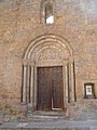
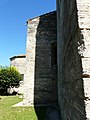
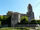
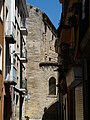
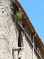
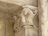
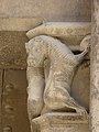
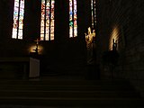
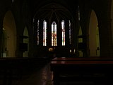
 Català: Monestir de Sant Esteve. Pl. del Monestir (Banyoles).
This is a photo of a monument indexed in the Spanish heritage register of Bienes de Interés Cultural under the reference RI-51-0003922.
Object location View all coordinates using: OpenStreetMap -
 Català: Monestir de Sant Esteve. Pl. del Monestir (Banyoles).
This is a photo of a monument indexed in the Spanish heritage register of Bienes de Interés Cultural under the reference RI-51-0003922.
Object location View all coordinates using: OpenStreetMap -
 Català: Monestir de Sant Esteve. Pl. del Monestir (Banyoles).
This is a photo of a monument indexed in the Spanish heritage register of Bienes de Interés Cultural under the reference RI-51-0003922.
Object location View all coordinates using: OpenStreetMap -
 Català: Monestir de Sant Esteve. Pl. del Monestir (Banyoles).
This is a photo of a monument indexed in the Spanish heritage register of Bienes de Interés Cultural under the reference RI-51-0003922.
Object location View all coordinates using: OpenStreetMap -
 Català: Monestir de Sant Esteve. Pl. del Monestir (Banyoles).
This is a photo of a monument indexed in the Spanish heritage register of Bienes de Interés Cultural under the reference RI-51-0003922.
Object location View all coordinates using: OpenStreetMap -
 Català: Monestir de Sant Esteve. Pl. del Monestir (Banyoles).
This is a photo of a monument indexed in the Spanish heritage register of Bienes de Interés Cultural under the reference RI-51-0003922.
Object location View all coordinates using: OpenStreetMap -
 Català: Monestir de Sant Esteve. Pl. del Monestir (Banyoles).
This is a photo of a monument indexed in the Spanish heritage register of Bienes de Interés Cultural under the reference RI-51-0003922.
Object location View all coordinates using: OpenStreetMap -
 Català: Monestir de Sant Esteve. Pl. del Monestir (Banyoles).
This is a photo of a monument indexed in the Spanish heritage register of Bienes de Interés Cultural under the reference RI-51-0003922.
Object location View all coordinates using: OpenStreetMap -
 Català: Monestir de Sant Esteve. Pl. del Monestir (Banyoles).
This is a photo of a monument indexed in the Spanish heritage register of Bienes de Interés Cultural under the reference RI-51-0003922.
Object location View all coordinates using: OpenStreetMap -
 Català: Monestir de Sant Esteve. Pl. del Monestir (Banyoles).
This is a photo of a monument indexed in the Spanish heritage register of Bienes de Interés Cultural under the reference RI-51-0003922.
Object location View all coordinates using: OpenStreetMap -
 Català: Monestir de Sant Esteve. Pl. del Monestir (Banyoles).
This is a photo of a monument indexed in the Spanish heritage register of Bienes de Interés Cultural under the reference RI-51-0003922.
Object location View all coordinates using: OpenStreetMap -
 Català: Monestir de Sant Esteve. Pl. del Monestir (Banyoles).
This is a photo of a monument indexed in the Spanish heritage register of Bienes de Interés Cultural under the reference RI-51-0003922.
Object location View all coordinates using: OpenStreetMap -
 Català: Monestir de Sant Esteve. Pl. del Monestir (Banyoles).
This is a photo of a monument indexed in the Spanish heritage register of Bienes de Interés Cultural under the reference RI-51-0003922.
Object location View all coordinates using: OpenStreetMap -
 Català: Monestir de Sant Esteve. Pl. del Monestir (Banyoles).
This is a photo of a monument indexed in the Spanish heritage register of Bienes de Interés Cultural under the reference RI-51-0003922.
Object location View all coordinates using: OpenStreetMap -
 Català: Església parroquial de Santa Maria dels Turers, o Santa Maria del Turario. Pl. de Santa Maria (Banyoles).
This is a photo of a building indexed in the Catalan heritage register as Bé Cultural d'Interès Local (BCIL) under the reference IPA-14989.
Object location View all coordinates using: OpenStreetMap


2013-09-07 00:18:44 edit
-
Català: Cases del carrer de la Paraireria. C. Paraireria (Banyoles).
This is a photo of a building indexed in the Catalan heritage register as Bé Cultural d'Interès Local (BCIL) under the reference IPA-14983.
Object location View all coordinates using: OpenStreetMap -
Català: Carrer Nou. C. Nou (Banyoles).
This is a photo of a building indexed in the Catalan heritage register as Bé Cultural d'Interès Local (BCIL) under the reference IPA-14982.
Object location View all coordinates using: OpenStreetMap -
Català: Carrer Nou. C. Nou (Banyoles).
This is a photo of a building indexed in the Catalan heritage register as Bé Cultural d'Interès Local (BCIL) under the reference IPA-14982.
Object location View all coordinates using: OpenStreetMap -
Català: Carrer Nou. C. Nou (Banyoles).
This is a photo of a building indexed in the Catalan heritage register as Bé Cultural d'Interès Local (BCIL) under the reference IPA-14982.
Object location View all coordinates using: OpenStreetMap -
Català: Carrer Nou. C. Nou (Banyoles).
This is a photo of a building indexed in the Catalan heritage register as Bé Cultural d'Interès Local (BCIL) under the reference IPA-14982.
Object location View all coordinates using: OpenStreetMap -
Català: Llotja del Tint. C. de Sant Pere (Banyoles).
This is a photo of a building indexed in the Catalan heritage register as Bé Cultural d'Interès Local (BCIL) under the reference IPA-14988.
Object location View all coordinates using: OpenStreetMap -
Català: Llotja del Tint. C. de Sant Pere (Banyoles).
This is a photo of a building indexed in the Catalan heritage register as Bé Cultural d'Interès Local (BCIL) under the reference IPA-14988.
Object location View all coordinates using: OpenStreetMap -
Català: Muralla de Banyoles. C. Pia Almoina (Banyoles).
This is a photo of a building indexed in the Catalan heritage register as Bé Cultural d'Interès Local (BCIL) under the reference IPA-14981.
Object location View all coordinates using: OpenStreetMap -
Català: Muralla de Banyoles. C. Pia Almoina (Banyoles).
This is a photo of a building indexed in the Catalan heritage register as Bé Cultural d'Interès Local (BCIL) under the reference IPA-14981.
Object location View all coordinates using: OpenStreetMap -
Català: Muralla de Banyoles. C. Pia Almoina (Banyoles).
This is a photo of a building indexed in the Catalan heritage register as Bé Cultural d'Interès Local (BCIL) under the reference IPA-14981.
Object location View all coordinates using: OpenStreetMap -
Català: Muralla de Banyoles. C. Pia Almoina (Banyoles).
This is a photo of a building indexed in the Catalan heritage register as Bé Cultural d'Interès Local (BCIL) under the reference IPA-14981.
Object location View all coordinates using: OpenStreetMap -
Català: Muralla de Banyoles. C. Pia Almoina (Banyoles).
This is a photo of a building indexed in the Catalan heritage register as Bé Cultural d'Interès Local (BCIL) under the reference IPA-14981.
Object location View all coordinates using: OpenStreetMap -
Català: Museu Darder. Pl. dels Estudis, 2 (Banyoles).
This is a photo of a building indexed in the Catalan heritage register as Bé Cultural d'Interès Local (BCIL) under the reference IPA-37599.
Object location View all coordinates using: OpenStreetMap -
Català: Museu Darder. Pl. dels Estudis, 2 (Banyoles).
This is a photo of a building indexed in the Catalan heritage register as Bé Cultural d'Interès Local (BCIL) under the reference IPA-37599.
Object location View all coordinates using: OpenStreetMap -
Català: Pia Almoina. Pl. de la Font (Banyoles).
This is a photo of a monument indexed in the Spanish heritage register of Bienes de Interés Cultural under the reference RI-51-0001352.
Object location View all coordinates using: OpenStreetMap -
Català: Pia Almoina. Pl. de la Font (Banyoles).
This is a photo of a monument indexed in the Spanish heritage register of Bienes de Interés Cultural under the reference RI-51-0001352.
Object location View all coordinates using: OpenStreetMap -
Català: Pia Almoina. Pl. de la Font (Banyoles).
This is a photo of a monument indexed in the Spanish heritage register of Bienes de Interés Cultural under the reference RI-51-0001352.
Object location View all coordinates using: OpenStreetMap -
Català: Pia Almoina. Pl. de la Font (Banyoles).
This is a photo of a monument indexed in the Spanish heritage register of Bienes de Interés Cultural under the reference RI-51-0001352.
Object location View all coordinates using: OpenStreetMap -
Català: Pia Almoina. Pl. de la Font (Banyoles).
This is a photo of a monument indexed in the Spanish heritage register of Bienes de Interés Cultural under the reference RI-51-0001352.
Object location View all coordinates using: OpenStreetMap -
Català: Pia Almoina. Pl. de la Font (Banyoles).
This is a photo of a monument indexed in the Spanish heritage register of Bienes de Interés Cultural under the reference RI-51-0001352.
Object location View all coordinates using: OpenStreetMap -
Català: Placeta de la Font. (Banyoles).
This is a photo of a building indexed in the Catalan heritage register as Bé Cultural d'Interès Local (BCIL) under the reference IPA-14936.
Object location View all coordinates using: OpenStreetMap -
Català: Placeta de la Font. (Banyoles).
This is a photo of a building indexed in the Catalan heritage register as Bé Cultural d'Interès Local (BCIL) under the reference IPA-14936.
Object location View all coordinates using: OpenStreetMap -
Català: Plaça Major, o la Plaça. Pl. Major (Banyoles).
This is a photo of a historical area indexed in the Spanish heritage register of Bienes de Interés Cultural under the reference RI-53-0000511.
Object location View all coordinates using: OpenStreetMap -
Català: Plaça Major, o la Plaça. Pl. Major (Banyoles).
This is a photo of a historical area indexed in the Spanish heritage register of Bienes de Interés Cultural under the reference RI-53-0000511.
Object location View all coordinates using: OpenStreetMap -
Català: Plaça Major, o la Plaça. Pl. Major (Banyoles).
This is a photo of a historical area indexed in the Spanish heritage register of Bienes de Interés Cultural under the reference RI-53-0000511.
Object location View all coordinates using: OpenStreetMap -
Català: Plaça Major, o la Plaça. Pl. Major (Banyoles).
This is a photo of a historical area indexed in the Spanish heritage register of Bienes de Interés Cultural under the reference RI-53-0000511.
Object location View all coordinates using: OpenStreetMap -
Català: Plaça Major, o la Plaça. Pl. Major (Banyoles).
This is a photo of a historical area indexed in the Spanish heritage register of Bienes de Interés Cultural under the reference RI-53-0000511.
Object location View all coordinates using: OpenStreetMap -
Català: Plaça Major, o la Plaça. Pl. Major (Banyoles).
This is a photo of a historical area indexed in the Spanish heritage register of Bienes de Interés Cultural under the reference RI-53-0000511.
Object location View all coordinates using: OpenStreetMap -
Català: Plaça Major, o la Plaça. Pl. Major (Banyoles).
This is a photo of a historical area indexed in the Spanish heritage register of Bienes de Interés Cultural under the reference RI-53-0000511.
Object location View all coordinates using: OpenStreetMap -
Català: Plaça Major, o la Plaça. Pl. Major (Banyoles).
This is a photo of a historical area indexed in the Spanish heritage register of Bienes de Interés Cultural under the reference RI-53-0000511.
Object location View all coordinates using: OpenStreetMap -
Català: Plaça Major, o la Plaça. Pl. Major (Banyoles).
This is a photo of a historical area indexed in the Spanish heritage register of Bienes de Interés Cultural under the reference RI-53-0000511.
Object location View all coordinates using: OpenStreetMap -
Català: Plaça Major, o la Plaça. Pl. Major (Banyoles).
This is a photo of a historical area indexed in the Spanish heritage register of Bienes de Interés Cultural under the reference RI-53-0000511.
Object location View all coordinates using: OpenStreetMap -
Català: Plaça Major, o la Plaça. Pl. Major (Banyoles).
This is a photo of a historical area indexed in the Spanish heritage register of Bienes de Interés Cultural under the reference RI-53-0000511.
Object location View all coordinates using: OpenStreetMap -
Català: Plaça Major, o la Plaça. Pl. Major (Banyoles).
This is a photo of a historical area indexed in the Spanish heritage register of Bienes de Interés Cultural under the reference RI-53-0000511.
Object location View all coordinates using: OpenStreetMap -
Català: Monestir de Sant Esteve. Pl. del Monestir (Banyoles).
This is a photo of a monument indexed in the Spanish heritage register of Bienes de Interés Cultural under the reference RI-51-0003922.
Object location View all coordinates using: OpenStreetMap -
Català: Monestir de Sant Esteve. Pl. del Monestir (Banyoles).
This is a photo of a monument indexed in the Spanish heritage register of Bienes de Interés Cultural under the reference RI-51-0003922.
Object location View all coordinates using: OpenStreetMap -
Català: Monestir de Sant Esteve. Pl. del Monestir (Banyoles).
This is a photo of a monument indexed in the Spanish heritage register of Bienes de Interés Cultural under the reference RI-51-0003922.
Object location View all coordinates using: OpenStreetMap -
Català: Monestir de Sant Esteve. Pl. del Monestir (Banyoles).
This is a photo of a monument indexed in the Spanish heritage register of Bienes de Interés Cultural under the reference RI-51-0003922.
Object location View all coordinates using: OpenStreetMap -
Català: Monestir de Sant Esteve. Pl. del Monestir (Banyoles).
This is a photo of a monument indexed in the Spanish heritage register of Bienes de Interés Cultural under the reference RI-51-0003922.
Object location View all coordinates using: OpenStreetMap -
Català: Monestir de Sant Esteve. Pl. del Monestir (Banyoles).
This is a photo of a monument indexed in the Spanish heritage register of Bienes de Interés Cultural under the reference RI-51-0003922.
Object location View all coordinates using: OpenStreetMap -
Català: Monestir de Sant Esteve. Pl. del Monestir (Banyoles).
This is a photo of a monument indexed in the Spanish heritage register of Bienes de Interés Cultural under the reference RI-51-0003922.
Object location View all coordinates using: OpenStreetMap -
Català: Monestir de Sant Esteve. Pl. del Monestir (Banyoles).
This is a photo of a monument indexed in the Spanish heritage register of Bienes de Interés Cultural under the reference RI-51-0003922.
Object location View all coordinates using: OpenStreetMap -
Català: Monestir de Sant Esteve. Pl. del Monestir (Banyoles).
This is a photo of a monument indexed in the Spanish heritage register of Bienes de Interés Cultural under the reference RI-51-0003922.
Object location View all coordinates using: OpenStreetMap -
Català: Monestir de Sant Esteve. Pl. del Monestir (Banyoles).
This is a photo of a monument indexed in the Spanish heritage register of Bienes de Interés Cultural under the reference RI-51-0003922.
Object location View all coordinates using: OpenStreetMap -
Català: Monestir de Sant Esteve. Pl. del Monestir (Banyoles).
This is a photo of a monument indexed in the Spanish heritage register of Bienes de Interés Cultural under the reference RI-51-0003922.
Object location View all coordinates using: OpenStreetMap -
Català: Monestir de Sant Esteve. Pl. del Monestir (Banyoles).
This is a photo of a monument indexed in the Spanish heritage register of Bienes de Interés Cultural under the reference RI-51-0003922.
Object location View all coordinates using: OpenStreetMap -
Català: Monestir de Sant Esteve. Pl. del Monestir (Banyoles).
This is a photo of a monument indexed in the Spanish heritage register of Bienes de Interés Cultural under the reference RI-51-0003922.
Object location View all coordinates using: OpenStreetMap -
Català: Monestir de Sant Esteve. Pl. del Monestir (Banyoles).
This is a photo of a monument indexed in the Spanish heritage register of Bienes de Interés Cultural under the reference RI-51-0003922.
Object location View all coordinates using: OpenStreetMap -
Català: Església parroquial de Santa Maria dels Turers, o Santa Maria del Turario. Pl. de Santa Maria (Banyoles).
This is a photo of a building indexed in the Catalan heritage register as Bé Cultural d'Interès Local (BCIL) under the reference IPA-14989.
Object location View all coordinates using: OpenStreetMap
2013-09-07 19:51:16 edit
-
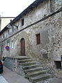
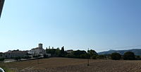
 Català: Ca l'Alegret. Veïnat de l'Ortigós (La Bisbal del Penedès).
This is a photo of a building indexed in the Catalan heritage register as Bé Cultural d'Interès Local (BCIL) under the reference IPA-5314.
Object location View all coordinates using: OpenStreetMap -
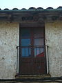
 Català: Església de Nostra Senyora dels Àngels del Papiolet. C. de Torregrassa, el Papiolet (Sant Jaume dels Domenys).
This is a photo of a building indexed in the Catalan heritage register as Bé Cultural d'Interès Local (BCIL) under the reference IPA-5424.
Object location View all coordinates using: OpenStreetMap -
 Català: Ca l'Alegret. Veïnat de l'Ortigós (La Bisbal del Penedès).
This is a photo of a building indexed in the Catalan heritage register as Bé Cultural d'Interès Local (BCIL) under the reference IPA-5314.
Object location View all coordinates using: OpenStreetMap -
 Català: Ca l'Alegret. Veïnat de l'Ortigós (La Bisbal del Penedès).
This is a photo of a building indexed in the Catalan heritage register as Bé Cultural d'Interès Local (BCIL) under the reference IPA-5314.
Object location View all coordinates using: OpenStreetMap -
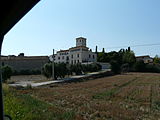 Català: Ca l'Alegret. Veïnat de l'Ortigós (La Bisbal del Penedès).
This is a photo of a building indexed in the Catalan heritage register as Bé Cultural d'Interès Local (BCIL) under the reference IPA-5314.
Object location View all coordinates using: OpenStreetMap -
 Català: Ca l'Alegret. Veïnat de l'Ortigós (La Bisbal del Penedès).
This is a photo of a building indexed in the Catalan heritage register as Bé Cultural d'Interès Local (BCIL) under the reference IPA-5314.
Object location View all coordinates using: OpenStreetMap -
 Català: Ca l'Alegret. Veïnat de l'Ortigós (La Bisbal del Penedès).
This is a photo of a building indexed in the Catalan heritage register as Bé Cultural d'Interès Local (BCIL) under the reference IPA-5314.
Object location View all coordinates using: OpenStreetMap -
 Català: Església parroquial de Santa Maria. C. Major (La Bisbal del Penedès).
This is a photo of a building indexed in the Catalan heritage register as Bé Cultural d'Interès Local (BCIL) under the reference IPA-5312.
Object location View all coordinates using: OpenStreetMap -
 Català: Església parroquial de Santa Maria. C. Major (La Bisbal del Penedès).
This is a photo of a building indexed in the Catalan heritage register as Bé Cultural d'Interès Local (BCIL) under the reference IPA-5312.
Object location View all coordinates using: OpenStreetMap -
 Català: Església parroquial de Santa Maria. C. Major (La Bisbal del Penedès).
This is a photo of a building indexed in the Catalan heritage register as Bé Cultural d'Interès Local (BCIL) under the reference IPA-5312.
Object location View all coordinates using: OpenStreetMap -
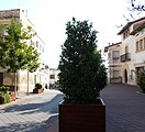 Català: Església parroquial de Santa Maria. C. Major (La Bisbal del Penedès). Nota: la identificació es basa en l'altra foto del castell que hi ha a Commons, però no coincideix exactament amb les coordenades ni amb la descripció de PatMapa.
This is a photo of a building indexed in the Catalan heritage register as Bé Cultural d'Interès Local (BCIL) under the reference IPA-5312.
Object location View all coordinates using: OpenStreetMap -
 Català: Església parroquial de Santa Maria. C. Major (La Bisbal del Penedès).
This is a photo of a building indexed in the Catalan heritage register as Bé Cultural d'Interès Local (BCIL) under the reference IPA-5312.
Object location View all coordinates using: OpenStreetMap -
 Català: Església parroquial de Santa Maria. C. Major (La Bisbal del Penedès).
This is a photo of a building indexed in the Catalan heritage register as Bé Cultural d'Interès Local (BCIL) under the reference IPA-5312.
Object location View all coordinates using: OpenStreetMap -
 Català: Església parroquial de Santa Maria. C. Major (La Bisbal del Penedès).
This is a photo of a building indexed in the Catalan heritage register as Bé Cultural d'Interès Local (BCIL) under the reference IPA-5312.
Object location View all coordinates using: OpenStreetMap


2013-09-07 22:02:57 edit
-
![]], Torre de Dalt). Camí de Santa Margarida de Valldonzella (Barcelona). This is a photo of a building indexed in the Catalan heritage register as Bé Cultural d'Interès Local (BCIL) under the reference 08019/2520. Object location 41° 24′ 23.95″ N, 2° 04′ 16.56″ E View all coordinates using: OpenStreetMap](https://upload.wikimedia.org/wikipedia/commons/thumb/1/1e/Torre_de_Santa_Margarida_P1080453.jpg/160px-Torre_de_Santa_Margarida_P1080453.jpg) ]], Torre de Dalt). Camí de Santa Margarida de Valldonzella (Barcelona).
]], Torre de Dalt). Camí de Santa Margarida de Valldonzella (Barcelona).
This is a photo of a building indexed in the Catalan heritage register as Bé Cultural d'Interès Local (BCIL) under the reference 08019/2520.
Object location View all coordinates using: OpenStreetMap -
![]], Torre de Dalt). Camí de Santa Margarida de Valldonzella (Barcelona). This is a photo of a building indexed in the Catalan heritage register as Bé Cultural d'Interès Local (BCIL) under the reference 08019/2520. Object location 41° 24′ 23.95″ N, 2° 04′ 16.56″ E View all coordinates using: OpenStreetMap](https://upload.wikimedia.org/wikipedia/commons/thumb/6/6a/Torre_de_Santa_Margarida_P1080452.jpg/160px-Torre_de_Santa_Margarida_P1080452.jpg) ]], Torre de Dalt). Camí de Santa Margarida de Valldonzella (Barcelona).
]], Torre de Dalt). Camí de Santa Margarida de Valldonzella (Barcelona).
This is a photo of a building indexed in the Catalan heritage register as Bé Cultural d'Interès Local (BCIL) under the reference 08019/2520.
Object location View all coordinates using: OpenStreetMap -
![]], Torre de Dalt). Camí de Santa Margarida de Valldonzella (Barcelona). This is a photo of a building indexed in the Catalan heritage register as Bé Cultural d'Interès Local (BCIL) under the reference 08019/2520. Object location 41° 24′ 23.95″ N, 2° 04′ 16.56″ E View all coordinates using: OpenStreetMap](https://upload.wikimedia.org/wikipedia/commons/thumb/3/3a/Torre_de_Santa_Margarida_P1080445.jpg/160px-Torre_de_Santa_Margarida_P1080445.jpg) ]], Torre de Dalt). Camí de Santa Margarida de Valldonzella (Barcelona).
]], Torre de Dalt). Camí de Santa Margarida de Valldonzella (Barcelona).
This is a photo of a building indexed in the Catalan heritage register as Bé Cultural d'Interès Local (BCIL) under the reference 08019/2520.
Object location View all coordinates using: OpenStreetMap -
![]], Torre de Dalt). Camí de Santa Margarida de Valldonzella (Barcelona). This is a photo of a building indexed in the Catalan heritage register as Bé Cultural d'Interès Local (BCIL) under the reference 08019/2520. Object location 41° 24′ 23.95″ N, 2° 04′ 16.56″ E View all coordinates using: OpenStreetMap](https://upload.wikimedia.org/wikipedia/commons/thumb/2/2f/Torre_de_Santa_Margarida_P1080510.jpg/160px-Torre_de_Santa_Margarida_P1080510.jpg) ]], Torre de Dalt). Camí de Santa Margarida de Valldonzella (Barcelona).
]], Torre de Dalt). Camí de Santa Margarida de Valldonzella (Barcelona).
This is a photo of a building indexed in the Catalan heritage register as Bé Cultural d'Interès Local (BCIL) under the reference 08019/2520.
Object location View all coordinates using: OpenStreetMap -
![]], Torre de Dalt). Camí de Santa Margarida de Valldonzella (Barcelona). This is a photo of a building indexed in the Catalan heritage register as Bé Cultural d'Interès Local (BCIL) under the reference 08019/2520. Object location 41° 24′ 23.95″ N, 2° 04′ 16.56″ E View all coordinates using: OpenStreetMap](https://upload.wikimedia.org/wikipedia/commons/thumb/a/a1/Torre_de_Santa_Margarida_P1080509.jpg/160px-Torre_de_Santa_Margarida_P1080509.jpg) ]], Torre de Dalt). Camí de Santa Margarida de Valldonzella (Barcelona).
]], Torre de Dalt). Camí de Santa Margarida de Valldonzella (Barcelona).
This is a photo of a building indexed in the Catalan heritage register as Bé Cultural d'Interès Local (BCIL) under the reference 08019/2520.
Object location View all coordinates using: OpenStreetMap -
![]], Torre de Dalt). Camí de Santa Margarida de Valldonzella (Barcelona). This is a photo of a building indexed in the Catalan heritage register as Bé Cultural d'Interès Local (BCIL) under the reference 08019/2520. Object location 41° 24′ 23.95″ N, 2° 04′ 16.56″ E View all coordinates using: OpenStreetMap](https://upload.wikimedia.org/wikipedia/commons/thumb/7/73/Torre_de_Santa_Margarida_P1080508.jpg/160px-Torre_de_Santa_Margarida_P1080508.jpg) ]], Torre de Dalt). Camí de Santa Margarida de Valldonzella (Barcelona).
]], Torre de Dalt). Camí de Santa Margarida de Valldonzella (Barcelona).
This is a photo of a building indexed in the Catalan heritage register as Bé Cultural d'Interès Local (BCIL) under the reference 08019/2520.
Object location View all coordinates using: OpenStreetMap -
![]], Torre de Dalt). Camí de Santa Margarida de Valldonzella (Barcelona). This is a photo of a building indexed in the Catalan heritage register as Bé Cultural d'Interès Local (BCIL) under the reference 08019/2520. Object location 41° 24′ 23.95″ N, 2° 04′ 16.56″ E View all coordinates using: OpenStreetMap](https://upload.wikimedia.org/wikipedia/commons/thumb/9/90/Torre_de_Santa_Margarida_P1080507.jpg/160px-Torre_de_Santa_Margarida_P1080507.jpg) ]], Torre de Dalt). Camí de Santa Margarida de Valldonzella (Barcelona).
]], Torre de Dalt). Camí de Santa Margarida de Valldonzella (Barcelona).
This is a photo of a building indexed in the Catalan heritage register as Bé Cultural d'Interès Local (BCIL) under the reference 08019/2520.
Object location View all coordinates using: OpenStreetMap -
![]], Torre de Dalt). Camí de Santa Margarida de Valldonzella (Barcelona). This is a photo of a building indexed in the Catalan heritage register as Bé Cultural d'Interès Local (BCIL) under the reference 08019/2520. Object location 41° 24′ 23.95″ N, 2° 04′ 16.56″ E View all coordinates using: OpenStreetMap](https://upload.wikimedia.org/wikipedia/commons/thumb/9/9f/Torre_de_Santa_Margarida_P1080500.jpg/90px-Torre_de_Santa_Margarida_P1080500.jpg) ]], Torre de Dalt). Camí de Santa Margarida de Valldonzella (Barcelona).
]], Torre de Dalt). Camí de Santa Margarida de Valldonzella (Barcelona).
This is a photo of a building indexed in the Catalan heritage register as Bé Cultural d'Interès Local (BCIL) under the reference 08019/2520.
Object location View all coordinates using: OpenStreetMap -
![]], Torre de Dalt). Camí de Santa Margarida de Valldonzella (Barcelona). This is a photo of a building indexed in the Catalan heritage register as Bé Cultural d'Interès Local (BCIL) under the reference 08019/2520. Object location 41° 24′ 23.95″ N, 2° 04′ 16.56″ E View all coordinates using: OpenStreetMap](https://upload.wikimedia.org/wikipedia/commons/thumb/7/7c/Torre_de_Santa_Margarida_P1080499.jpg/90px-Torre_de_Santa_Margarida_P1080499.jpg) ]], Torre de Dalt). Camí de Santa Margarida de Valldonzella (Barcelona).
]], Torre de Dalt). Camí de Santa Margarida de Valldonzella (Barcelona).
This is a photo of a building indexed in the Catalan heritage register as Bé Cultural d'Interès Local (BCIL) under the reference 08019/2520.
Object location View all coordinates using: OpenStreetMap -
![]], Torre de Dalt). Camí de Santa Margarida de Valldonzella (Barcelona). This is a photo of a building indexed in the Catalan heritage register as Bé Cultural d'Interès Local (BCIL) under the reference 08019/2520. Object location 41° 24′ 23.95″ N, 2° 04′ 16.56″ E View all coordinates using: OpenStreetMap](https://upload.wikimedia.org/wikipedia/commons/thumb/a/a7/Torre_de_Santa_Margarida_P1080498.jpg/160px-Torre_de_Santa_Margarida_P1080498.jpg) ]], Torre de Dalt). Camí de Santa Margarida de Valldonzella (Barcelona).
]], Torre de Dalt). Camí de Santa Margarida de Valldonzella (Barcelona).
This is a photo of a building indexed in the Catalan heritage register as Bé Cultural d'Interès Local (BCIL) under the reference 08019/2520.
Object location View all coordinates using: OpenStreetMap -
![]], Torre de Dalt). Camí de Santa Margarida de Valldonzella (Barcelona). This is a photo of a building indexed in the Catalan heritage register as Bé Cultural d'Interès Local (BCIL) under the reference 08019/2520. Object location 41° 24′ 23.95″ N, 2° 04′ 16.56″ E View all coordinates using: OpenStreetMap](https://upload.wikimedia.org/wikipedia/commons/thumb/c/c7/Torre_de_Santa_Margarida_P1080497.jpg/160px-Torre_de_Santa_Margarida_P1080497.jpg) ]], Torre de Dalt). Camí de Santa Margarida de Valldonzella (Barcelona).
]], Torre de Dalt). Camí de Santa Margarida de Valldonzella (Barcelona).
This is a photo of a building indexed in the Catalan heritage register as Bé Cultural d'Interès Local (BCIL) under the reference 08019/2520.
Object location View all coordinates using: OpenStreetMap -
![]], Torre de Dalt). Camí de Santa Margarida de Valldonzella (Barcelona). This is a photo of a building indexed in the Catalan heritage register as Bé Cultural d'Interès Local (BCIL) under the reference 08019/2520. Object location 41° 24′ 23.95″ N, 2° 04′ 16.56″ E View all coordinates using: OpenStreetMap](https://upload.wikimedia.org/wikipedia/commons/thumb/9/9b/Torre_de_Santa_Margarida_P1080496.jpg/90px-Torre_de_Santa_Margarida_P1080496.jpg) ]], Torre de Dalt). Camí de Santa Margarida de Valldonzella (Barcelona).
]], Torre de Dalt). Camí de Santa Margarida de Valldonzella (Barcelona).
This is a photo of a building indexed in the Catalan heritage register as Bé Cultural d'Interès Local (BCIL) under the reference 08019/2520.
Object location View all coordinates using: OpenStreetMap -
![]], Torre de Dalt). Camí de Santa Margarida de Valldonzella (Barcelona). This is a photo of a building indexed in the Catalan heritage register as Bé Cultural d'Interès Local (BCIL) under the reference 08019/2520. Object location 41° 24′ 23.95″ N, 2° 04′ 16.56″ E View all coordinates using: OpenStreetMap](https://upload.wikimedia.org/wikipedia/commons/thumb/9/97/Torre_de_Santa_Margarida_P1080495.jpg/160px-Torre_de_Santa_Margarida_P1080495.jpg) ]], Torre de Dalt). Camí de Santa Margarida de Valldonzella (Barcelona).
]], Torre de Dalt). Camí de Santa Margarida de Valldonzella (Barcelona).
This is a photo of a building indexed in the Catalan heritage register as Bé Cultural d'Interès Local (BCIL) under the reference 08019/2520.
Object location View all coordinates using: OpenStreetMap -
![]], Torre de Dalt). Camí de Santa Margarida de Valldonzella (Barcelona). This is a photo of a building indexed in the Catalan heritage register as Bé Cultural d'Interès Local (BCIL) under the reference 08019/2520. Object location 41° 24′ 23.95″ N, 2° 04′ 16.56″ E View all coordinates using: OpenStreetMap](https://upload.wikimedia.org/wikipedia/commons/thumb/7/76/Torre_de_Santa_Margarida_P1080494.jpg/160px-Torre_de_Santa_Margarida_P1080494.jpg) ]], Torre de Dalt). Camí de Santa Margarida de Valldonzella (Barcelona).
]], Torre de Dalt). Camí de Santa Margarida de Valldonzella (Barcelona).
This is a photo of a building indexed in the Catalan heritage register as Bé Cultural d'Interès Local (BCIL) under the reference 08019/2520.
Object location View all coordinates using: OpenStreetMap -
![]], Torre de Dalt). Camí de Santa Margarida de Valldonzella (Barcelona). This is a photo of a building indexed in the Catalan heritage register as Bé Cultural d'Interès Local (BCIL) under the reference 08019/2520. Object location 41° 24′ 23.95″ N, 2° 04′ 16.56″ E View all coordinates using: OpenStreetMap](https://upload.wikimedia.org/wikipedia/commons/thumb/0/02/Torre_de_Santa_Margarida_P1080492.jpg/90px-Torre_de_Santa_Margarida_P1080492.jpg) ]], Torre de Dalt). Camí de Santa Margarida de Valldonzella (Barcelona).
]], Torre de Dalt). Camí de Santa Margarida de Valldonzella (Barcelona).
This is a photo of a building indexed in the Catalan heritage register as Bé Cultural d'Interès Local (BCIL) under the reference 08019/2520.
Object location View all coordinates using: OpenStreetMap -
![]], Torre de Dalt). Camí de Santa Margarida de Valldonzella (Barcelona). This is a photo of a building indexed in the Catalan heritage register as Bé Cultural d'Interès Local (BCIL) under the reference 08019/2520. Object location 41° 24′ 23.95″ N, 2° 04′ 16.56″ E View all coordinates using: OpenStreetMap](https://upload.wikimedia.org/wikipedia/commons/thumb/a/a8/Torre_de_Santa_Margarida_P1080491.jpg/90px-Torre_de_Santa_Margarida_P1080491.jpg) ]], Torre de Dalt). Camí de Santa Margarida de Valldonzella (Barcelona).
]], Torre de Dalt). Camí de Santa Margarida de Valldonzella (Barcelona).
This is a photo of a building indexed in the Catalan heritage register as Bé Cultural d'Interès Local (BCIL) under the reference 08019/2520.
Object location View all coordinates using: OpenStreetMap -
![]], Torre de Dalt). Camí de Santa Margarida de Valldonzella (Barcelona). This is a photo of a building indexed in the Catalan heritage register as Bé Cultural d'Interès Local (BCIL) under the reference 08019/2520. Object location 41° 24′ 23.95″ N, 2° 04′ 16.56″ E View all coordinates using: OpenStreetMap](https://upload.wikimedia.org/wikipedia/commons/thumb/2/23/Torre_de_Santa_Margarida_P1080490.jpg/160px-Torre_de_Santa_Margarida_P1080490.jpg) ]], Torre de Dalt). Camí de Santa Margarida de Valldonzella (Barcelona).
]], Torre de Dalt). Camí de Santa Margarida de Valldonzella (Barcelona).
This is a photo of a building indexed in the Catalan heritage register as Bé Cultural d'Interès Local (BCIL) under the reference 08019/2520.
Object location View all coordinates using: OpenStreetMap -
![]], Torre de Dalt). Camí de Santa Margarida de Valldonzella (Barcelona). This is a photo of a building indexed in the Catalan heritage register as Bé Cultural d'Interès Local (BCIL) under the reference 08019/2520. Object location 41° 24′ 23.95″ N, 2° 04′ 16.56″ E View all coordinates using: OpenStreetMap](https://upload.wikimedia.org/wikipedia/commons/thumb/7/78/Torre_de_Santa_Margarida_P1080489.jpg/160px-Torre_de_Santa_Margarida_P1080489.jpg) ]], Torre de Dalt). Camí de Santa Margarida de Valldonzella (Barcelona).
]], Torre de Dalt). Camí de Santa Margarida de Valldonzella (Barcelona).
This is a photo of a building indexed in the Catalan heritage register as Bé Cultural d'Interès Local (BCIL) under the reference 08019/2520.
Object location View all coordinates using: OpenStreetMap -
![]], Torre de Dalt). Camí de Santa Margarida de Valldonzella (Barcelona). This is a photo of a building indexed in the Catalan heritage register as Bé Cultural d'Interès Local (BCIL) under the reference 08019/2520. Object location 41° 24′ 23.95″ N, 2° 04′ 16.56″ E View all coordinates using: OpenStreetMap](https://upload.wikimedia.org/wikipedia/commons/thumb/f/f8/Torre_de_Santa_Margarida_P1080483.jpg/160px-Torre_de_Santa_Margarida_P1080483.jpg) ]], Torre de Dalt). Camí de Santa Margarida de Valldonzella (Barcelona).
]], Torre de Dalt). Camí de Santa Margarida de Valldonzella (Barcelona).
This is a photo of a building indexed in the Catalan heritage register as Bé Cultural d'Interès Local (BCIL) under the reference 08019/2520.
Object location View all coordinates using: OpenStreetMap -
![]], Torre de Dalt). Camí de Santa Margarida de Valldonzella (Barcelona). This is a photo of a building indexed in the Catalan heritage register as Bé Cultural d'Interès Local (BCIL) under the reference 08019/2520. Object location 41° 24′ 23.95″ N, 2° 04′ 16.56″ E View all coordinates using: OpenStreetMap](https://upload.wikimedia.org/wikipedia/commons/thumb/6/61/Torre_de_Santa_Margarida_P1080482.jpg/90px-Torre_de_Santa_Margarida_P1080482.jpg) ]], Torre de Dalt). Camí de Santa Margarida de Valldonzella (Barcelona).
]], Torre de Dalt). Camí de Santa Margarida de Valldonzella (Barcelona).
This is a photo of a building indexed in the Catalan heritage register as Bé Cultural d'Interès Local (BCIL) under the reference 08019/2520.
Object location View all coordinates using: OpenStreetMap -
![]], Torre de Dalt). Camí de Santa Margarida de Valldonzella (Barcelona). This is a photo of a building indexed in the Catalan heritage register as Bé Cultural d'Interès Local (BCIL) under the reference 08019/2520. Object location 41° 24′ 23.95″ N, 2° 04′ 16.56″ E View all coordinates using: OpenStreetMap](https://upload.wikimedia.org/wikipedia/commons/thumb/7/74/Torre_de_Santa_Margarida_P1080481.jpg/90px-Torre_de_Santa_Margarida_P1080481.jpg) ]], Torre de Dalt). Camí de Santa Margarida de Valldonzella (Barcelona).
]], Torre de Dalt). Camí de Santa Margarida de Valldonzella (Barcelona).
This is a photo of a building indexed in the Catalan heritage register as Bé Cultural d'Interès Local (BCIL) under the reference 08019/2520.
Object location View all coordinates using: OpenStreetMap -
![]], Torre de Dalt). Camí de Santa Margarida de Valldonzella (Barcelona). This is a photo of a building indexed in the Catalan heritage register as Bé Cultural d'Interès Local (BCIL) under the reference 08019/2520. Object location 41° 24′ 23.95″ N, 2° 04′ 16.56″ E View all coordinates using: OpenStreetMap](https://upload.wikimedia.org/wikipedia/commons/thumb/0/08/Torre_de_Santa_Margarida_P1080480.jpg/90px-Torre_de_Santa_Margarida_P1080480.jpg) ]], Torre de Dalt). Camí de Santa Margarida de Valldonzella (Barcelona).
]], Torre de Dalt). Camí de Santa Margarida de Valldonzella (Barcelona).
This is a photo of a building indexed in the Catalan heritage register as Bé Cultural d'Interès Local (BCIL) under the reference 08019/2520.
Object location View all coordinates using: OpenStreetMap -
![]], Torre de Dalt). Camí de Santa Margarida de Valldonzella (Barcelona). This is a photo of a building indexed in the Catalan heritage register as Bé Cultural d'Interès Local (BCIL) under the reference 08019/2520. Object location 41° 24′ 23.95″ N, 2° 04′ 16.56″ E View all coordinates using: OpenStreetMap](https://upload.wikimedia.org/wikipedia/commons/thumb/e/e6/Torre_de_Santa_Margarida_P1080479.jpg/160px-Torre_de_Santa_Margarida_P1080479.jpg) ]], Torre de Dalt). Camí de Santa Margarida de Valldonzella (Barcelona).
]], Torre de Dalt). Camí de Santa Margarida de Valldonzella (Barcelona).
This is a photo of a building indexed in the Catalan heritage register as Bé Cultural d'Interès Local (BCIL) under the reference 08019/2520.
Object location View all coordinates using: OpenStreetMap -
![]], Torre de Dalt). Camí de Santa Margarida de Valldonzella (Barcelona). This is a photo of a building indexed in the Catalan heritage register as Bé Cultural d'Interès Local (BCIL) under the reference 08019/2520. Object location 41° 24′ 23.95″ N, 2° 04′ 16.56″ E View all coordinates using: OpenStreetMap](https://upload.wikimedia.org/wikipedia/commons/thumb/8/83/Torre_de_Santa_Margarida_P1080478.jpg/160px-Torre_de_Santa_Margarida_P1080478.jpg) ]], Torre de Dalt). Camí de Santa Margarida de Valldonzella (Barcelona).
]], Torre de Dalt). Camí de Santa Margarida de Valldonzella (Barcelona).
This is a photo of a building indexed in the Catalan heritage register as Bé Cultural d'Interès Local (BCIL) under the reference 08019/2520.
Object location View all coordinates using: OpenStreetMap -
![]], Torre de Dalt). Camí de Santa Margarida de Valldonzella (Barcelona). This is a photo of a building indexed in the Catalan heritage register as Bé Cultural d'Interès Local (BCIL) under the reference 08019/2520. Object location 41° 24′ 23.95″ N, 2° 04′ 16.56″ E View all coordinates using: OpenStreetMap](https://upload.wikimedia.org/wikipedia/commons/thumb/2/29/Torre_de_Santa_Margarida_P1080477.jpg/160px-Torre_de_Santa_Margarida_P1080477.jpg) ]], Torre de Dalt). Camí de Santa Margarida de Valldonzella (Barcelona).
]], Torre de Dalt). Camí de Santa Margarida de Valldonzella (Barcelona).
This is a photo of a building indexed in the Catalan heritage register as Bé Cultural d'Interès Local (BCIL) under the reference 08019/2520.
Object location View all coordinates using: OpenStreetMap -
![]], Torre de Dalt). Camí de Santa Margarida de Valldonzella (Barcelona). This is a photo of a building indexed in the Catalan heritage register as Bé Cultural d'Interès Local (BCIL) under the reference 08019/2520. Object location 41° 24′ 23.95″ N, 2° 04′ 16.56″ E View all coordinates using: OpenStreetMap](https://upload.wikimedia.org/wikipedia/commons/thumb/7/75/Torre_de_Santa_Margarida_P1080476.jpg/160px-Torre_de_Santa_Margarida_P1080476.jpg) ]], Torre de Dalt). Camí de Santa Margarida de Valldonzella (Barcelona).
]], Torre de Dalt). Camí de Santa Margarida de Valldonzella (Barcelona).
This is a photo of a building indexed in the Catalan heritage register as Bé Cultural d'Interès Local (BCIL) under the reference 08019/2520.
Object location View all coordinates using: OpenStreetMap -
![]], Torre de Dalt). Camí de Santa Margarida de Valldonzella (Barcelona). This is a photo of a building indexed in the Catalan heritage register as Bé Cultural d'Interès Local (BCIL) under the reference 08019/2520. Object location 41° 24′ 23.95″ N, 2° 04′ 16.56″ E View all coordinates using: OpenStreetMap](https://upload.wikimedia.org/wikipedia/commons/thumb/1/14/Torre_de_Santa_Margarida_P1080475.jpg/90px-Torre_de_Santa_Margarida_P1080475.jpg) ]], Torre de Dalt). Camí de Santa Margarida de Valldonzella (Barcelona).
]], Torre de Dalt). Camí de Santa Margarida de Valldonzella (Barcelona).
This is a photo of a building indexed in the Catalan heritage register as Bé Cultural d'Interès Local (BCIL) under the reference 08019/2520.
Object location View all coordinates using: OpenStreetMap -
![]], Torre de Dalt). Camí de Santa Margarida de Valldonzella (Barcelona). This is a photo of a building indexed in the Catalan heritage register as Bé Cultural d'Interès Local (BCIL) under the reference 08019/2520. Object location 41° 24′ 23.95″ N, 2° 04′ 16.56″ E View all coordinates using: OpenStreetMap](https://upload.wikimedia.org/wikipedia/commons/thumb/c/cc/Torre_de_Santa_Margarida_P1080474.jpg/160px-Torre_de_Santa_Margarida_P1080474.jpg) ]], Torre de Dalt). Camí de Santa Margarida de Valldonzella (Barcelona).
]], Torre de Dalt). Camí de Santa Margarida de Valldonzella (Barcelona).
This is a photo of a building indexed in the Catalan heritage register as Bé Cultural d'Interès Local (BCIL) under the reference 08019/2520.
Object location View all coordinates using: OpenStreetMap -
![]], Torre de Dalt). Camí de Santa Margarida de Valldonzella (Barcelona). This is a photo of a building indexed in the Catalan heritage register as Bé Cultural d'Interès Local (BCIL) under the reference 08019/2520. Object location 41° 24′ 23.95″ N, 2° 04′ 16.56″ E View all coordinates using: OpenStreetMap](https://upload.wikimedia.org/wikipedia/commons/thumb/5/52/Torre_de_Santa_Margarida_P1080473.jpg/160px-Torre_de_Santa_Margarida_P1080473.jpg) ]], Torre de Dalt). Camí de Santa Margarida de Valldonzella (Barcelona).
]], Torre de Dalt). Camí de Santa Margarida de Valldonzella (Barcelona).
This is a photo of a building indexed in the Catalan heritage register as Bé Cultural d'Interès Local (BCIL) under the reference 08019/2520.
Object location View all coordinates using: OpenStreetMap -
![]], Torre de Dalt). Camí de Santa Margarida de Valldonzella (Barcelona). This is a photo of a building indexed in the Catalan heritage register as Bé Cultural d'Interès Local (BCIL) under the reference 08019/2520. Object location 41° 24′ 23.95″ N, 2° 04′ 16.56″ E View all coordinates using: OpenStreetMap](https://upload.wikimedia.org/wikipedia/commons/thumb/f/ff/Torre_de_Santa_Margarida_P1080471.jpg/90px-Torre_de_Santa_Margarida_P1080471.jpg) ]], Torre de Dalt). Camí de Santa Margarida de Valldonzella (Barcelona).
]], Torre de Dalt). Camí de Santa Margarida de Valldonzella (Barcelona).
This is a photo of a building indexed in the Catalan heritage register as Bé Cultural d'Interès Local (BCIL) under the reference 08019/2520.
Object location View all coordinates using: OpenStreetMap -
![]], Torre de Dalt). Camí de Santa Margarida de Valldonzella (Barcelona). This is a photo of a building indexed in the Catalan heritage register as Bé Cultural d'Interès Local (BCIL) under the reference 08019/2520. Object location 41° 24′ 23.95″ N, 2° 04′ 16.56″ E View all coordinates using: OpenStreetMap](https://upload.wikimedia.org/wikipedia/commons/thumb/c/c0/Torre_de_Santa_Margarida_P1080464.jpg/90px-Torre_de_Santa_Margarida_P1080464.jpg) ]], Torre de Dalt). Camí de Santa Margarida de Valldonzella (Barcelona).
]], Torre de Dalt). Camí de Santa Margarida de Valldonzella (Barcelona).
This is a photo of a building indexed in the Catalan heritage register as Bé Cultural d'Interès Local (BCIL) under the reference 08019/2520.
Object location View all coordinates using: OpenStreetMap -
![]], Torre de Dalt). Camí de Santa Margarida de Valldonzella (Barcelona). This is a photo of a building indexed in the Catalan heritage register as Bé Cultural d'Interès Local (BCIL) under the reference 08019/2520. Object location 41° 24′ 23.95″ N, 2° 04′ 16.56″ E View all coordinates using: OpenStreetMap](https://upload.wikimedia.org/wikipedia/commons/thumb/b/b9/Torre_de_Santa_Margarida_P1080461.jpg/160px-Torre_de_Santa_Margarida_P1080461.jpg) ]], Torre de Dalt). Camí de Santa Margarida de Valldonzella (Barcelona).
]], Torre de Dalt). Camí de Santa Margarida de Valldonzella (Barcelona).
This is a photo of a building indexed in the Catalan heritage register as Bé Cultural d'Interès Local (BCIL) under the reference 08019/2520.
Object location View all coordinates using: OpenStreetMap -
![]], Torre de Dalt). Camí de Santa Margarida de Valldonzella (Barcelona). This is a photo of a building indexed in the Catalan heritage register as Bé Cultural d'Interès Local (BCIL) under the reference 08019/2520. Object location 41° 24′ 23.95″ N, 2° 04′ 16.56″ E View all coordinates using: OpenStreetMap](https://upload.wikimedia.org/wikipedia/commons/thumb/e/e3/Torre_de_Santa_Margarida_P1080459.jpg/160px-Torre_de_Santa_Margarida_P1080459.jpg) ]], Torre de Dalt). Camí de Santa Margarida de Valldonzella (Barcelona).
]], Torre de Dalt). Camí de Santa Margarida de Valldonzella (Barcelona).
This is a photo of a building indexed in the Catalan heritage register as Bé Cultural d'Interès Local (BCIL) under the reference 08019/2520.
Object location View all coordinates using: OpenStreetMap -
![]], Torre de Dalt). Camí de Santa Margarida de Valldonzella (Barcelona). This is a photo of a building indexed in the Catalan heritage register as Bé Cultural d'Interès Local (BCIL) under the reference 08019/2520. Object location 41° 24′ 23.95″ N, 2° 04′ 16.56″ E View all coordinates using: OpenStreetMap](https://upload.wikimedia.org/wikipedia/commons/thumb/5/5f/Torre_de_Santa_Margarida_P1080458.jpg/160px-Torre_de_Santa_Margarida_P1080458.jpg) ]], Torre de Dalt). Camí de Santa Margarida de Valldonzella (Barcelona).
]], Torre de Dalt). Camí de Santa Margarida de Valldonzella (Barcelona).
This is a photo of a building indexed in the Catalan heritage register as Bé Cultural d'Interès Local (BCIL) under the reference 08019/2520.
Object location View all coordinates using: OpenStreetMap -
![]], Torre de Dalt). Camí de Santa Margarida de Valldonzella (Barcelona). This is a photo of a building indexed in the Catalan heritage register as Bé Cultural d'Interès Local (BCIL) under the reference 08019/2520. Object location 41° 24′ 23.95″ N, 2° 04′ 16.56″ E View all coordinates using: OpenStreetMap](https://upload.wikimedia.org/wikipedia/commons/thumb/9/9e/Torre_de_Santa_Margarida_P1080457.jpg/90px-Torre_de_Santa_Margarida_P1080457.jpg) ]], Torre de Dalt). Camí de Santa Margarida de Valldonzella (Barcelona).
]], Torre de Dalt). Camí de Santa Margarida de Valldonzella (Barcelona).
This is a photo of a building indexed in the Catalan heritage register as Bé Cultural d'Interès Local (BCIL) under the reference 08019/2520.
Object location View all coordinates using: OpenStreetMap -
![]], Torre de Dalt). Camí de Santa Margarida de Valldonzella (Barcelona). This is a photo of a building indexed in the Catalan heritage register as Bé Cultural d'Interès Local (BCIL) under the reference 08019/2520. Object location 41° 24′ 23.95″ N, 2° 04′ 16.56″ E View all coordinates using: OpenStreetMap](https://upload.wikimedia.org/wikipedia/commons/thumb/f/f8/Torre_de_Santa_Margarida_P1080456.jpg/90px-Torre_de_Santa_Margarida_P1080456.jpg) ]], Torre de Dalt). Camí de Santa Margarida de Valldonzella (Barcelona).
]], Torre de Dalt). Camí de Santa Margarida de Valldonzella (Barcelona).
This is a photo of a building indexed in the Catalan heritage register as Bé Cultural d'Interès Local (BCIL) under the reference 08019/2520.
Object location View all coordinates using: OpenStreetMap -
![]], Torre de Dalt). Camí de Santa Margarida de Valldonzella (Barcelona). This is a photo of a building indexed in the Catalan heritage register as Bé Cultural d'Interès Local (BCIL) under the reference 08019/2520. Object location 41° 24′ 23.95″ N, 2° 04′ 16.56″ E View all coordinates using: OpenStreetMap](https://upload.wikimedia.org/wikipedia/commons/thumb/6/62/Torre_de_Santa_Margarida_P1080455.jpg/160px-Torre_de_Santa_Margarida_P1080455.jpg) ]], Torre de Dalt). Camí de Santa Margarida de Valldonzella (Barcelona).
]], Torre de Dalt). Camí de Santa Margarida de Valldonzella (Barcelona).
This is a photo of a building indexed in the Catalan heritage register as Bé Cultural d'Interès Local (BCIL) under the reference 08019/2520.
Object location View all coordinates using: OpenStreetMap
![]], Torre de Dalt). Camí de Santa Margarida de Valldonzella (Barcelona). This is a photo of a building indexed in the Catalan heritage register as Bé Cultural d'Interès Local (BCIL) under the reference 08019/2520. Object location 41° 24′ 23.95″ N, 2° 04′ 16.56″ E View all coordinates using: OpenStreetMap](/wiki/File:Torre_de_Santa_Margarida_P1080453.jpg)
![]], Torre de Dalt). Camí de Santa Margarida de Valldonzella (Barcelona). This is a photo of a building indexed in the Catalan heritage register as Bé Cultural d'Interès Local (BCIL) under the reference 08019/2520. Object location 41° 24′ 23.95″ N, 2° 04′ 16.56″ E View all coordinates using: OpenStreetMap](/wiki/File:Torre_de_Santa_Margarida_P1080452.jpg)
![]], Torre de Dalt). Camí de Santa Margarida de Valldonzella (Barcelona). This is a photo of a building indexed in the Catalan heritage register as Bé Cultural d'Interès Local (BCIL) under the reference 08019/2520. Object location 41° 24′ 23.95″ N, 2° 04′ 16.56″ E View all coordinates using: OpenStreetMap](/wiki/File:Torre_de_Santa_Margarida_P1080445.jpg)
![]], Torre de Dalt). Camí de Santa Margarida de Valldonzella (Barcelona). This is a photo of a building indexed in the Catalan heritage register as Bé Cultural d'Interès Local (BCIL) under the reference 08019/2520. Object location 41° 24′ 23.95″ N, 2° 04′ 16.56″ E View all coordinates using: OpenStreetMap](/wiki/File:Torre_de_Santa_Margarida_P1080510.jpg)
![]], Torre de Dalt). Camí de Santa Margarida de Valldonzella (Barcelona). This is a photo of a building indexed in the Catalan heritage register as Bé Cultural d'Interès Local (BCIL) under the reference 08019/2520. Object location 41° 24′ 23.95″ N, 2° 04′ 16.56″ E View all coordinates using: OpenStreetMap](/wiki/File:Torre_de_Santa_Margarida_P1080509.jpg)
![]], Torre de Dalt). Camí de Santa Margarida de Valldonzella (Barcelona). This is a photo of a building indexed in the Catalan heritage register as Bé Cultural d'Interès Local (BCIL) under the reference 08019/2520. Object location 41° 24′ 23.95″ N, 2° 04′ 16.56″ E View all coordinates using: OpenStreetMap](/wiki/File:Torre_de_Santa_Margarida_P1080508.jpg)
![]], Torre de Dalt). Camí de Santa Margarida de Valldonzella (Barcelona). This is a photo of a building indexed in the Catalan heritage register as Bé Cultural d'Interès Local (BCIL) under the reference 08019/2520. Object location 41° 24′ 23.95″ N, 2° 04′ 16.56″ E View all coordinates using: OpenStreetMap](/wiki/File:Torre_de_Santa_Margarida_P1080507.jpg)
![]], Torre de Dalt). Camí de Santa Margarida de Valldonzella (Barcelona). This is a photo of a building indexed in the Catalan heritage register as Bé Cultural d'Interès Local (BCIL) under the reference 08019/2520. Object location 41° 24′ 23.95″ N, 2° 04′ 16.56″ E View all coordinates using: OpenStreetMap](/wiki/File:Torre_de_Santa_Margarida_P1080500.jpg)
![]], Torre de Dalt). Camí de Santa Margarida de Valldonzella (Barcelona). This is a photo of a building indexed in the Catalan heritage register as Bé Cultural d'Interès Local (BCIL) under the reference 08019/2520. Object location 41° 24′ 23.95″ N, 2° 04′ 16.56″ E View all coordinates using: OpenStreetMap](/wiki/File:Torre_de_Santa_Margarida_P1080499.jpg)
![]], Torre de Dalt). Camí de Santa Margarida de Valldonzella (Barcelona). This is a photo of a building indexed in the Catalan heritage register as Bé Cultural d'Interès Local (BCIL) under the reference 08019/2520. Object location 41° 24′ 23.95″ N, 2° 04′ 16.56″ E View all coordinates using: OpenStreetMap](/wiki/File:Torre_de_Santa_Margarida_P1080498.jpg)
![]], Torre de Dalt). Camí de Santa Margarida de Valldonzella (Barcelona). This is a photo of a building indexed in the Catalan heritage register as Bé Cultural d'Interès Local (BCIL) under the reference 08019/2520. Object location 41° 24′ 23.95″ N, 2° 04′ 16.56″ E View all coordinates using: OpenStreetMap](/wiki/File:Torre_de_Santa_Margarida_P1080497.jpg)
![]], Torre de Dalt). Camí de Santa Margarida de Valldonzella (Barcelona). This is a photo of a building indexed in the Catalan heritage register as Bé Cultural d'Interès Local (BCIL) under the reference 08019/2520. Object location 41° 24′ 23.95″ N, 2° 04′ 16.56″ E View all coordinates using: OpenStreetMap](/wiki/File:Torre_de_Santa_Margarida_P1080496.jpg)
![]], Torre de Dalt). Camí de Santa Margarida de Valldonzella (Barcelona). This is a photo of a building indexed in the Catalan heritage register as Bé Cultural d'Interès Local (BCIL) under the reference 08019/2520. Object location 41° 24′ 23.95″ N, 2° 04′ 16.56″ E View all coordinates using: OpenStreetMap](/wiki/File:Torre_de_Santa_Margarida_P1080495.jpg)
![]], Torre de Dalt). Camí de Santa Margarida de Valldonzella (Barcelona). This is a photo of a building indexed in the Catalan heritage register as Bé Cultural d'Interès Local (BCIL) under the reference 08019/2520. Object location 41° 24′ 23.95″ N, 2° 04′ 16.56″ E View all coordinates using: OpenStreetMap](/wiki/File:Torre_de_Santa_Margarida_P1080494.jpg)
![]], Torre de Dalt). Camí de Santa Margarida de Valldonzella (Barcelona). This is a photo of a building indexed in the Catalan heritage register as Bé Cultural d'Interès Local (BCIL) under the reference 08019/2520. Object location 41° 24′ 23.95″ N, 2° 04′ 16.56″ E View all coordinates using: OpenStreetMap](/wiki/File:Torre_de_Santa_Margarida_P1080492.jpg)
![]], Torre de Dalt). Camí de Santa Margarida de Valldonzella (Barcelona). This is a photo of a building indexed in the Catalan heritage register as Bé Cultural d'Interès Local (BCIL) under the reference 08019/2520. Object location 41° 24′ 23.95″ N, 2° 04′ 16.56″ E View all coordinates using: OpenStreetMap](/wiki/File:Torre_de_Santa_Margarida_P1080491.jpg)
![]], Torre de Dalt). Camí de Santa Margarida de Valldonzella (Barcelona). This is a photo of a building indexed in the Catalan heritage register as Bé Cultural d'Interès Local (BCIL) under the reference 08019/2520. Object location 41° 24′ 23.95″ N, 2° 04′ 16.56″ E View all coordinates using: OpenStreetMap](/wiki/File:Torre_de_Santa_Margarida_P1080490.jpg)
![]], Torre de Dalt). Camí de Santa Margarida de Valldonzella (Barcelona). This is a photo of a building indexed in the Catalan heritage register as Bé Cultural d'Interès Local (BCIL) under the reference 08019/2520. Object location 41° 24′ 23.95″ N, 2° 04′ 16.56″ E View all coordinates using: OpenStreetMap](/wiki/File:Torre_de_Santa_Margarida_P1080489.jpg)
![]], Torre de Dalt). Camí de Santa Margarida de Valldonzella (Barcelona). This is a photo of a building indexed in the Catalan heritage register as Bé Cultural d'Interès Local (BCIL) under the reference 08019/2520. Object location 41° 24′ 23.95″ N, 2° 04′ 16.56″ E View all coordinates using: OpenStreetMap](/wiki/File:Torre_de_Santa_Margarida_P1080483.jpg)
![]], Torre de Dalt). Camí de Santa Margarida de Valldonzella (Barcelona). This is a photo of a building indexed in the Catalan heritage register as Bé Cultural d'Interès Local (BCIL) under the reference 08019/2520. Object location 41° 24′ 23.95″ N, 2° 04′ 16.56″ E View all coordinates using: OpenStreetMap](/wiki/File:Torre_de_Santa_Margarida_P1080482.jpg)
![]], Torre de Dalt). Camí de Santa Margarida de Valldonzella (Barcelona). This is a photo of a building indexed in the Catalan heritage register as Bé Cultural d'Interès Local (BCIL) under the reference 08019/2520. Object location 41° 24′ 23.95″ N, 2° 04′ 16.56″ E View all coordinates using: OpenStreetMap](/wiki/File:Torre_de_Santa_Margarida_P1080481.jpg)
![]], Torre de Dalt). Camí de Santa Margarida de Valldonzella (Barcelona). This is a photo of a building indexed in the Catalan heritage register as Bé Cultural d'Interès Local (BCIL) under the reference 08019/2520. Object location 41° 24′ 23.95″ N, 2° 04′ 16.56″ E View all coordinates using: OpenStreetMap](/wiki/File:Torre_de_Santa_Margarida_P1080480.jpg)
![]], Torre de Dalt). Camí de Santa Margarida de Valldonzella (Barcelona). This is a photo of a building indexed in the Catalan heritage register as Bé Cultural d'Interès Local (BCIL) under the reference 08019/2520. Object location 41° 24′ 23.95″ N, 2° 04′ 16.56″ E View all coordinates using: OpenStreetMap](/wiki/File:Torre_de_Santa_Margarida_P1080479.jpg)
![]], Torre de Dalt). Camí de Santa Margarida de Valldonzella (Barcelona). This is a photo of a building indexed in the Catalan heritage register as Bé Cultural d'Interès Local (BCIL) under the reference 08019/2520. Object location 41° 24′ 23.95″ N, 2° 04′ 16.56″ E View all coordinates using: OpenStreetMap](/wiki/File:Torre_de_Santa_Margarida_P1080478.jpg)
![]], Torre de Dalt). Camí de Santa Margarida de Valldonzella (Barcelona). This is a photo of a building indexed in the Catalan heritage register as Bé Cultural d'Interès Local (BCIL) under the reference 08019/2520. Object location 41° 24′ 23.95″ N, 2° 04′ 16.56″ E View all coordinates using: OpenStreetMap](/wiki/File:Torre_de_Santa_Margarida_P1080477.jpg)
![]], Torre de Dalt). Camí de Santa Margarida de Valldonzella (Barcelona). This is a photo of a building indexed in the Catalan heritage register as Bé Cultural d'Interès Local (BCIL) under the reference 08019/2520. Object location 41° 24′ 23.95″ N, 2° 04′ 16.56″ E View all coordinates using: OpenStreetMap](/wiki/File:Torre_de_Santa_Margarida_P1080476.jpg)
![]], Torre de Dalt). Camí de Santa Margarida de Valldonzella (Barcelona). This is a photo of a building indexed in the Catalan heritage register as Bé Cultural d'Interès Local (BCIL) under the reference 08019/2520. Object location 41° 24′ 23.95″ N, 2° 04′ 16.56″ E View all coordinates using: OpenStreetMap](/wiki/File:Torre_de_Santa_Margarida_P1080475.jpg)
![]], Torre de Dalt). Camí de Santa Margarida de Valldonzella (Barcelona). This is a photo of a building indexed in the Catalan heritage register as Bé Cultural d'Interès Local (BCIL) under the reference 08019/2520. Object location 41° 24′ 23.95″ N, 2° 04′ 16.56″ E View all coordinates using: OpenStreetMap](/wiki/File:Torre_de_Santa_Margarida_P1080474.jpg)
![]], Torre de Dalt). Camí de Santa Margarida de Valldonzella (Barcelona). This is a photo of a building indexed in the Catalan heritage register as Bé Cultural d'Interès Local (BCIL) under the reference 08019/2520. Object location 41° 24′ 23.95″ N, 2° 04′ 16.56″ E View all coordinates using: OpenStreetMap](/wiki/File:Torre_de_Santa_Margarida_P1080473.jpg)
![]], Torre de Dalt). Camí de Santa Margarida de Valldonzella (Barcelona). This is a photo of a building indexed in the Catalan heritage register as Bé Cultural d'Interès Local (BCIL) under the reference 08019/2520. Object location 41° 24′ 23.95″ N, 2° 04′ 16.56″ E View all coordinates using: OpenStreetMap](/wiki/File:Torre_de_Santa_Margarida_P1080471.jpg)
![]], Torre de Dalt). Camí de Santa Margarida de Valldonzella (Barcelona). This is a photo of a building indexed in the Catalan heritage register as Bé Cultural d'Interès Local (BCIL) under the reference 08019/2520. Object location 41° 24′ 23.95″ N, 2° 04′ 16.56″ E View all coordinates using: OpenStreetMap](/wiki/File:Torre_de_Santa_Margarida_P1080464.jpg)
![]], Torre de Dalt). Camí de Santa Margarida de Valldonzella (Barcelona). This is a photo of a building indexed in the Catalan heritage register as Bé Cultural d'Interès Local (BCIL) under the reference 08019/2520. Object location 41° 24′ 23.95″ N, 2° 04′ 16.56″ E View all coordinates using: OpenStreetMap](/wiki/File:Torre_de_Santa_Margarida_P1080461.jpg)
![]], Torre de Dalt). Camí de Santa Margarida de Valldonzella (Barcelona). This is a photo of a building indexed in the Catalan heritage register as Bé Cultural d'Interès Local (BCIL) under the reference 08019/2520. Object location 41° 24′ 23.95″ N, 2° 04′ 16.56″ E View all coordinates using: OpenStreetMap](/wiki/File:Torre_de_Santa_Margarida_P1080459.jpg)
![]], Torre de Dalt). Camí de Santa Margarida de Valldonzella (Barcelona). This is a photo of a building indexed in the Catalan heritage register as Bé Cultural d'Interès Local (BCIL) under the reference 08019/2520. Object location 41° 24′ 23.95″ N, 2° 04′ 16.56″ E View all coordinates using: OpenStreetMap](/wiki/File:Torre_de_Santa_Margarida_P1080458.jpg)
![]], Torre de Dalt). Camí de Santa Margarida de Valldonzella (Barcelona). This is a photo of a building indexed in the Catalan heritage register as Bé Cultural d'Interès Local (BCIL) under the reference 08019/2520. Object location 41° 24′ 23.95″ N, 2° 04′ 16.56″ E View all coordinates using: OpenStreetMap](/wiki/File:Torre_de_Santa_Margarida_P1080457.jpg)
![]], Torre de Dalt). Camí de Santa Margarida de Valldonzella (Barcelona). This is a photo of a building indexed in the Catalan heritage register as Bé Cultural d'Interès Local (BCIL) under the reference 08019/2520. Object location 41° 24′ 23.95″ N, 2° 04′ 16.56″ E View all coordinates using: OpenStreetMap](/wiki/File:Torre_de_Santa_Margarida_P1080456.jpg)
![]], Torre de Dalt). Camí de Santa Margarida de Valldonzella (Barcelona). This is a photo of a building indexed in the Catalan heritage register as Bé Cultural d'Interès Local (BCIL) under the reference 08019/2520. Object location 41° 24′ 23.95″ N, 2° 04′ 16.56″ E View all coordinates using: OpenStreetMap](/wiki/File:Torre_de_Santa_Margarida_P1080455.jpg)
2013-09-08 08:54:40 edit
-
![]]. Av. Diagonal, 694-696 - c/ González Tablas, 2 - av. Exèrcit, 2-6 - c/ Trías i Giró, 2-14 - c/ Alfambra, 1-9 (Barcelona). This is a photo of a building indexed in the Catalan heritage register as Bé Cultural d'Interès Local (BCIL) under the reference 08019/2061. Object location 41° 23′ 07.25″ N, 2° 06′ 42.34″ E View all coordinates using: OpenStreetMap](https://upload.wikimedia.org/wikipedia/commons/thumb/1/13/Escola_d%27Empresarials_P1170727.jpg/160px-Escola_d%27Empresarials_P1170727.jpg) ]]. Av. Diagonal, 694-696 - c/ González Tablas, 2 - av. Exèrcit, 2-6 - c/ Trías i Giró, 2-14 - c/ Alfambra, 1-9 (Barcelona).
]]. Av. Diagonal, 694-696 - c/ González Tablas, 2 - av. Exèrcit, 2-6 - c/ Trías i Giró, 2-14 - c/ Alfambra, 1-9 (Barcelona).
This is a photo of a building indexed in the Catalan heritage register as Bé Cultural d'Interès Local (BCIL) under the reference 08019/2061.
Object location View all coordinates using: OpenStreetMap
![]]. Av. Diagonal, 694-696 - c/ González Tablas, 2 - av. Exèrcit, 2-6 - c/ Trías i Giró, 2-14 - c/ Alfambra, 1-9 (Barcelona). This is a photo of a building indexed in the Catalan heritage register as Bé Cultural d'Interès Local (BCIL) under the reference 08019/2061. Object location 41° 23′ 07.25″ N, 2° 06′ 42.34″ E View all coordinates using: OpenStreetMap](/wiki/File:Escola_d%27Empresarials_P1170727.jpg)
2013-09-08 09:44:18 edit
-
 Català: Monestir de Santes Creus. Pl. Jaume el Just, 6-7, Santes Creus (Aiguamúrcia).
This is a photo of a monument indexed in the Spanish heritage register of Bienes de Interés Cultural under the reference RI-51-0000196.
Object location View all coordinates using: OpenStreetMap -
 Català: Monestir de Santes Creus. Pl. Jaume el Just, 6-7, Santes Creus (Aiguamúrcia).
This is a photo of a monument indexed in the Spanish heritage register of Bienes de Interés Cultural under the reference RI-51-0000196.
Object location View all coordinates using: OpenStreetMap


2013-09-09 20:58:27 edit
-
![]]. Plaça de Lesseps, 30-32 (Barcelona). This is a photo of a monument indexed in the Catalan heritage register of Béns Culturals d'Interès Nacional and the Spanish heritage register of Bienes de Interés Cultural under the reference RI-51-0010700. Object location 41° 24′ 22.54″ N, 2° 08′ 58.99″ E View all coordinates using: OpenStreetMap](https://upload.wikimedia.org/wikipedia/commons/thumb/8/82/Cases_Ramos_P1080728.jpg/90px-Cases_Ramos_P1080728.jpg) ]]. Plaça de Lesseps, 30-32 (Barcelona).
]]. Plaça de Lesseps, 30-32 (Barcelona).
This is a photo of a monument indexed in the Catalan heritage register of Béns Culturals d'Interès Nacional and the Spanish heritage register of Bienes de Interés Cultural under the reference RI-51-0010700.
Object location View all coordinates using: OpenStreetMap -
![]]. Plaça de Lesseps, 30-32 (Barcelona). This is a photo of a monument indexed in the Catalan heritage register of Béns Culturals d'Interès Nacional and the Spanish heritage register of Bienes de Interés Cultural under the reference RI-51-0010700. Object location 41° 24′ 22.54″ N, 2° 08′ 58.99″ E View all coordinates using: OpenStreetMap](https://upload.wikimedia.org/wikipedia/commons/thumb/d/da/Cases_Ramos_P1080729.jpg/90px-Cases_Ramos_P1080729.jpg) ]]. Plaça de Lesseps, 30-32 (Barcelona).
]]. Plaça de Lesseps, 30-32 (Barcelona).
This is a photo of a monument indexed in the Catalan heritage register of Béns Culturals d'Interès Nacional and the Spanish heritage register of Bienes de Interés Cultural under the reference RI-51-0010700.
Object location View all coordinates using: OpenStreetMap -
![]]. Plaça de Lesseps, 30-32 (Barcelona). This is a photo of a monument indexed in the Catalan heritage register of Béns Culturals d'Interès Nacional and the Spanish heritage register of Bienes de Interés Cultural under the reference RI-51-0010700. Object location 41° 24′ 22.54″ N, 2° 08′ 58.99″ E View all coordinates using: OpenStreetMap](https://upload.wikimedia.org/wikipedia/commons/thumb/8/86/Cases_Ramos_P1080730.jpg/160px-Cases_Ramos_P1080730.jpg) ]]. Plaça de Lesseps, 30-32 (Barcelona).
]]. Plaça de Lesseps, 30-32 (Barcelona).
This is a photo of a monument indexed in the Catalan heritage register of Béns Culturals d'Interès Nacional and the Spanish heritage register of Bienes de Interés Cultural under the reference RI-51-0010700.
Object location View all coordinates using: OpenStreetMap -
![]]. Plaça de Lesseps, 30-32 (Barcelona). This is a photo of a monument indexed in the Catalan heritage register of Béns Culturals d'Interès Nacional and the Spanish heritage register of Bienes de Interés Cultural under the reference RI-51-0010700. Object location 41° 24′ 22.54″ N, 2° 08′ 58.99″ E View all coordinates using: OpenStreetMap](https://upload.wikimedia.org/wikipedia/commons/thumb/f/f3/Cases_Ramos_P1080731.jpg/160px-Cases_Ramos_P1080731.jpg) ]]. Plaça de Lesseps, 30-32 (Barcelona).
]]. Plaça de Lesseps, 30-32 (Barcelona).
This is a photo of a monument indexed in the Catalan heritage register of Béns Culturals d'Interès Nacional and the Spanish heritage register of Bienes de Interés Cultural under the reference RI-51-0010700.
Object location View all coordinates using: OpenStreetMap -
![]]. Plaça de Lesseps, 30-32 (Barcelona). This is a photo of a monument indexed in the Catalan heritage register of Béns Culturals d'Interès Nacional and the Spanish heritage register of Bienes de Interés Cultural under the reference RI-51-0010700. Object location 41° 24′ 22.54″ N, 2° 08′ 58.99″ E View all coordinates using: OpenStreetMap](https://upload.wikimedia.org/wikipedia/commons/thumb/4/4a/Cases_Ramos_P1080732.jpg/90px-Cases_Ramos_P1080732.jpg) ]]. Plaça de Lesseps, 30-32 (Barcelona).
]]. Plaça de Lesseps, 30-32 (Barcelona).
This is a photo of a monument indexed in the Catalan heritage register of Béns Culturals d'Interès Nacional and the Spanish heritage register of Bienes de Interés Cultural under the reference RI-51-0010700.
Object location View all coordinates using: OpenStreetMap -
![]]. Plaça de Lesseps, 30-32 (Barcelona). This is a photo of a monument indexed in the Catalan heritage register of Béns Culturals d'Interès Nacional and the Spanish heritage register of Bienes de Interés Cultural under the reference RI-51-0010700. Object location 41° 24′ 22.54″ N, 2° 08′ 58.99″ E View all coordinates using: OpenStreetMap](https://upload.wikimedia.org/wikipedia/commons/thumb/6/6a/Josepets_de_Gr%C3%A0cia_P1080736.jpg/90px-Josepets_de_Gr%C3%A0cia_P1080736.jpg) ]]. Plaça de Lesseps, 30-32 (Barcelona).
]]. Plaça de Lesseps, 30-32 (Barcelona).
This is a photo of a monument indexed in the Catalan heritage register of Béns Culturals d'Interès Nacional and the Spanish heritage register of Bienes de Interés Cultural under the reference RI-51-0010700.
Object location View all coordinates using: OpenStreetMap -
![]]. Plaça de Lesseps, 30-32 (Barcelona). This is a photo of a monument indexed in the Catalan heritage register of Béns Culturals d'Interès Nacional and the Spanish heritage register of Bienes de Interés Cultural under the reference RI-51-0010700. Object location 41° 24′ 22.54″ N, 2° 08′ 58.99″ E View all coordinates using: OpenStreetMap](https://upload.wikimedia.org/wikipedia/commons/thumb/e/e7/Cases_Ramos_P1080738.jpg/160px-Cases_Ramos_P1080738.jpg) ]]. Plaça de Lesseps, 30-32 (Barcelona).
]]. Plaça de Lesseps, 30-32 (Barcelona).
This is a photo of a monument indexed in the Catalan heritage register of Béns Culturals d'Interès Nacional and the Spanish heritage register of Bienes de Interés Cultural under the reference RI-51-0010700.
Object location View all coordinates using: OpenStreetMap -
![]]. Plaça de Lesseps, 30-32 (Barcelona). This is a photo of a monument indexed in the Catalan heritage register of Béns Culturals d'Interès Nacional and the Spanish heritage register of Bienes de Interés Cultural under the reference RI-51-0010700. Object location 41° 24′ 22.54″ N, 2° 08′ 58.99″ E View all coordinates using: OpenStreetMap](https://upload.wikimedia.org/wikipedia/commons/thumb/c/ca/Cases_Ramos_P1080739.jpg/160px-Cases_Ramos_P1080739.jpg) ]]. Plaça de Lesseps, 30-32 (Barcelona).
]]. Plaça de Lesseps, 30-32 (Barcelona).
This is a photo of a monument indexed in the Catalan heritage register of Béns Culturals d'Interès Nacional and the Spanish heritage register of Bienes de Interés Cultural under the reference RI-51-0010700.
Object location View all coordinates using: OpenStreetMap -
 Català: Església de la Mare de Déu de Gràcia i Sant Josep. Pl. Lesseps, 25 - av. República Argentina, 1C (Barcelona).
This is a photo of a building indexed in the Catalan heritage register as Bé Cultural d'Interès Local (BCIL) under the reference 08019/3094.
Object location View all coordinates using: OpenStreetMap -
![]]. Plaça de Lesseps, 30-32 (Barcelona). This is a photo of a monument indexed in the Catalan heritage register of Béns Culturals d'Interès Nacional and the Spanish heritage register of Bienes de Interés Cultural under the reference RI-51-0010700. Object location 41° 24′ 22.54″ N, 2° 08′ 58.99″ E View all coordinates using: OpenStreetMap](https://upload.wikimedia.org/wikipedia/commons/thumb/7/7d/Cases_Ramos_P1080749.jpg/160px-Cases_Ramos_P1080749.jpg) ]]. Plaça de Lesseps, 30-32 (Barcelona).
]]. Plaça de Lesseps, 30-32 (Barcelona).
This is a photo of a monument indexed in the Catalan heritage register of Béns Culturals d'Interès Nacional and the Spanish heritage register of Bienes de Interés Cultural under the reference RI-51-0010700.
Object location View all coordinates using: OpenStreetMap -
![]]. Plaça de Lesseps, 30-32 (Barcelona). This is a photo of a monument indexed in the Catalan heritage register of Béns Culturals d'Interès Nacional and the Spanish heritage register of Bienes de Interés Cultural under the reference RI-51-0010700. Object location 41° 24′ 22.54″ N, 2° 08′ 58.99″ E View all coordinates using: OpenStreetMap](https://upload.wikimedia.org/wikipedia/commons/thumb/e/e6/Cases_Ramos_P1080750.jpg/160px-Cases_Ramos_P1080750.jpg) ]]. Plaça de Lesseps, 30-32 (Barcelona).
]]. Plaça de Lesseps, 30-32 (Barcelona).
This is a photo of a monument indexed in the Catalan heritage register of Béns Culturals d'Interès Nacional and the Spanish heritage register of Bienes de Interés Cultural under the reference RI-51-0010700.
Object location View all coordinates using: OpenStreetMap -
![]]. Plaça de Lesseps, 30-32 (Barcelona). This is a photo of a monument indexed in the Catalan heritage register of Béns Culturals d'Interès Nacional and the Spanish heritage register of Bienes de Interés Cultural under the reference RI-51-0010700. Object location 41° 24′ 22.54″ N, 2° 08′ 58.99″ E View all coordinates using: OpenStreetMap](https://upload.wikimedia.org/wikipedia/commons/thumb/a/a3/Cases_Ramos_P1080751.jpg/160px-Cases_Ramos_P1080751.jpg) ]]. Plaça de Lesseps, 30-32 (Barcelona).
]]. Plaça de Lesseps, 30-32 (Barcelona).
This is a photo of a monument indexed in the Catalan heritage register of Béns Culturals d'Interès Nacional and the Spanish heritage register of Bienes de Interés Cultural under the reference RI-51-0010700.
Object location View all coordinates using: OpenStreetMap -
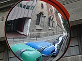 Català: Església i Convent de Pompeia. Av. Diagonal, 450 - c/ Riera de Sant Miquel, 1 (Barcelona).
This is a photo of a building indexed in the Catalan heritage register as Bé Cultural d'Interès Local (BCIL) under the reference 08019/2548.
Object location View all coordinates using: OpenStreetMap -
![]]. C. Còrsega, 311 - rambla Catalunya, 126 (Barcelona). This is a photo of a monument indexed in the Catalan heritage register of Béns Culturals d'Interès Nacional and the Spanish heritage register of Bienes de Interés Cultural under the reference RI-51-0010611. Object location 41° 23′ 44.48″ N, 2° 09′ 28.01″ E View all coordinates using: OpenStreetMap](https://upload.wikimedia.org/wikipedia/commons/thumb/c/cb/Casa_Serra_P1080799.jpg/90px-Casa_Serra_P1080799.jpg) ]]. C. Còrsega, 311 - rambla Catalunya, 126 (Barcelona).
]]. C. Còrsega, 311 - rambla Catalunya, 126 (Barcelona).
This is a photo of a monument indexed in the Catalan heritage register of Béns Culturals d'Interès Nacional and the Spanish heritage register of Bienes de Interés Cultural under the reference RI-51-0010611.
Object location View all coordinates using: OpenStreetMap -
 Català: Casa Pérez Samanillo (Círculo Ecuestre). C/ Balmes, 169-169 bis - av. Diagonal, 502-504 (Barcelona).
This is a photo of a building indexed in the Catalan heritage register as Bé Cultural d'Interès Local (BCIL) under the reference 08019/2198.
Object location View all coordinates using: OpenStreetMap -
 Català: Casa Sayrach. Av. Diagonal, 423-425 - c. Enric Granados, 157-159 (Barcelona).
This is a photo of a building indexed in the Catalan heritage register as Bé Cultural d'Interès Local (BCIL) under the reference 08019/1475.
Object location View all coordinates using: OpenStreetMap -
 Català: Casa Sayrach. C. Enric Granados, 153-155 (Barcelona).
This is a photo of a building indexed in the Catalan heritage register as Bé Cultural d'Interès Local (BCIL) under the reference 08019/1490.
Object location View all coordinates using: OpenStreetMap -
 Català: Casa Sayrach. Av. Diagonal, 423-425 - c. Enric Granados, 157-159 (Barcelona).
This is a photo of a building indexed in the Catalan heritage register as Bé Cultural d'Interès Local (BCIL) under the reference 08019/1475.
Object location View all coordinates using: OpenStreetMap -
 Català: Edifici d'habitatges Enric Granados - Diagonal - París. Av. Diagonal, 419-421 - c. Enric Granados, 120-126 - c. París, 207-209 (Barcelona).
This is a photo of a building indexed in the Catalan heritage register as Bé Cultural d'Interès Local (BCIL) under the reference 08019/1473.
Object location View all coordinates using: OpenStreetMap -
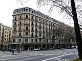 Català: Cases Almirall. Av. Diagonal, 433-439 - c. Aribau, 181 - c. Londres, 105-111 - c. Muntaner, 218-222 (Barcelona).
This is a photo of a building indexed in the Catalan heritage register as Bé Cultural d'Interès Local (BCIL) under the reference 08019/1476.
Object location View all coordinates using: OpenStreetMap -
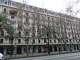 Català: Cases Almirall. Av. Diagonal, 433-439 - c. Aribau, 181 - c. Londres, 105-111 - c. Muntaner, 218-222 (Barcelona).
This is a photo of a building indexed in the Catalan heritage register as Bé Cultural d'Interès Local (BCIL) under the reference 08019/1476.
Object location View all coordinates using: OpenStreetMap -
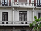 Català: Cases Almirall. Av. Diagonal, 433-439 - c. Aribau, 181 - c. Londres, 105-111 - c. Muntaner, 218-222 (Barcelona).
This is a photo of a building indexed in the Catalan heritage register as Bé Cultural d'Interès Local (BCIL) under the reference 08019/1476.
Object location View all coordinates using: OpenStreetMap -
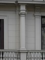 Català: Cases Almirall. Av. Diagonal, 433-439 - c. Aribau, 181 - c. Londres, 105-111 - c. Muntaner, 218-222 (Barcelona).
This is a photo of a building indexed in the Catalan heritage register as Bé Cultural d'Interès Local (BCIL) under the reference 08019/1476.
Object location View all coordinates using: OpenStreetMap -
 Català: Casa Parés de Plet. C/ Muntaner, 231 (Barcelona).
This is a photo of a building indexed in the Catalan heritage register as Bé Cultural d'Interès Local (BCIL) under the reference 08019/2340.
Object location View all coordinates using: OpenStreetMap -
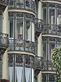 Català: Casa Parés de Plet. C/ Muntaner, 231 (Barcelona).
This is a photo of a building indexed in the Catalan heritage register as Bé Cultural d'Interès Local (BCIL) under the reference 08019/2340.
Object location View all coordinates using: OpenStreetMap -
 Català: Casa Parés de Plet. C/ Muntaner, 231 (Barcelona).
This is a photo of a building indexed in the Catalan heritage register as Bé Cultural d'Interès Local (BCIL) under the reference 08019/2340.
Object location View all coordinates using: OpenStreetMap -
 Català: El carrer Muntaner vist des de la Diagonal, amb la Casa Parés de Plet a l'esquerra. C/ Muntaner, 231 (Barcelona).
This is a photo of a building indexed in the Catalan heritage register as Bé Cultural d'Interès Local (BCIL) under the reference 08019/2340.
Object location View all coordinates using: OpenStreetMap -
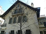 Català: ca:Casa Pere Company (actualment Museu de l'Esport). C. Casanova, 203 - c. Buenos Aires, 56 - 58 (Barcelona).
This is a photo of a building indexed in the Catalan heritage register as Bé Cultural d'Interès Local (BCIL) under the reference 08019/1398.
Object location View all coordinates using: OpenStreetMap -
![]]. C. Entença, 155 (Barcelona). This is a photo of a building indexed in the Catalan heritage register as Bé Cultural d'Interès Local (BCIL) under the reference IPA-41238. Object location 41° 23′ 00.54″ N, 2° 08′ 43.41″ E View all coordinates using: OpenStreetMap](https://upload.wikimedia.org/wikipedia/commons/thumb/0/07/Pres%C3%B3_model_P1080828.jpg/160px-Pres%C3%B3_model_P1080828.jpg) ]]. C. Entença, 155 (Barcelona).
]]. C. Entença, 155 (Barcelona).
This is a photo of a building indexed in the Catalan heritage register as Bé Cultural d'Interès Local (BCIL) under the reference IPA-41238.
Object location View all coordinates using: OpenStreetMap -
![]]. C. Entença, 155 (Barcelona). This is a photo of a building indexed in the Catalan heritage register as Bé Cultural d'Interès Local (BCIL) under the reference IPA-41238. Object location 41° 23′ 00.54″ N, 2° 08′ 43.41″ E View all coordinates using: OpenStreetMap](https://upload.wikimedia.org/wikipedia/commons/thumb/2/22/Pres%C3%B3_model_P1080829.jpg/160px-Pres%C3%B3_model_P1080829.jpg) ]]. C. Entença, 155 (Barcelona).
]]. C. Entença, 155 (Barcelona).
This is a photo of a building indexed in the Catalan heritage register as Bé Cultural d'Interès Local (BCIL) under the reference IPA-41238.
Object location View all coordinates using: OpenStreetMap -
![]]. C. Entença, 155 (Barcelona). This is a photo of a building indexed in the Catalan heritage register as Bé Cultural d'Interès Local (BCIL) under the reference IPA-41238. Object location 41° 23′ 00.54″ N, 2° 08′ 43.41″ E View all coordinates using: OpenStreetMap](https://upload.wikimedia.org/wikipedia/commons/thumb/1/1a/Pres%C3%B3_model_P1080830.jpg/160px-Pres%C3%B3_model_P1080830.jpg) ]]. C. Entença, 155 (Barcelona).
]]. C. Entença, 155 (Barcelona).
This is a photo of a building indexed in the Catalan heritage register as Bé Cultural d'Interès Local (BCIL) under the reference IPA-41238.
Object location View all coordinates using: OpenStreetMap -
![]]. C. Entença, 155 (Barcelona). This is a photo of a building indexed in the Catalan heritage register as Bé Cultural d'Interès Local (BCIL) under the reference IPA-41238. Object location 41° 23′ 00.54″ N, 2° 08′ 43.41″ E View all coordinates using: OpenStreetMap](https://upload.wikimedia.org/wikipedia/commons/thumb/0/08/Pres%C3%B3_model_P1080831.jpg/90px-Pres%C3%B3_model_P1080831.jpg) ]]. C. Entença, 155 (Barcelona).
]]. C. Entença, 155 (Barcelona).
This is a photo of a building indexed in the Catalan heritage register as Bé Cultural d'Interès Local (BCIL) under the reference IPA-41238.
Object location View all coordinates using: OpenStreetMap -
![]]. C. Entença, 155 (Barcelona). This is a photo of a building indexed in the Catalan heritage register as Bé Cultural d'Interès Local (BCIL) under the reference IPA-41238. Object location 41° 23′ 00.54″ N, 2° 08′ 43.41″ E View all coordinates using: OpenStreetMap](https://upload.wikimedia.org/wikipedia/commons/thumb/b/b7/Pres%C3%B3_model_P1080832.jpg/90px-Pres%C3%B3_model_P1080832.jpg) ]]. C. Entença, 155 (Barcelona).
]]. C. Entença, 155 (Barcelona).
This is a photo of a building indexed in the Catalan heritage register as Bé Cultural d'Interès Local (BCIL) under the reference IPA-41238.
Object location View all coordinates using: OpenStreetMap -
![]]. C. Entença, 155 (Barcelona). This is a photo of a building indexed in the Catalan heritage register as Bé Cultural d'Interès Local (BCIL) under the reference IPA-41238. Object location 41° 23′ 00.54″ N, 2° 08′ 43.41″ E View all coordinates using: OpenStreetMap](https://upload.wikimedia.org/wikipedia/commons/thumb/d/d2/Pres%C3%B3_model_P1080834.jpg/160px-Pres%C3%B3_model_P1080834.jpg) ]]. C. Entença, 155 (Barcelona).
]]. C. Entença, 155 (Barcelona).
This is a photo of a building indexed in the Catalan heritage register as Bé Cultural d'Interès Local (BCIL) under the reference IPA-41238.
Object location View all coordinates using: OpenStreetMap -
![]]. C. Entença, 155 (Barcelona). This is a photo of a building indexed in the Catalan heritage register as Bé Cultural d'Interès Local (BCIL) under the reference IPA-41238. Object location 41° 23′ 00.54″ N, 2° 08′ 43.41″ E View all coordinates using: OpenStreetMap](https://upload.wikimedia.org/wikipedia/commons/thumb/c/c7/Pres%C3%B3_model_P1080835.jpg/160px-Pres%C3%B3_model_P1080835.jpg) ]]. C. Entença, 155 (Barcelona).
]]. C. Entença, 155 (Barcelona).
This is a photo of a building indexed in the Catalan heritage register as Bé Cultural d'Interès Local (BCIL) under the reference IPA-41238.
Object location View all coordinates using: OpenStreetMap -
![]]. C. Entença, 155 (Barcelona). This is a photo of a building indexed in the Catalan heritage register as Bé Cultural d'Interès Local (BCIL) under the reference IPA-41238. Object location 41° 23′ 00.54″ N, 2° 08′ 43.41″ E View all coordinates using: OpenStreetMap](https://upload.wikimedia.org/wikipedia/commons/thumb/d/dc/Pres%C3%B3_model_P1080836.jpg/160px-Pres%C3%B3_model_P1080836.jpg) ]]. C. Entença, 155 (Barcelona).
]]. C. Entença, 155 (Barcelona).
This is a photo of a building indexed in the Catalan heritage register as Bé Cultural d'Interès Local (BCIL) under the reference IPA-41238.
Object location View all coordinates using: OpenStreetMap -
![]]. C. Entença, 155 (Barcelona). This is a photo of a building indexed in the Catalan heritage register as Bé Cultural d'Interès Local (BCIL) under the reference IPA-41238. Object location 41° 23′ 00.54″ N, 2° 08′ 43.41″ E View all coordinates using: OpenStreetMap](https://upload.wikimedia.org/wikipedia/commons/thumb/a/a0/Pres%C3%B3_model_P1080837.jpg/160px-Pres%C3%B3_model_P1080837.jpg) ]]. C. Entença, 155 (Barcelona).
]]. C. Entença, 155 (Barcelona).
This is a photo of a building indexed in the Catalan heritage register as Bé Cultural d'Interès Local (BCIL) under the reference IPA-41238.
Object location View all coordinates using: OpenStreetMap -
![]]. C. Entença, 155 (Barcelona). This is a photo of a building indexed in the Catalan heritage register as Bé Cultural d'Interès Local (BCIL) under the reference IPA-41238. Object location 41° 23′ 00.54″ N, 2° 08′ 43.41″ E View all coordinates using: OpenStreetMap](https://upload.wikimedia.org/wikipedia/commons/thumb/e/e9/Pres%C3%B3_model_P1080838.jpg/160px-Pres%C3%B3_model_P1080838.jpg) ]]. C. Entença, 155 (Barcelona).
]]. C. Entença, 155 (Barcelona).
This is a photo of a building indexed in the Catalan heritage register as Bé Cultural d'Interès Local (BCIL) under the reference IPA-41238.
Object location View all coordinates using: OpenStreetMap -
![]]. C. Entença, 155 (Barcelona). This is a photo of a building indexed in the Catalan heritage register as Bé Cultural d'Interès Local (BCIL) under the reference IPA-41238. Object location 41° 23′ 00.54″ N, 2° 08′ 43.41″ E View all coordinates using: OpenStreetMap](https://upload.wikimedia.org/wikipedia/commons/thumb/3/31/Pres%C3%B3_model_P1080839.jpg/160px-Pres%C3%B3_model_P1080839.jpg) ]]. C. Entença, 155 (Barcelona).
]]. C. Entença, 155 (Barcelona).
This is a photo of a building indexed in the Catalan heritage register as Bé Cultural d'Interès Local (BCIL) under the reference IPA-41238.
Object location View all coordinates using: OpenStreetMap -
![]]. Pl. Llibertat (Barcelona). This is a photo of a building indexed in the Catalan heritage register as Bé Cultural d'Interès Local (BCIL) under the reference 08019/2586. Object location 41° 23′ 59.46″ N, 2° 09′ 12.52″ E View all coordinates using: OpenStreetMap](https://upload.wikimedia.org/wikipedia/commons/thumb/d/d9/Mercat_de_la_Llibertat_P1080774.jpg/160px-Mercat_de_la_Llibertat_P1080774.jpg) ]]. Pl. Llibertat (Barcelona).
]]. Pl. Llibertat (Barcelona).
This is a photo of a building indexed in the Catalan heritage register as Bé Cultural d'Interès Local (BCIL) under the reference 08019/2586.
Object location View all coordinates using: OpenStreetMap -
![]]. Pl. Llibertat (Barcelona). This is a photo of a building indexed in the Catalan heritage register as Bé Cultural d'Interès Local (BCIL) under the reference 08019/2586. Object location 41° 23′ 59.46″ N, 2° 09′ 12.52″ E View all coordinates using: OpenStreetMap](https://upload.wikimedia.org/wikipedia/commons/thumb/3/3f/Mercat_de_la_Llibertat_P1080775.jpg/160px-Mercat_de_la_Llibertat_P1080775.jpg) ]]. Pl. Llibertat (Barcelona).
]]. Pl. Llibertat (Barcelona).
This is a photo of a building indexed in the Catalan heritage register as Bé Cultural d'Interès Local (BCIL) under the reference 08019/2586.
Object location View all coordinates using: OpenStreetMap
![]]. Plaça de Lesseps, 30-32 (Barcelona). This is a photo of a monument indexed in the Catalan heritage register of Béns Culturals d'Interès Nacional and the Spanish heritage register of Bienes de Interés Cultural under the reference RI-51-0010700. Object location 41° 24′ 22.54″ N, 2° 08′ 58.99″ E View all coordinates using: OpenStreetMap](/wiki/File:Cases_Ramos_P1080728.jpg)
![]]. Plaça de Lesseps, 30-32 (Barcelona). This is a photo of a monument indexed in the Catalan heritage register of Béns Culturals d'Interès Nacional and the Spanish heritage register of Bienes de Interés Cultural under the reference RI-51-0010700. Object location 41° 24′ 22.54″ N, 2° 08′ 58.99″ E View all coordinates using: OpenStreetMap](/wiki/File:Cases_Ramos_P1080729.jpg)
![]]. Plaça de Lesseps, 30-32 (Barcelona). This is a photo of a monument indexed in the Catalan heritage register of Béns Culturals d'Interès Nacional and the Spanish heritage register of Bienes de Interés Cultural under the reference RI-51-0010700. Object location 41° 24′ 22.54″ N, 2° 08′ 58.99″ E View all coordinates using: OpenStreetMap](/wiki/File:Cases_Ramos_P1080730.jpg)
![]]. Plaça de Lesseps, 30-32 (Barcelona). This is a photo of a monument indexed in the Catalan heritage register of Béns Culturals d'Interès Nacional and the Spanish heritage register of Bienes de Interés Cultural under the reference RI-51-0010700. Object location 41° 24′ 22.54″ N, 2° 08′ 58.99″ E View all coordinates using: OpenStreetMap](/wiki/File:Cases_Ramos_P1080731.jpg)
![]]. Plaça de Lesseps, 30-32 (Barcelona). This is a photo of a monument indexed in the Catalan heritage register of Béns Culturals d'Interès Nacional and the Spanish heritage register of Bienes de Interés Cultural under the reference RI-51-0010700. Object location 41° 24′ 22.54″ N, 2° 08′ 58.99″ E View all coordinates using: OpenStreetMap](/wiki/File:Cases_Ramos_P1080732.jpg)
![]]. Plaça de Lesseps, 30-32 (Barcelona). This is a photo of a monument indexed in the Catalan heritage register of Béns Culturals d'Interès Nacional and the Spanish heritage register of Bienes de Interés Cultural under the reference RI-51-0010700. Object location 41° 24′ 22.54″ N, 2° 08′ 58.99″ E View all coordinates using: OpenStreetMap](/wiki/File:Josepets_de_Gr%C3%A0cia_P1080736.jpg)
![]]. Plaça de Lesseps, 30-32 (Barcelona). This is a photo of a monument indexed in the Catalan heritage register of Béns Culturals d'Interès Nacional and the Spanish heritage register of Bienes de Interés Cultural under the reference RI-51-0010700. Object location 41° 24′ 22.54″ N, 2° 08′ 58.99″ E View all coordinates using: OpenStreetMap](/wiki/File:Cases_Ramos_P1080738.jpg)
![]]. Plaça de Lesseps, 30-32 (Barcelona). This is a photo of a monument indexed in the Catalan heritage register of Béns Culturals d'Interès Nacional and the Spanish heritage register of Bienes de Interés Cultural under the reference RI-51-0010700. Object location 41° 24′ 22.54″ N, 2° 08′ 58.99″ E View all coordinates using: OpenStreetMap](/wiki/File:Cases_Ramos_P1080739.jpg)


![]]. Plaça de Lesseps, 30-32 (Barcelona). This is a photo of a monument indexed in the Catalan heritage register of Béns Culturals d'Interès Nacional and the Spanish heritage register of Bienes de Interés Cultural under the reference RI-51-0010700. Object location 41° 24′ 22.54″ N, 2° 08′ 58.99″ E View all coordinates using: OpenStreetMap](/wiki/File:Cases_Ramos_P1080749.jpg)
![]]. Plaça de Lesseps, 30-32 (Barcelona). This is a photo of a monument indexed in the Catalan heritage register of Béns Culturals d'Interès Nacional and the Spanish heritage register of Bienes de Interés Cultural under the reference RI-51-0010700. Object location 41° 24′ 22.54″ N, 2° 08′ 58.99″ E View all coordinates using: OpenStreetMap](/wiki/File:Cases_Ramos_P1080750.jpg)
![]]. Plaça de Lesseps, 30-32 (Barcelona). This is a photo of a monument indexed in the Catalan heritage register of Béns Culturals d'Interès Nacional and the Spanish heritage register of Bienes de Interés Cultural under the reference RI-51-0010700. Object location 41° 24′ 22.54″ N, 2° 08′ 58.99″ E View all coordinates using: OpenStreetMap](/wiki/File:Cases_Ramos_P1080751.jpg)


![]]. C. Còrsega, 311 - rambla Catalunya, 126 (Barcelona). This is a photo of a monument indexed in the Catalan heritage register of Béns Culturals d'Interès Nacional and the Spanish heritage register of Bienes de Interés Cultural under the reference RI-51-0010611. Object location 41° 23′ 44.48″ N, 2° 09′ 28.01″ E View all coordinates using: OpenStreetMap](/wiki/File:Casa_Serra_P1080799.jpg)


![]]. C. Entença, 155 (Barcelona). This is a photo of a building indexed in the Catalan heritage register as Bé Cultural d'Interès Local (BCIL) under the reference IPA-41238. Object location 41° 23′ 00.54″ N, 2° 08′ 43.41″ E View all coordinates using: OpenStreetMap](/wiki/File:Pres%C3%B3_model_P1080828.jpg)
![]]. C. Entença, 155 (Barcelona). This is a photo of a building indexed in the Catalan heritage register as Bé Cultural d'Interès Local (BCIL) under the reference IPA-41238. Object location 41° 23′ 00.54″ N, 2° 08′ 43.41″ E View all coordinates using: OpenStreetMap](/wiki/File:Pres%C3%B3_model_P1080829.jpg)
![]]. C. Entença, 155 (Barcelona). This is a photo of a building indexed in the Catalan heritage register as Bé Cultural d'Interès Local (BCIL) under the reference IPA-41238. Object location 41° 23′ 00.54″ N, 2° 08′ 43.41″ E View all coordinates using: OpenStreetMap](/wiki/File:Pres%C3%B3_model_P1080830.jpg)
![]]. C. Entença, 155 (Barcelona). This is a photo of a building indexed in the Catalan heritage register as Bé Cultural d'Interès Local (BCIL) under the reference IPA-41238. Object location 41° 23′ 00.54″ N, 2° 08′ 43.41″ E View all coordinates using: OpenStreetMap](/wiki/File:Pres%C3%B3_model_P1080831.jpg)
![]]. C. Entença, 155 (Barcelona). This is a photo of a building indexed in the Catalan heritage register as Bé Cultural d'Interès Local (BCIL) under the reference IPA-41238. Object location 41° 23′ 00.54″ N, 2° 08′ 43.41″ E View all coordinates using: OpenStreetMap](/wiki/File:Pres%C3%B3_model_P1080832.jpg)
![]]. C. Entença, 155 (Barcelona). This is a photo of a building indexed in the Catalan heritage register as Bé Cultural d'Interès Local (BCIL) under the reference IPA-41238. Object location 41° 23′ 00.54″ N, 2° 08′ 43.41″ E View all coordinates using: OpenStreetMap](/wiki/File:Pres%C3%B3_model_P1080834.jpg)
![]]. C. Entença, 155 (Barcelona). This is a photo of a building indexed in the Catalan heritage register as Bé Cultural d'Interès Local (BCIL) under the reference IPA-41238. Object location 41° 23′ 00.54″ N, 2° 08′ 43.41″ E View all coordinates using: OpenStreetMap](/wiki/File:Pres%C3%B3_model_P1080835.jpg)
![]]. C. Entença, 155 (Barcelona). This is a photo of a building indexed in the Catalan heritage register as Bé Cultural d'Interès Local (BCIL) under the reference IPA-41238. Object location 41° 23′ 00.54″ N, 2° 08′ 43.41″ E View all coordinates using: OpenStreetMap](/wiki/File:Pres%C3%B3_model_P1080836.jpg)
![]]. C. Entença, 155 (Barcelona). This is a photo of a building indexed in the Catalan heritage register as Bé Cultural d'Interès Local (BCIL) under the reference IPA-41238. Object location 41° 23′ 00.54″ N, 2° 08′ 43.41″ E View all coordinates using: OpenStreetMap](/wiki/File:Pres%C3%B3_model_P1080837.jpg)
![]]. C. Entença, 155 (Barcelona). This is a photo of a building indexed in the Catalan heritage register as Bé Cultural d'Interès Local (BCIL) under the reference IPA-41238. Object location 41° 23′ 00.54″ N, 2° 08′ 43.41″ E View all coordinates using: OpenStreetMap](/wiki/File:Pres%C3%B3_model_P1080838.jpg)
![]]. C. Entença, 155 (Barcelona). This is a photo of a building indexed in the Catalan heritage register as Bé Cultural d'Interès Local (BCIL) under the reference IPA-41238. Object location 41° 23′ 00.54″ N, 2° 08′ 43.41″ E View all coordinates using: OpenStreetMap](/wiki/File:Pres%C3%B3_model_P1080839.jpg)
![]]. Pl. Llibertat (Barcelona). This is a photo of a building indexed in the Catalan heritage register as Bé Cultural d'Interès Local (BCIL) under the reference 08019/2586. Object location 41° 23′ 59.46″ N, 2° 09′ 12.52″ E View all coordinates using: OpenStreetMap](/wiki/File:Mercat_de_la_Llibertat_P1080774.jpg)
![]]. Pl. Llibertat (Barcelona). This is a photo of a building indexed in the Catalan heritage register as Bé Cultural d'Interès Local (BCIL) under the reference 08019/2586. Object location 41° 23′ 59.46″ N, 2° 09′ 12.52″ E View all coordinates using: OpenStreetMap](/wiki/File:Mercat_de_la_Llibertat_P1080775.jpg)