User:Rosemania/Maps
Old Maps
Most of the maps are old (over 70 years), huge, of China, and from the Library of Congress Map Collections. They will be updated regularly.
Beijing
edit-
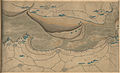
 1830-1870 wooden map
 -
 1848 vicinity Russian map
 -
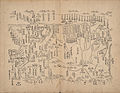
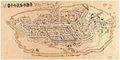
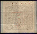 1861-1890 Inner city map
 -
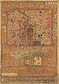
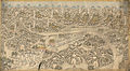
 1875 city map
 -
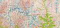
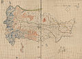
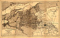 1874-1879 NW vicinity, Hebei Inner Mongolia
 -
 1875 vicinity German map
 -
 1878 vicinity German map, ref. Boxer Rebellion
 -
 1886 map showing vicinity and Nan Yuan
 -
 1900 French map - Beijing and Tianjin
 -
 1907 vicinity German map
 -
 1926 vicinity map, Great Britain War Office
 -
 Tongzhou 1926, Great Britain War Office
 -
 1986 CIA Map - Beijing and Tianjin
 -
 1900 Allied occupation after the Boxer Rebellion
 -
 1900 city map
 -
 1914 city map
 -
 1921 city map
 -
 1930 city map
 -
 1934 city map
 -
 1936 city map
 -
 1938 city map
 -
 1948 city map
 -
 1950 city map
 -
 1968 Public Transportation map, front
 -
 1968 Public Transportation map, back
 -
 Ancient Observatory
 -
 Legation District, 1903
 -
 Summer Palace, 1750-1887
 -
 Summer Palace, 1888
 -
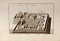
 Ming Tombs, 1757-1795
 -
 Ming Tombs, 1875-1908
 -
 Streetcar network, ca. 1950


Xinjiang
edit-
 Xinjiang 1759 - Cover
 -
 Xinjiang 1759 - 1 Overview
 -
 Xinjiang 1759 - 2 West of Jiayuguan
 -
 Xinjiang 1759 - 3 Kumul
 -
 Xinjiang 1759 - 4 Barköl
 -
 Xinjiang 1759 - 5 Qitai
 -
 Xinjiang 1759 - 6 Ürümqi
 -
 Xinjiang 1759 - 7 Lake Balkhash to Lake Zaysan
 -
 Xinjiang 1759 - 8 Turpan to Lop Nur
 -
 Xinjiang 1759 - 9 Korla
 -
 Xinjiang 1759 - 10 Kucha
 -
 Xinjiang 1759 - 11 Sayram to Toksun
 -
 Xinjiang 1759 - 12 Aksu
 -
 Xinjiang 1759 - 13 Uqturpan
 -
 Xinjiang 1759 - 14 Hotan
 -
 Xinjiang 1759 - 15 Yarkand
 -
 Xinjiang 1759 - 16 Kashgar
 -
 Xinjiang 1864
 -
 Xinjiang 1864, imperfect


Tibet
edit-
 Tibet 1900
 -
 Tibet 1904
 -
 Sven Hedin's expedition into Tibet, 1906-1908
 -
 Tibet 1955 CIA map
 -
 Mt Everest region, 1977 Soviet military map


China
edit-
 Kunyu Wanguo Quantu, 1602, by Matteo Ricci, left 3 panels
 -
 Kunyu Wanguo Quantu, 1602, by Matteo Ricci, right 3 panels
 -
 1710 Nanzenbushu Map
 -
 1800c Map of China and the World, front
 -
 1800c Map of China and the World, back
 -
 China and Asia, 1814-1816
 -
 China 1689-1722 Frontier - Aihun
 -
 China 1689-1722 Frontier - Russia
 -
 China 1689-1722 Frontier - Inner Mongolia
 -
 China 1689-1722 Frontier - Taiwan
 -
 China-Russia Frontier 1890 - Amur and Manchuria
 -
 China-Russia Frontier 1890 - West of Lake Baikal
 -
 China-Russia Frontier 1890 - Akmolinskaya
 -
 China-Russia Frontier 1890 - Pamir
 -
 China-Russia Frontier 1890 - Xinjiang
 -
 China-Russia Frontier 1890 - Beijing and Korea
 -
 China 1929
 -
 Asia countries 1932
 -
 China 1933
 -
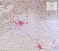
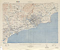
 Railroads in communist China, 1961
 -
 China: after three years of war, 1940
 -
 Chengde 1736-1774
 -
 Chengde 1875-1890
 -
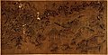
 Wutai Shan 1846
 -
 Hainan 1820-1875
 -
 Changchun, 1932 city plan 1
 -
 Changchun, 1932 city plan 2
 -
 Changchun, 1932 city plan 3
 -
 Changchun, 1932 city plan 4
 -
 Changchun, 1932 city plan 5
 -
 Changchun, 1932 city plan 6
 -
 Changchun, 1932 city plan 7
 -
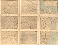
 Liaoning 1882 city plans 1
 -
 Liaoning 1882 city plans 2
 -
 Liaoning 1882 city plans 3
 -
 Liaoning 1882 city plans 4
 -
 Liaoning 1882 city plans 5
 -
 Tianjin 1899
 -
 Tianjin 1942
 -
 Qinhuangdao and Beidaihe, Hebei, 1908
 -
 Shanhaiguan, Hebei, 1908
 -
 Anyang 1900-1910
 -
 Laizhou 1800-1850
 -
 Xi'an 1893
 -
 Shanghai 1884, the International Settlement and French Concession
 -
 Shanghai vicinity, 1927
 -
 Shanghai 1935, NW
 -
 Shanghai 1935, central
 -
 Shanghai 1983 CIA map
 -
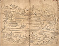 Hangzhou - West Lake 1759
 -
 Hangzhou - River Wave 1759
 -
 Hangzhou 1864-1874
 -
 Hangzhou Waterway 1864-1874
 -
 Hangzhou to Hanning, 1765-1772
 -
 Ningbo 1796-1820
 -
 Zhejiang 1773-1820 Qiantang
 -
 Zhejiang 1773-1820
 -
 Zhejiang 1904-1911
 -
 Wuhan 1864
 -
 Wuhan Hankow 1877
 -
 Wuhan Wuchang 1883
 -
 Chengdu 1989 CIA map
 -
 Xiamen, Fujian 1946, US Army Map Service


