User:Thisisbossi/gallery/15NOV2007
< User:Thisisbossi | gallery
Thu Nov 15 21:17:00 EST 2007 edit

Thu Nov 15 21:16:14 EST 2007 edit


Thu Nov 15 21:04:23 EST 2007 edit


Thu Nov 15 20:55:37 EST 2007 edit


Thu Nov 15 20:53:39 EST 2007 edit


Thu Nov 15 20:50:51 EST 2007 edit


Thu Nov 15 20:45:15 EST 2007 edit

Thu Nov 15 20:43:16 EST 2007 edit


Thu Nov 15 20:38:17 EST 2007 edit


Thu Nov 15 20:36:36 EST 2007 edit


Thu Nov 15 20:14:53 EST 2007 edit


Thu Nov 15 20:05:57 EST 2007 edit


Thu Nov 15 20:02:40 EST 2007 edit


Thu Nov 15 19:57:31 EST 2007 edit
-

Camera location 

View all coordinates using: OpenStreetMap 
-

Camera location View all coordinates using: OpenStreetMap -

Camera location View all coordinates using: OpenStreetMap


Thu Nov 15 19:52:52 EST 2007 edit


Thu Nov 15 19:49:19 EST 2007 edit


Thu Nov 15 19:42:37 EST 2007 edit
-
 English: MD 187 (Old Georgetown Road) at West Cedar Lane, Bethesda, MD, USA
Camera location 
View all coordinates using: OpenStreetMap -
 English: The National Institutes of Health, Bethesda, MD, USA
Camera location 
View all coordinates using: OpenStreetMap


Thu Nov 15 19:33:31 EST 2007 edit


Thu Nov 15 19:20:51 EST 2007 edit


Thu Nov 15 19:11:29 EST 2007 edit


Thu Nov 15 19:05:59 EST 2007 edit

Thu Nov 15 18:48:01 EST 2007 edit


Thu Nov 15 18:34:30 EST 2007 edit


Thu Nov 15 18:29:50 EST 2007 edit

Thu Nov 15 18:27:32 EST 2007 edit


Thu Nov 15 18:26:33 EST 2007 edit


Thu Nov 15 18:24:10 EST 2007 edit

Thu Nov 15 18:18:46 EST 2007 edit
-
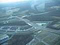
 English: MD 121 (Clarksburg Road), the diagonal road from bottom-right to the interchange at top-left, where it continues to the horizon. From the interchange toward the bottom-left is Stringtown Road. These roads interchange with I-270, which runs left to right, toward the top. The left-right roadway toward the bottom is MD 355. Clarksburg, MD, USA
Camera location 
View all coordinates using: OpenStreetMap -
 English: Stringtown Road runs from through the center from the bottom to the interchange near the top, where it continues on as MD 121 (Clarksburg Road) to the horizon. MD 121 splits toward the center-right, generally hidden behind trees. These roads interchange with I-270, which runs left to right, toward the top. The left-right roadway at the bottom is MD 355. Clarksburg, MD, USA
Camera location View all coordinates using: OpenStreetMap


Thu Nov 15 17:59:17 EST 2007 edit
-
Camera location 
View all coordinates using: OpenStreetMap -

Camera location View all coordinates using: OpenStreetMap


