User:Threedots/Graphics and Maps
All graphics and maps are made with Adobe Photoshop, Corel Draw or Gimp. They are licensed under the GNU FDL and CC-by-sa-2.0-de. Well, that means they are not mine but ours - ask for a .psd- / .xcf-file or tell me what should be changed, added, corrected or if you need another language version.
-
 Map of the Ruhr Area, Germany
 -
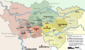 Administration of the Ruhr Area, Germany
 -
 Symbol of Mining (german: "Schlägel und Eisen")
 -
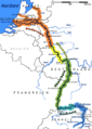 Map of the european river rhine
 -
 Map of the european river danube
 -
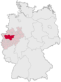 Position of the Ruhr Area in Germany
 -
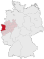 Position of the region "Niederrhein" in Germany
 -
 coat of arms of Dorsten
 -
 the Niederrhein region
 -
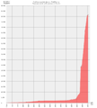 Population statistics of Dorsten
 -
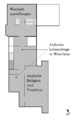
 Jewish museum westphalia
 -

-
-
 Castle Raesfeld
 -
 Grenzlandring
 -
 coal mine König Ludwig, Recklinghausen
 -
 Kreis Recklinghausen COA


