User:Zde/Mycenae
Archaeological sites of Mycenae
General views
edit5000 to 200 BC, mostly visible is Late Bronze Age


Main Archaeological site
edit| Object location | | View all coordinates using: OpenStreetMap |
|---|
In order according to the progress of the trip, although at the cost of turns.
-
 The entrance
 -

-
 Cyclopean walls
 -
 Before Lion Gate


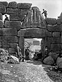
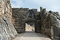
Lion Gate
edit| Object location | | View all coordinates using: OpenStreetMap |
|---|
1250 BC
-
 1822
1822 -
 1898
1898 -
 2020
2020 -
-

-
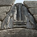 Relief
 -

-
 From the inside
 -

-

-

-

-
 North quarter above the Lion Gate
 -
 North quarter above the Lion Gate
_p192_THE_LION%27S_GATE_AT_MYCEN%C3%86.jpg)


.jpg)


Grave Circle A
edit| Object location | | View all coordinates using: OpenStreetMap |
|---|
16th-century BC royal cemetery
-
 Model
Model -

-

-

-

-

-
-

-


.jpg)


Behind the Grave Circle A
editBetween the main way and the southern walls
-

-
 House of the Warrior Krater
 -

-

-

-

-


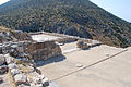
From Great ramp to Palace
editAround the main way through the area


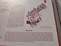
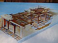
Royal Palace
edit| Object location | | View all coordinates using: OpenStreetMap |
|---|
13th century BC, on the site of the center from the 3rd millennium BC
-
-
-

-

-
-

-

-

-

-
 Fireplace


Northeast extension
edit= Eastern part of main area


.jpg)

Eastern gate
edit= Northeastern gate. According to legend, this way Orestes fled, when he killed the treacherous Klytaimnestre and Aigisthos.
_-_%CE%91%CE%BD%CF%84%CE%B9%CE%B3%CF%81%CE%B1%CF%86%CE%AE.jpg)


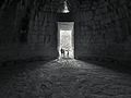
Great cistern
edit| Camera location | | View all coordinates using: OpenStreetMap |
|---|
Underground cistern, 99 steps to a cistern carved out of rock
-

-

-

-

-

-

-

-
 Bottom
 -

-


From cistern to North gate
edit
.jpg)


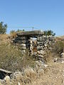
North gate
edit| Object location | | View all coordinates using: OpenStreetMap |
|---|
= Postern gate
From the outside
edit


From the inside
edit


Lion Tomb
editIn front of the Archaeological Museum
| Object location | | View all coordinates using: OpenStreetMap |
|---|


West part of area
editNear the access road, before (below) the Lion Gate
-

-
 House of Oil Merchant
 -


_in_Mycenae.jpg)

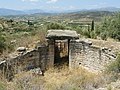
Tomb of Aegisthus
edit| Object location | | View all coordinates using: OpenStreetMap |
|---|


_at_Mycenae_on_26_March_2019.jpg)
.jpg)


.jpg)
Tomb of Clytemnestra
edit| Object location | | View all coordinates using: OpenStreetMap |
|---|
1250 BC was the last tomb of this type in the region
-

-

-

-
 Hellenistic theatre
 -

-


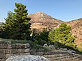
Grave Circle B
edit| Object location | | View all coordinates using: OpenStreetMap |
|---|
Mostly 17th–16th century BC Royal cemetery situated outside the Late Bronze Age citadel of Mycenae


Treasury of Atreus
edit| Object location | | View all coordinates using: OpenStreetMap |
|---|
1250 BC, the stone lintel above the doorway weighs 120 tons, with dimensions 8.3 x 5.2 x 1.2 m
-
 1843
1843 -
-

-

-

-

-

-

-

-

-

-


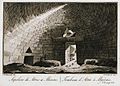
Interior
editInterior height of 13.5 m and a diameter of 14.5 m
-
 1820
1820 -
-

-

-

-

-

-


Burial chamber
edit


Other Tombs
editOutside the main area
-
 Tomb of Epano Phournos
 -
 Tomb of Kato Phournos
 -
 Tomb of Genii
 -
 Tomb of Genii


Contemporary Mykines
edit-
 Schliemann house
 -

-

-
 Tomb of G. E. Mylonas


