User:Zde/Nemea
< User:Zde
Nemea: Archaeological sites and vinery
Main Archaeological site
edit| Object location | | View all coordinates using: OpenStreetMap |
|---|
Coordinates of the entrance to the area with the Temple of Zeus
See also Archaeological Museum of Nemea.
-
 Model, state of the year 300 BC
 -
 Early 19th century
 -
 1843
1843 -
 View from the entrance
 -
 Plan
Plan


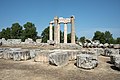
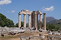
Temple of Zeus
edit| Object location | | View all coordinates using: OpenStreetMap |
|---|
The Temple of Nemean Zeus, 330 BC on the site of an older temple (410 BC).
-
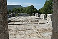
 Oikoi (ancient houses) and the Temple
 -
-

-
-

-

-

-

-

-

-

-

-

-

-
-

-

-

-

-

-

-


,_Nemea_(17806583354).jpg)
,_Nemea_(14065551534).jpg)


Findings from the Temple
editIncluding finds from the older temple
-
 410 BC
 -
 400-350 BC
 -

-


Near the Temple
edit-
 Foundations for sanctuary groups
 -

-
 Sacred grove of cypress trees, and columns
 -
 Sacred grove of cypress trees
 -

-
 The northern edge of the area


Reconstruction
edit| Object location | | View all coordinates using: OpenStreetMap |
|---|
Exhibition of the reconstruction


Bath
edit| Object location | | View all coordinates using: OpenStreetMap |
|---|
Hellenistic bath, or rather bathrooms


Sanctuary of Ofeltes
edit| Object location | | View all coordinates using: OpenStreetMap |
|---|
English: Hero shrine of Opheltes at Nemea. The visible remains date back to Hellenistic times. Findings are from the late 6th century BC to the early 3rd century BC. See Pausanias II, 15, 3.
Čeština: Svatyně princátka Ofeltea v roli héroa. Viditelné zbytky pocházejí z helénistické doby. Nalezené památky jsou od pozdního 6. století před n. l. po rané 3. století před n. l. Viz Pausaniás, Cesta po Řecku (2 století n. l.) II, 15, 3: "Kolem chrámu je cypřišový háj a tam prý jednou chůva odložila Ofelta do trávy a toho pak usmrtil had... Tam je také Ofeltův hrob, kolem něho zídka z kamenů a uvnitř okrsku oltáře. Je tu také nasypaná mohyla, památník Lykúrga, otce Ofeltova" (př. H. Businská)
-
 in 2020
 -

-

-

-
 SW corner in 1991
 -


Findings from Sanctuary of Ofeltes
edit-
 Hypsipyle and Opheltes, 500 BC
 -
 Opheltes
 -
 Small Gold-foil mask
 -
 Hellenistic Opheltes
 -
 Small bronze head of lion
 -
 Miniature pottery
 -

-
 Lead curse tablets
 -
 Course inscription
 -
 In the AM of Nemea


Stadium site
edit| Object location | | View all coordinates using: OpenStreetMap |
|---|
Coordinates of the entrance


Apodyterium
edit| Object location | | View all coordinates using: OpenStreetMap |
|---|
The athletes' locker room and also the place where they were painted with oil.


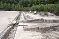
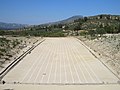
Stadium
edit| Object location | | View all coordinates using: OpenStreetMap |
|---|
Stadium of the Nemean games, ca 320 BC
-

-

-
 Inscription, ca 100 AD
 -

-

-

-
-
 Start line
 -

-

-

-

-

-


.jpg)
.jpg)


.jpg)


.jpg)

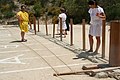
Start and Hysplex
edit-

-
 In 2004, start line
 -
 Reconstruction
 -

-
-


.jpg)
.jpg)
.jpg)
Archaia Nemea and winery
edit| Object location | | View all coordinates using: OpenStreetMap |
|---|
The contremporary village of Archaia Nemea


Viticulture
edit-
 Vine tree near Archeological site
 -
 Agiorgitiko grape variety
 -

-


