Ле Лой
|
|

Welcome, Dear Filemover! edit

Hi Ле Лой, you're now a filemover. When moving files please respect the following advice:
- Use the CommonsDelinker link in the {{Rename}} template to order a bot to replace all ocurrences of the old title with the new one. Or, if there was no rename-request, please use the Move & Replace-tab.
- Please leave a redirect behind unless you have a valid reason not to do so. Other projects, including those using InstantCommons, might be using the file even though they don't show up in the global usage. Deleting the redirects would break their file references. Please see this section of the file rename guideline for more information.
- Please know and follow the file rename guidelines.
--Steinsplitter (talk) 10:52, 23 July 2015 (UTC)
- Thank you very much! Ле Лой (talk) 11:17, 23 July 2015 (UTC)
感謝 edit
- はじめまして、mtiです。このたびはお忙しい中、感謝のメッセージをありがとうございます。これからもЛе Лойさんの御活躍をお祈りします。--Mti (talk) 13:49, 28 July 2015 (UTC)
- はじめまして、Mtiさん。こちらこそ有難うございます。 Ле Лой (talk) 22:35, 28 July 2015 (UTC)
Tikal map edit
Hi Ле Лой, thanks for the new version of the Tikal map, it is a great improvement on the map I did - just one minor point - the North Acropolis is marked as "Northern Acropolis", a term that is never used in reliable sources. Would it be possible for you to change it? Best regards, Simon Burchell (talk) 08:35, 13 August 2015 (UTC)
- Hi, fixed. Thank you very much for correction :) Let me know if anything else comes to your mind! Ле Лой (talk) 08:46, 13 August 2015 (UTC)
- That was quick! Many thanks, Simon Burchell (talk) 08:48, 13 August 2015 (UTC)
メッセージありがとうございます edit
- Ле Лойさん、こんにちは。mtiです。このたびはメッセージをありがとうございます。わたくしは今後もあなたの活躍をお祈りいたします。--Mti (talk) 12:19, 15 September 2015 (UTC)
- mtiさん、こちらこそ本当にいつもお世話になっております。 — Le Loi (talk) 22:23, 15 September 2015 (UTC)
Flag of Friuli-Venezia Giulia edit
Can you convert Can you convert ![]() to SVG? Thanks. 174.113.217.132 18:37, 20 September 2015 (UTC)
to SVG? Thanks. 174.113.217.132 18:37, 20 September 2015 (UTC)
- Hi, I’ll try, but that’s a complex one, so it is going to take some time :) — Le Loi (talk) 00:03, 21 September 2015 (UTC)
お願い edit
- Ле Лойさん、こんにちは。mtiです。いつもお世話になっております。大変失礼ですが、いつもsvg画像をアップされているということでお得意かと思いますが、svgに変換することはできますでしょうか?
- してほしいsvg化
 (長浜市章)
 (守山市章)
 (栗東市章)
 (甲賀市章)
- してほしいsvg化


- お忙しいところ承知ですが、お願いいたします。--Mti (talk) 12:56, 21 September 2015 (UTC)
- mtiさん、今日は!svgに変換することを終わりまして。宜しくお願いします。— Le Loi (talk) 03:16, 22 September 2015 (UTC)
- ありがとうございます。お忙しい中、ご協力していただきありがとうございます。日々精力的にsvg化に精進しているЛе Лойさんに感謝いたします。さて、こちらの追加のsvgもお願いできますでしょうか?
 (彦根市章)
 (栗東市旗)
 (竜王町章)
 (豊郷町旗)
 (豊郷町章)
 (多賀町旗)

お忙しいところ、承知ですが、またお願いいたします。--Mti (talk) 03:38, 23 September 2015 (UTC)

|
Commons:Deletion requests/File:Pablo Escobar graffitti.jpg has been listed at Commons:Deletion requests so that the community can discuss whether it should be kept or not. We would appreciate it if you could go to voice your opinion about this at its entry.
If you created this project page, please note that the fact that it has been proposed for deletion does not necessarily mean that we do not value your kind contribution. It simply means that one person believes that there is some specific problem with it. |
Amnesico29 (talk) 23:50, 23 September 2015 (UTC)
Stefan4 (talk) 21:47, 30 September 2015 (UTC)
- Hi from 2012 :) It’s already fixed by the bot. — Le Loi (talk) 05:25, 1 October 2015 (UTC)
|
|
File:Nước mắm bottle.JPG has been listed at Commons:Deletion requests so that the community can discuss whether it should be kept or not. We would appreciate it if you could go to voice your opinion about this at its entry.
If you created this file, please note that the fact that it has been proposed for deletion does not necessarily mean that we do not value your kind contribution. It simply means that one person believes that there is some specific problem with it, such as a copyright issue. Please see Commons:But it's my own work! for a guide on how to address these issues. |
Просьба на создание векторных изображений edit
Здравствуйте.
Совершенно случайно увидел вашу страницу, и в частности, то, что вы преобразуете растровую графику в векторную, и поэтому решил к вам обратиться за помощью.
1) помогите пожалуйста преобразовать два растровых изображения (два цветочка) в векторные, в большой картинке File:RFremix logo.svg
Разумеется я и сам пробовал преобразовать цветы в вектор, но видимо, из-за маленького разрешения, получалось всё очень плохо. Поэтому я загрузил картинку в которой остались два растра. Может быть вы подскажете где есть такие цветы в большем разрешении, или быть может даже в векторе?
2) ещё одна маленькая просьба. Если у вас будет время, не могли бы вы преобразовать растровые изображения гербов и флагов некоторых населённых пунтов в векторные? Пусть векторные изображения содержат часть растровых, всё равно это будет лучше, и в последующем будет проще доделать их до 100 процентого векторного изображения. В частности я имею ввиду следующие картинки: File:Dnestrovsk flag.GIF, File:Dnestrovsk gerb.gif, File:Flag of Rybnitsa.png, File:Ribnita-gerb.png, File:Bendery-Flag-2003b.png, File:Stema municipiu Tighina.jpg.
-- С уважением, Донор (✉) 28 марта 2016
- Здравствуйте, я постараюсь векторизировать сколько смогу, но ввиду занятости в реале процесс может затянуться, так что возможно имеет смысл оставить заявку в мастерской. — Le Loi (talk) 22:01, 28 March 2016 (UTC)
- Спасибо за ссылку на Графичекую мастерскую. Оставил и там заявку. -- С уважением, Донор (✉) 29 марта 2016
- @Ле Лой: , Христос Воскресе! Извините что опять решил вас потревожить. Я поправил вашу картинку: File:Ryukyu cultural regions.svg, а также на вашей странице установил более правильную ссылку. А теперь собственно говоря сам вопрос. Возьмём для примера мой файл: File:Переливание крови.svg, обратите внимание на его первую версию. Там виден маленький чёрный квадратик. Однако в Inkscape этот квадрат совершенно не виден. Поэтому подскажите как его можно удалить, или как сделать так, что бы он стал виден в Inkscape. Возможно вы уже сталкивались с подобными вещами, ибо на викискладе полным полно примеров SVG файлов, в истории которых видны чёрные фоны. Если вы поделитесь ссылкой на статью как удалить такой чёрный фон, то я буду очень признателен. -- С уважением, Донор (✉) 2 мая 2016
- Здравствуйте, спасибо, я немного забегался с той картинкой, хорошо, что вы исправили. Я пользуюсь CorelDraw, а не Inkscape, потому как исправлять проблемы последнего не особенно знаю. Судя по всему, это вот что. — Le Loi (talk) 10:23, 2 May 2016 (UTC)
- @Ле Лой: , спасибо! Ваши ссылки мне очень помогли. Жаль что там на английском, поэтому я не сразу догадался что означает слово Deselect. Если у кого то из пользователей возникнут аналогичные проблемы, то я оставлю здесь маленькую инструкцию на русском как избавиться от этих чёрных квадратов. Итак, 1) открываем файл с чёрным квадратом в Inkscape; 2) нажимаем на вкладку Правка и в выпавшем списке выбираем пункт Снять выделение; 3) затем нужно ввести текст, я для этого выбрал в левом столбце кнопку с текстом; 4) кликаем где-нибудь на изображении для ввода текста, но сам текст вводить не нужно; 5) нажимаем на кнопку Tab, и перемещаясь по выделяемым объектам, ищем наш невидимый чёрный квадрат; 6) когда чёрный квадрат найден, то удаляем его, например кликаем правой кнопкой мышки и выбираем пункт Удалить. Всё. -- С уважением, Донор (✉) 3 мая 2016
- Здравствуйте, спасибо, я немного забегался с той картинкой, хорошо, что вы исправили. Я пользуюсь CorelDraw, а не Inkscape, потому как исправлять проблемы последнего не особенно знаю. Судя по всему, это вот что. — Le Loi (talk) 10:23, 2 May 2016 (UTC)
- @Ле Лой: , Христос Воскресе! Извините что опять решил вас потревожить. Я поправил вашу картинку: File:Ryukyu cultural regions.svg, а также на вашей странице установил более правильную ссылку. А теперь собственно говоря сам вопрос. Возьмём для примера мой файл: File:Переливание крови.svg, обратите внимание на его первую версию. Там виден маленький чёрный квадратик. Однако в Inkscape этот квадрат совершенно не виден. Поэтому подскажите как его можно удалить, или как сделать так, что бы он стал виден в Inkscape. Возможно вы уже сталкивались с подобными вещами, ибо на викискладе полным полно примеров SVG файлов, в истории которых видны чёрные фоны. Если вы поделитесь ссылкой на статью как удалить такой чёрный фон, то я буду очень признателен. -- С уважением, Донор (✉) 2 мая 2016
- Спасибо за ссылку на Графичекую мастерскую. Оставил и там заявку. -- С уважением, Донор (✉) 29 марта 2016
|
|
File:Biwa statue from Rinku.jpg has been listed at Commons:Deletion requests so that the community can discuss whether it should be kept or not. We would appreciate it if you could go to voice your opinion about this at its entry.
If you created this file, please note that the fact that it has been proposed for deletion does not necessarily mean that we do not value your kind contribution. It simply means that one person believes that there is some specific problem with it, such as a copyright issue. Please see Commons:But it's my own work! for a guide on how to address these issues. |
|
|
File:Mother of pearl biwa.jpg has been listed at Commons:Deletion requests so that the community can discuss whether it should be kept or not. We would appreciate it if you could go to voice your opinion about this at its entry.
If you created this file, please note that the fact that it has been proposed for deletion does not necessarily mean that we do not value your kind contribution. It simply means that one person believes that there is some specific problem with it, such as a copyright issue. Please see Commons:But it's my own work! for a guide on how to address these issues. |
 |
File:Lõõtspill 1.jpg has been marked as a possible copyright violation. Wikimedia Commons only accepts free content—that is, images and other media files that can be used by anyone, for any purpose. Traditional copyright law does not grant these freedoms, and unless noted otherwise, everything you find on the web is copyrighted and not permitted here. For details on what is acceptable, please read Commons:Licensing. You may also find Commons:Copyright rules useful, or you can ask questions about Commons policies at the Commons:Help desk. If you are the copyright holder and the creator of the file, please read Commons:But it's my own work! for tips on how to provide evidence of that.
The file you added has been deleted. If you have written permission from the copyright holder, please have them send us a free license release via COM:VRT. If you believe that the deletion was not in accordance with policy, you may request undeletion. (It is not necessary to request undeletion if using VRT; the file will be automatically restored at the conclusion of the process.) Warning: Wikimedia Commons takes copyright violations very seriously and persistent violators will be blocked from editing.
|
Also:
Reminder: Round 2 of Picture of the Year 2016 is open! edit

You are receiving this message because you voted in R1 of the 2016 Picture of the Year contest.
Dear Ле Лой,
Wikimedia Commons is happy to announce that the second round of the 2016 Picture of the Year competition is now open. This year will be the eleventh edition of the annual Wikimedia Commons photo competition, which recognizes exceptional contributions by users on Wikimedia Commons. Wikimedia users are invited to vote for their favorite images featured on Commons during the last year (2016) to produce a single Picture of the Year.
Hundreds of images that have been rated Featured Pictures by the international Wikimedia Commons community in the past year were entered in this competition. These images include professional animal and plant shots, breathtaking panoramas and skylines, restorations of historical images, photographs portraying the world's best architecture, impressive human portraits, and so much more.
There are two total rounds of voting. In the first round, you voted for as many images as you liked. In Round 1, there were 1475 candidate images. There are 58 finalists in Round 2, comprised of the top 30 overall as well as the top #1 and #2 from each sub-category.
In the final round, you may vote for just one or maximal three image to become the Picture of the Year.
Round 2 will end on 20 April 2017, 23:59:59 UTC.
Thanks,
--Wikimedia Commons Picture of the Year committee 08:41, 16 April 2017 (UTC)
|
|
File:春の海 (宮城道雄と吉田晴風).ogg has been listed at Commons:Deletion requests so that the community can discuss whether it should be kept or not. We would appreciate it if you could go to voice your opinion about this at its entry.
If you created this file, please note that the fact that it has been proposed for deletion does not necessarily mean that we do not value your kind contribution. It simply means that one person believes that there is some specific problem with it, such as a copyright issue. Please see Commons:But it's my own work! for a guide on how to address these issues. |
Плоская Земля edit
Здравствуйте, уважаемый Ле Лой, а также @Kaidor: и @Hellerick: .
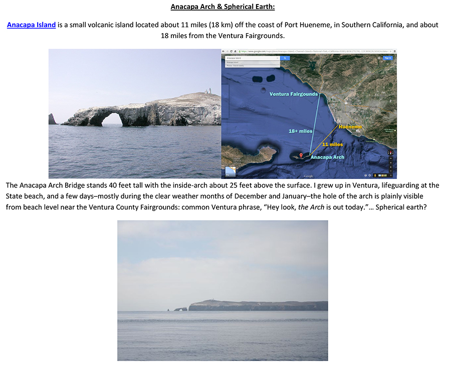
Обращаюсь сразу к трём отличным специалистам в векторной графике. Я тоже иногда рисую, но мои навыки на начальном уровне. Однако, даже их мне достаточно для того чтобы нарисовать круг диаметром 127000 км и провести касательную. В общем, в чём суть вопроса. Сегодня я обратился к участнику Dennis Bratland. В первом комментарии, который и остался, я сказал что есть очень интересное видео Flat Earth 31.63 miles.Undeniable Proof.
В этом видеоролике оператор стоит на пляже в Санта-Монике и снимает на видео острова Анакапа. Но изюминка заключается в том, что если Земля шарообразная, то двух из трёх островов наблюдатель просто не мог бы видеть! Но на видео они прекрасно видны. В качестве наглядного инструмента для измерения кривизны Земли я дал ссылку на он-лайн калькулятор.
Вот я и попросил его чтобы он, или кто-либо другой из активных пользователей английский википедии или Викисклада проживающие в Калифорнии сфотографировали эти острова. Таким образом можно было бы либо подтвердить, либо опровергнуть теорию Плоской Земли.
Dennis Bratland ответил мне, что эта геометрическая ошибка объясняется здесь.
Разумеется я возмутился и нарисовал в векторе прямую линию от пляжа в Санта-Монике до островов Анакапа. Но в чертеже специально сделал две ошибки:
1) во-первых: я нарисовал что наблюдатель находится на высоте 10-ть метров! В то время как на видео фотоаппарат находится на высоте 1 метр, а то и вовсе прямо у воды!
2) во вторых: касательная даже слегка утоплена в воде.
В результате, исходя из чертежа, я получил что на дальности 50 км (дальность до островов) будет скрыто от наблюдателя целых 100 метров высоты. Это при том что наблюдатель стоит на пляже в Санта-Монике на высоте 10 метров. Таким образом двух островов вообще не должно быть видно! Но они видны. Я даже дал ссылку на не менее интересную картинку этих же островов, а точнее арки. Мне показалось что будет просто великолепно если кто то из Калифорнийцев съездит туда и сфотографирует эти острова с разных высот и с разных мест.
Однако, кто-то, возможно что и Dennis Bratland, предпочёл просто удалить мой второй комментарий и закрыть тему.
Вот у меня и возник вопрос.
Скажите пожалуйста уважаемые графисты @Ле Лой: , @Kaidor: и @Hellerick: , что же я неправильно нарисовал?
Вот мой векторный рисунок: File:Anacapa-island-map-Proofs-the-Earth-is-Flat.svg
Скажите пожалуйста правильно ли я его нарисовал?
Может быть у меня кривые руки или я вообще слепой?
Ведь, рисунок подтверждает правильность вычислений калькулятора.
У меня просто нет слов. Я провожу прямую линию, измеряю высоту, а мой комментарий/ответ просто удаляется и тема закрывается… Как так можно? А ведь я всего-лишь просил сфотографировать острова. Ведь они могли бы там провести вики-экспедицию. Сделать кучу снимков, снять видео…
В общем, скажите пожалуйста что вы думаете о моём чертеже, который я представил выше?
Может быть у вас получится создать более красивый чертёж?
— С уважением, Донор (✉) 18:15, 25 октября 2017 (UTC).
- Здравствуйте, Донор! Я, признаться, не понял, что изображено на данном рисунке. Не могли бы вы пояснить? — Le Loy (talk) 04:24, 30 October 2017 (UTC)
- Откройте данный svg рисунок в программе для работы с векторной графикой и вы заметите что та часть которая отображается в браузере является всего-лишь фрагментом огромного чертежа. Максимально увеличив участок на самом верху рисунка вы увидите условно обозначенный берег Калифорнии и отложенную от него дальность в 50 км. Также на рисунке виден объект высотой 10-ть метров (высота нахождения глаза наблюдателя) и проведённая от него касательная к окружности. На определённой дальности касательная касается круга (поверхности океана), после чего начинается невидимая зона. Которая увеличивается с увеличением дальности, и на расстоянии 50 км составляет около 100 метров. Таким образом данный чертёж подтверждает правильность вычислений этого калькулятора. Вот я и прошу вас проверить правильность построения чертежа. Или, если у вас получится и будет время, то может быть создать более красивый и наглядный чертёж. Я бы не стал вас тревожить, но англоязычный участник сказал мне что это геометрическая ошибка. Но какая же это может быть геометрическая ошибка, если даже на чертеже всё прекрасно видно, и чертёж подтверждает правильность вычислений калькулятора. — Донор (✉) 05:15, 30 октября 2017 (UTC).
- Донор, на вашей картинке с геометрией всё правильно, однако она не учитывает преломление в атмосфере, которое при горизонтальных наблюдениях достигает около 0,5°. А насчёт видео — не очень понимаю, зачем автор вставил сравнение фотографий, сделанных на разной высоте, потому что явно заметно, что с высоты видно бо́льшую часть острова, что не может быть объяснено, если бы земля была бы плоской. — Le Loy (talk) 09:42, 30 October 2017 (UTC)
- Большое спасибо. Тогда, не могли бы вы загрузить новую версию рисунка где бы касательная к окружности была бы проведена идеально точно и был учтён угол 0,5°. Мне просто интересно, какой результат получится на дальности в 31 милю. — Донор (✉) 11:05, 30 октября 2017 (UTC).
- Донор, делать новую версию смысла нет: на 50км 35 минут превращаются в 500м ([1]), что с лихвой покрывает кривизну Земли. — Le Loy (talk) 03:26, 31 October 2017 (UTC)
- Ого-го! Вот это искажение. Но тогда это явно не геометрическая ошибка, как уверял меня американец, а оптическая, вызванная преломлением света. Эх, даже жалко. Вот была бы сенсация если бы Земля оказалась бы Плоской
 ! Тогда, если у вас есть право удаления фотографий, то удалите пожалуйста мой чертёж с Викисклада. — Донор (✉) 06:58, 31 октября 2017 (UTC).
- Ого-го! Вот это искажение. Но тогда это явно не геометрическая ошибка, как уверял меня американец, а оптическая, вызванная преломлением света. Эх, даже жалко. Вот была бы сенсация если бы Земля оказалась бы Плоской
- Донор, делать новую версию смысла нет: на 50км 35 минут превращаются в 500м ([1]), что с лихвой покрывает кривизну Земли. — Le Loy (talk) 03:26, 31 October 2017 (UTC)
- Большое спасибо. Тогда, не могли бы вы загрузить новую версию рисунка где бы касательная к окружности была бы проведена идеально точно и был учтён угол 0,5°. Мне просто интересно, какой результат получится на дальности в 31 милю. — Донор (✉) 11:05, 30 октября 2017 (UTC).
- Донор, на вашей картинке с геометрией всё правильно, однако она не учитывает преломление в атмосфере, которое при горизонтальных наблюдениях достигает около 0,5°. А насчёт видео — не очень понимаю, зачем автор вставил сравнение фотографий, сделанных на разной высоте, потому что явно заметно, что с высоты видно бо́льшую часть острова, что не может быть объяснено, если бы земля была бы плоской. — Le Loy (talk) 09:42, 30 October 2017 (UTC)
- Откройте данный svg рисунок в программе для работы с векторной графикой и вы заметите что та часть которая отображается в браузере является всего-лишь фрагментом огромного чертежа. Максимально увеличив участок на самом верху рисунка вы увидите условно обозначенный берег Калифорнии и отложенную от него дальность в 50 км. Также на рисунке виден объект высотой 10-ть метров (высота нахождения глаза наблюдателя) и проведённая от него касательная к окружности. На определённой дальности касательная касается круга (поверхности океана), после чего начинается невидимая зона. Которая увеличивается с увеличением дальности, и на расстоянии 50 км составляет около 100 метров. Таким образом данный чертёж подтверждает правильность вычислений этого калькулятора. Вот я и прошу вас проверить правильность построения чертежа. Или, если у вас получится и будет время, то может быть создать более красивый и наглядный чертёж. Я бы не стал вас тревожить, но англоязычный участник сказал мне что это геометрическая ошибка. Но какая же это может быть геометрическая ошибка, если даже на чертеже всё прекрасно видно, и чертёж подтверждает правильность вычислений калькулятора. — Донор (✉) 05:15, 30 октября 2017 (UTC).
|
|
File:ShadowTheHedgehogMap vector.svg has been listed at Commons:Deletion requests so that the community can discuss whether it should be kept or not. We would appreciate it if you could go to voice your opinion about this at its entry.
If you created this file, please note that the fact that it has been proposed for deletion does not necessarily mean that we do not value your kind contribution. It simply means that one person believes that there is some specific problem with it, such as a copyright issue. Please see Commons:But it's my own work! for a guide on how to address these issues. |
Important message for file movers edit

A community discussion has been closed where the consensus was to grant all file movers the suppressredirect user right. This will allow file movers to not leave behind a redirect when moving files and instead automatically have the original file name deleted. Policy never requires you to suppress the redirect, suppression of redirects is entirely optional.
Possible acceptable uses of this ability:
- To move recently uploaded files with an obvious error in the file name where that error would not be a reasonable redirect. For example: moving "Sheep in a tree.jpg" to "Squirrel in a tree.jpg" when the image does in fact depict a squirrel.
- To perform file name swaps.
- When the original file name contains vandalism. (File renaming criterion #5)
Please note, this ability should be used only in certain circumstances and only if you are absolutely sure that it is not going to break the display of the file on any project. Redirects should never be suppressed if the file is in use on any project. When in doubt, leave a redirect. If you forget to suppress the redirect in case of file name vandalism or you are not fully certain if the original file name is actually vandalism, leave a redirect and tag the redirect for speedy deletion per G2.
The malicious or reckless breaking of file links via the suppressredirect user right is considered an abuse of the file mover right and is grounds for immediate revocation of that right. This message serves as both a notice that you have this right and as an official warning. Questions regarding this right should be directed to administrators. --Majora (talk) 21:36, 7 November 2019 (UTC)
|
|
File:PC Music logo vector.svg has been listed at Commons:Deletion requests so that the community can discuss whether it should be kept or not. We would appreciate it if you could go to voice your opinion about this at its entry.
If you created this file, please note that the fact that it has been proposed for deletion does not necessarily mean that we do not value your kind contribution. It simply means that one person believes that there is some specific problem with it, such as a copyright issue. Please see Commons:But it's my own work! for a guide on how to address these issues. |
South Sudan border edit
Hello.
Can you add the border of South Sudan in File:Sign language families.svg?
I am adding South Sudan (as well as Montenegro and other possible missing updates) in the PNG and GIF maps in Category:Maps needing South Sudan political boundaries and then remove this category after updating them. There were close to 1100 maps since I started to update these files on 1 March 2018, now it is reduced to less than 500 maps, but there is a long way to go.
Yours sincerely, Maphobbyist (talk) 09:59, 16 July 2020 (UTC)
- Hi Maphobbyist! Please ask BurritoBazooka or Nederlandse Leeuw, they've edited this file with InkScape and now my CorelDraw shows a mess instead of the structure (judging by BurritoBazooka's comment, it is the exact opposite for InkScape users). I think it would be easier for someone who uses InkScape. — Le Loy (talk) 10:12, 16 July 2020 (UTC)
Hello. I also asked this user as the last uploader. I will wait. Thanks. Maphobbyist (talk) 12:39, 16 July 2020 (UTC)
- Hi, I'm not good at adding borders in SVG maps, I'm still learning. I hope you can find someone else. I only create new world maps that already depict South Sudan separate from Sudan and update the filling of countries on older maps. Greetings, Nederlandse Leeuw (talk) 14:22, 16 July 2020 (UTC)
- Thanks for the reply. I don't even have a rudimentary knowledge about SVG. I am SVG "illiterate". The only thing I am able to do is only to copy SVG maps to PNG duplicates. I added Category:Maps needing South Sudan political boundaries to files like this, so I will remember and ask for an update sometime in the future. Maphobbyist (talk) 19:50, 16 July 2020 (UTC)
Prison Plan edit
How did you gather such extensive detail about a Turkmen prison to plot this? TrangaBellam (talk) 10:15, 10 November 2021 (UTC)
- Hi @TrangaBellam. I've traced the bulk of it from OpenStreet Map and used the sources from the article in Russian for extra details. — Le Loy (talk) 23:17, 10 November 2021 (UTC)
- I'm pretty sure I've used something like this source but I'm not sure (7 years have already passed, you know). — Le Loy (talk) 00:28, 11 November 2021 (UTC)
- Thanks - interesting! TrangaBellam (talk) 10:09, 6 January 2022 (UTC)
- I'm pretty sure I've used something like this source but I'm not sure (7 years have already passed, you know). — Le Loy (talk) 00:28, 11 November 2021 (UTC)
|
|
File:Ethnolinguistic map of Burma 1972 en.svg has been listed at Commons:Deletion requests so that the community can discuss whether it should be kept or not. We would appreciate it if you could go to voice your opinion about this at its entry.
If you created this file, please note that the fact that it has been proposed for deletion does not necessarily mean that we do not value your kind contribution. It simply means that one person believes that there is some specific problem with it, such as a copyright issue. Please see Commons:But it's my own work! for a guide on how to address these issues. |
2600:100C:A202:871A:C578:9C30:15BB:9B48 18:03, 22 July 2022 (UTC)
Round 1 of Picture of the Year 2022 voting is open! edit

Read this message in your language
Dear Wikimedian,
Wikimedia Commons is happy to announce that the 2022 Picture of the Year competition is now open. This year will be the seventeenth edition of the annual Wikimedia Commons photo competition, which recognizes exceptional contributions by users on Wikimedia Commons. Wikimedia users are invited to vote for their favorite images featured on Commons during the last year (2022) to produce a single Picture of the Year.
Hundreds of images that have been rated Featured Pictures by the international Wikimedia Commons community in the past year are all entered in this competition. These images include professional animal and plant shots, breathtaking panoramas and skylines, restorations of historical images, photographs portraying the world's best architecture, impressive human portraits, and so much more.
For your convenience, we have sorted the images into topical categories. Two rounds of voting will be held: In the first round, you may vote for as many images as you like. The top 30 overall and the two most popular images in each category will continue to the final. In the final round, you may vote for just three images to become the Picture of the Year.
Round 1 will end on UTC.
Thanks,
the Wikimedia Commons Picture of the Year committee
You are receiving this message because you voted in the 2021 Picture of the Year contest.
Delivered by MediaWiki message delivery (talk) 09:16, 20 April 2023 (UTC)