User talk:Sting/Archive 05
![]() This is an archive. Thanks for not modifying it. My current talk page is here.
This is an archive. Thanks for not modifying it. My current talk page is here.
Falklands Map
editHi Eric,
I've used your excellent map in a film I made about the Falkland Islands (you have a credit at the end of the film).
https://www.youtube.com/watch?v=iav8UYAFb9Y
I hope you like it.
Best,
Oly
Votre carte de France
editJe viens de télécharger votre carte physique de France sur notre wiki de cyclotourisme, la voici. Merci pour cette carte ! -- StefanS (138.231.176.8 17:29, 25 February 2013 (UTC))
Geolocalization map of national school.(Ecole nationale d'agriculture de Meknès)
editGood morning I am a moroccan teacher, I will apreciate like a lot of people of morocco if you change this map with a new map containing all the south provinces of Morocco.
Best regards.
Pr. M. L. Morocco
carte du delta du méandre
editBonjour, Je suis doctorante en histoire ancienne et je prépare une thèse sur la circulation en Asie Mineure. J'aimerais utiliser votre carte pour ma thèse, et plus tard, éventuellement dans sa publication scientifique. J'aurais voulu savoir si j'avais votre autorisation pour l'une et l'autre (au besoin, je vous recontacterai lorsqu'il sera question de la publication définitive). Quelles sont les informations que vous souhaiter faire figurer (Je comptais écrire: carte de l'ensablement du Méandre, réalisée par E. Gaba et donner le lien vers la page wikipedia). Souhaitez-vous faire figurer d'autres informations?
Je vous remercie pour votre réponse (mon mail est apamee at gmail.com) Très cordialement, H. R.-F., universités de Paris Ouest et de Munich
Your Mithridates image
edit
Dear Sting: I like your image of the bust of Mithridates VI. I used that to illustrate an article about the recent flap over whether a US President has a food taster.--Temlakos (talk) 15:44, 16 March 2013 (UTC)
Inaccurate relief map?
editDear Eric Gaba/Sting, thank you for your work on location maps and templates. You've certainly done a great job.
However, I noticed that your physical map of France (France_relief_location_map.jpg) seems to be slightly inaccurate. Most cities are displaced to the west, which means many cities are at the wrong side of a border or river (several coastal locations appear in the sea). Strangely enough, this problem doesn't occur on the equivalent administrative map (File:France_location_map-Regions_and_departements.svg).
To show what I mean, I've marked many cities on both maps. You can find those maps here. Michael! (talk) 19:10, 29 March 2013 (UTC)
- Thank you for your quick reply. I don't think southern locations are worse than northern places. Have a look at Maastricht or Aachen, they're displaced roughly the same amount as Marseille or Toulon. However, Quiberon (in the West) seems to be shifted much less.
- What is really strange is that "location map | France relief" gives a different result than "location map | France | relief = 1" (here again). It should be the same image.
- Anyway, it's weird, but not really important.Michael! (talk) 23:28, 29 March 2013 (UTC)
Hi
editHi,
Thanks for your great map ! I used it for a website I make for a friend : http://trekliberte.aucoeurdescimes.fr/marocmap.jpg I credited you on the bottom right corner of the pictures
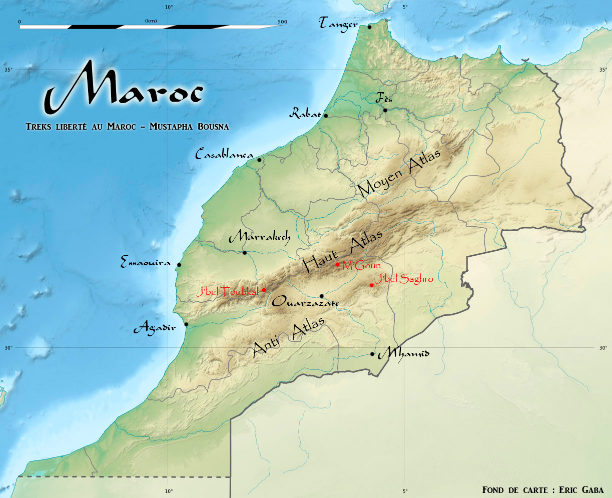
Thanks again cheers from France
Clement
- Merci pour l'information. Sting (talk) 13:30, 21 May 2013 (UTC)
Images in Category:SVG locator maps of provinces in Algeria (orange location map scheme) have no license
editSting, I just noticed that images in Category:SVG locator maps of provinces in Algeria (orange location map scheme) do not have any license templates. I can help adding it if you tell me what it should be. --Jarekt (talk) 18:01, 26 April 2013 (UTC)
Could you teach me ...
edit... how to create quality (relief) location maps, like your maps of France?
I recently discovered the location maps and greatly admire the work done by this project. However, I also noticed that many more location maps are still needed. Take, for instance, Italy. There's a good quality map for the whole country, created by NNW and yourself, and there also some of such maps for a few regions (Sardinia, Calabria, etc.). Several Italian regions only have poor quality location maps, which obviously don't meet the project's quality standards and aren't really useful as a location map (Emilia-Romagna, Liguria, Umbria etc.). Many regions, including the most populous) don't have any location map at all (Lombardy, Campania, Veneto, etc.).
I would like to learn how to create location maps, so I could contribute to the project and add new maps. However, I have no idea how to start or proceed. Suppose I would like to create a relief location map for Lazio. Where could I get the data from? Which program should I use? How can I create the map?
I hope you could teach me. Thank you in advance!
Amphora Dressel 1B request for similar size Qvevri
editHello, I appreciate your work on the Amphora Dressel 1B! I wonder if you would consider doing similar work for a qvevri of similar volume?
Many thanks for the consideration and
Best regards,
Brent
- Hello and thanks for the support. In order to create a drawing of another type of amphora I will need some reliable sources which I haven't unfortunately. Sting (talk) 20:15, 21 May 2013 (UTC)
Use of acerola image
editAloha from Hawaii. I wanted to let you know your acerola image will be used on a plant information sign at the Urban Garden Center on the island of Oahu. The UGC (http://www.ctahr.hawaii.edu/ougc) provides horticultural information to the gardening public. You can email if you would like to see a copy of the sign.
Mahalo (thank you),
Carolyn
- Hello Carolyn. I'm very glad one of my images is useful for your educational purpose. Greetings. Sting (talk) 20:15, 21 May 2013 (UTC)
"Italy relief location map" - physical features only
editHello from Italy! May I ask you to add to your gallery the relief location map of Italy, without the regional borders (but keeping the borders between Italy and the nearby countries)? Thank you very much and my compliments for your works!
Michela
The course of the river Herault
editHi,
I noticed that the course of the river Herault is incorrect as it flows out to the sea via Agde and the Grau d'Agde. Link to map http://upload.wikimedia.org/wikipedia/commons/d/df/Pyrenees_topographic_map-en.svg
Hi Sting. Could you please remove your uploads from this maintenance category? See this edit as an example of how this can be done. --Leyo 09:52, 15 July 2013 (UTC)
Using Map of Lisieux France
editI am going to use this map on my website. www.martinsisters.org Thank you very much. I will place the credit under the picture.
- Thanks for the info. Sting (talk) 13:02, 13 August 2013 (UTC)
Nouvelle-Calédonie
editHello, could you upload relief map equivalent of File:Nouvelle-Calédonie collectivity location map.svg (just without the non-existent Sandy Island/Île de Sable)? You have created very nice centered map several years ago. Szczureq (talk) 11:54, 3 August 2013 (UTC)
 I saw you already did it yourself. Sting (talk) 13:01, 13 August 2013 (UTC)
Carte de Saint-Martin - Utilisation pour carte touristique.
editBonjour,
J'aimerais, dans le cadre d'une association, utiliser la carte pour éditer une carte papier destinée à Saint Martin, pour des activités nautiques, en mentionnant tous vos crédits.
Il y a-t-il des restrictions et conditions autres que de mentionner vos crédits ? Le site d'association (METIMER) : www.metimer.fr Cordialement Jean et Laurence Vallette
--Jlvconcept (d) 3 août 2013 à 16:09 (CEST)
- Répondu. Sting (talk) 12:59, 13 August 2013 (UTC)
Hard drive photo
editEric,
I am the author of the forthcoming textbook "QLab 3 Show Control: Projects for Live Performances and Installations"and I would like to use your photo of the hard drive in the text. Thanks for your consideration.
- Answered. Sting (talk) 13:16, 13 August 2013 (UTC)
Great Minds,
editEurope has generated great Minds in all areas of life. Today some minds explains it very well.
I kinda need to use your image
editI need to use it for my report and I would like to know where did you get the evidence for the Okhotsk plate because all I found was the report from Berkley from 2006. Also thanks for letting people use your work.
- Hello. Glad to know that File:Tectonic_plates_boundaries_detailed-en.svg can be helpful to you. As indicated in the file description, all the references, that means also the one about the Okhotst plate, are taken from the map made by Prof. Peter Bird, Department of Earth and Space Sciences, University of California, Los Angeles. I hope this helps. Sting (talk) 21:56, 19 September 2013 (UTC)
localisation de deux lieux sur : File:France map Lambert-93 topographic-ancient Roman roads.svg
editBonjour, je me permets de te contacter suite à cette contribution que j'ai rétablie sur l'article en français Voies romaines en Gaule : « Attention, la carte a inversé les positions de CAVILLONUM actuellement Châlon/Saône et Andemantunum (Langres)». Après quelques recherches, il semble qu'il y ait inversion des lieux, Langres-Andemantunnum est au nord, et Chalon-sur-Saône-Cavillonum au sud. Sauf erreur de ma part, merci pour ton attention. --Franz53sda (talk) 23:40, 19 September 2013 (UTC)
Use of map
editHey Eric.
I'm interested in using your map on a TV show.
Can you email me at Marcial@twelve02.tv
USED YOUR PIC, THANKS
editHello,
Es requested, I'm sending the link where I used your pic.
Thanks.
Mauro
- Thank you for the notification. Sting (talk) 15:26, 5 November 2013 (UTC)
Info request
editHola Erica Gaba, mi nombre es Emmanuel Vázquez y trabajo para la organización de educación y conservación ambiental Madre Tierra Atabey. (www.ATABEY.info). Le escribo porque estamos muy interesados en utilizar y reproducir la imagen "Map in English of the ecosystems of Puerto Rico" en una herramienta educativa que estamos diseñando. Deseamos conocer si es usted la autora original del mapa o si lo adquirió a través de otra fuente. Puede comunicarse conmigo. Espero leer pronto una respuesta, muchas gracias.
Hi Erica Gaba, my name is Emmanuel Vazquez. I work for Madre Tierra Atabey an education and environmental conservation NGO located in Puerto Rico. (www.ATABEY.info) I am writing because we are interested in use and reproduce the image "Map in English of the ecosystems of Puerto Rico" in an educational tool that we are designing. We want to know if you are the original author of the map or if you find it through another source. You may contact me . I hope to read soon an answer, thank you very much for your time.
- Answered. Sting (talk) 15:24, 5 November 2013 (UTC)
Images de pièces de monnaies de la cgb
editBonjour Sting,
Je viens de m'apercevoir que vous avez enlevé d'Internet mes illustrations de pièces arguant que je n'avais pas les autorisations nécessaires à leur diffusion. Cependant, travaillant au sein de la société cgb, j'ai bien évidemment recu l'accord de l'entreprise pour le partage de sa base de données photographiques.
Afin de clarifier tout malentendu dois-je donc m'adresser directement à wikimedia qui référence les clichés postés ?
Merci de votre aide Philippedorleans (talk)
Use of Topographic map in English of the Isle of Man
editAs permitted under Section 200 of the Commonwealth of Australia Copyright Act 1968, the SACE Board of SA included the following material in its 2013 Year 12 external examiniation paper for Geography:
Ref: 13xGPY_BmC
Citation Map of Isle of Man adapted from Wikipedia File: Isle of Man topographic map-en.svg (c) Eric Gaba - Wikimedia Commons user: Sting (Source: http://en.wikipedia.org/wiki/File:Isle_of_Man_topographic_map-en.svg)
With the examination now over I am writing to yor to advise the use of this material. As per the Creative Commons Attribution-ShareAlike 3.0 Unported Licence, the examination paper will also be made available to the public, both as surplus copies as well as PDF documents for download from the SACE Board website. Occasionally, extracts from the past examination papers are used in support materials for schools, and your material may appear in those materials. These are made available on the website or in professional development sessions as handouts or onscreen.
Pulication Details Audience: Students preparing for the SACE Board examination and teachers of the subject Expected Price: Leftover copies (no more will be printed) $1.60 www.saceboard.sa.edu.au (open access) No charge Duration: Examination and support materials to January 2016
If you have any queries or would like documents showing how we have used your material, please do not hesitate to contact me via email at copyright <at> saceboard <dot> sa <dot> gov <dot> au.
This message is for your information only and is not to be published.
Kind Regards, Kiara Macartney-Clark Knowledge Management Officer SACE Board of South Australia 60 Greenhill Road, Wayville SA 5034
- Thank you for the information. I'm happy to see taht one of my maps can be helpful for an educational purpose like in your case. Sting (talk) 22:23, 18 November 2013 (UTC)
Rapa Nui Map
editSting,
I will be experimenting with using your map on the cover of a self-published book. I am not certain I will, not yet, but I love this map! I thought I should let you know first. I will attribute you in the credits if I do.
Mitbah
- Thank you for the information! Sting (talk) 22:24, 18 November 2013 (UTC)
map of biafra
editHi, Sting,
Wanted to let you know that I'm using your map of Biafra for a class project.
Thanks for a great image!!!
D. T. S.
- Thank you and good luck for your work! Sting (talk) 00:37, 21 November 2013 (UTC)
Usage of three maps by Eric Gaba
editDear Eric
I would like to use a relief map of Italy, Macedonia and France for an iBook that I have written. The iBook is to be used on the iPad and it is an English as a Second Language reader. I am using the maps in a comprehension activity about a famous person, namely Mother Teresa.
Just checking this will be okay with you. I intend to attribute your relief maps with the following text:
Relief maps of France (July 2008), Italy (May 2009) and Macedonia (July 2010) courtesy of Mr. Eric Gaba. http://commons.wikimedia.org/wiki/File:France_relief_location_map.jpg https://commons.wikimedia.org/wiki/File:Italy_relief_location_map.jpg http://commons.wikimedia.org/wiki/File:Macedonia_relief_location_map.jpg
Kind regards
Glen Persello
- Hello Glen. I answered on your discussion page on WP-fr. Sting (talk) 10:46, 3 December 2013 (UTC)
Carte de l'Afrique colonialle
editBonjour, Sting. Je voudrais vous informer de deux petites erreurs dans votre carte (pourtant très bonne, ;)). Les îles équato-guinéens d'Annobón et de Bioko (en face des côtes du Gabon et du Cameroun) étaient espagnoles, pas portugaises, à l'époque de la carte (elles semblent être portugaises). Merci pour votre travail !--Espanish AlB (talk) 20:18, 5 December 2013 (UTC)
Carte du Péloponnèse au MA
editBonjour, Excellent travail ! Je souhaite utiliser cette carte pour la monographie sur la famille byzantine Notaras, originaire de Monemvassia, intitulée "ENTRE LA CROIX ET LE CROISSANT" en cours de publication chez l'Harmattan ; i y aura une liste avec la source des illustrations. Cordialement
Paltin Nottara Paris
- Merci pour l'information. Heureux que cette carte puisse vous être utile. Sting (talk) 01:23, 18 December 2013 (UTC)
Île de Sable
editBonjour Sting !
Eh oui, je traîne toujours sur Wikipédia et Commons, même si je suis moins présent en ce moment.
On nous signale que sur la page de discussion de l'AG que l'île de Sable de ta carte New Caledonia and Vanuatu bathymetric and topographic map-fr.svg n'existe pas, c'est une île fantôme. Peux-tu l'enlever ? Si tu n'a pas de temps à y consacrer, je peux le faire.
Amitiés, Sémhur (talk) 18:59, 16 December 2013 (UTC)