Category:1560s maps of Spain
Countries of Europe: Albania · Belgium · Bosnia and Herzegovina · Croatia · Cyprus‡ · Denmark · France‡ · Germany · Greece · Hungary · Italy · Latvia · Lithuania · Netherlands‡ · Norway · Poland · Portugal‡ · Romania · Russia‡ · Serbia · Slovenia · Spain‡ · Sweden · Turkey‡ · Ukraine
‡: partly located in Europe
‡: partly located in Europe
Media in category "1560s maps of Spain"
The following 14 files are in this category, out of 14 total.
-
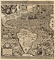 1562 Americæ Gutiérrez.JPG 10,490 × 11,500; 91.89 MB
-
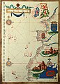 Sebastião Lopes 1575.jpg 2,232 × 3,100; 4.32 MB
-

-
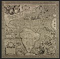 Gutiérrez, the Americas, 1562.jpg 5,246 × 5,148; 16.62 MB
-

-

-

-
 Hispaniae descriptio - Dominicus Zenoi Venetus Restituit - btv1b550048450.jpg 6,962 × 5,559; 6.15 MB
-
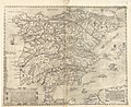
 Hispaniae Descriptio de Domenico Zenoi (1560).jpg 15,678 × 12,175; 28.6 MB
-
 Lázaro Luis 1563.jpg 2,519 × 3,636; 7.12 MB
-
 Mapa de Paulo di Forlani (1560).jpg 5,668 × 4,652; 5.52 MB
-
 Mercator 1569 world map detail Spain.jpg 428 × 427; 89 KB
-
 Península Ibérica no portolano de Giacomo Maggiolo (1563).jpg 2,544 × 1,935; 2.88 MB
-
 UBBasel Map 1567-1567 Kartenslg AA 15.tif 12,012 × 9,844, 2 pages; 338.33 MB


.jpg)

.jpg)

.jpg)