Category:1807 maps of Africa
Temperate regions: North America · South America · Africa · Europe · Asia · – Polar regions: – Other regions:
| ← 1800 1801 1802 1803 1804 1805 1806 1807 1808 1809 → |
Media in category "1807 maps of Africa"
The following 4 files are in this category, out of 4 total.
-
 Atlas elementaire portatif 1807 (139437999).jpg 13,650 × 10,531; 168.15 MB
-
 A map of Lower Egypt... - by Major Bryce ; Drawn by A. Arrowsmith - btv1b530669569.jpg 19,909 × 15,942; 29.21 MB
-
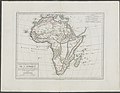
 Africa - DPLA - 82f090ec9d20e29924bc22728d775035.jpg 1,000 × 883; 274 KB
-
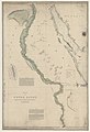 Map of Upper Egypt... - by A. Arrowsmith - btv1b53066955v.jpg 8,294 × 12,178; 10.61 MB
.jpg)


