Category:1824 U.S. presidential election maps
Media in category "1824 U.S. presidential election maps"
The following 20 files are in this category, out of 20 total.
-
 1825ContingentResults.png 800 × 822; 174 KB
-
 Alabama Presidential Election Results 1824.svg 800 × 1,254; 522 KB
-
 Connecticut Presidential Election Results 1824.svg 810 × 595; 30 KB
-
 Election in House1824-Large.PNG 895 × 635; 61 KB
-
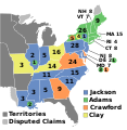
 ElectoralCollege1824-Large.png 868 × 635; 115 KB
-
 ElectoralCollege1824.svg 577 × 593; 190 KB
-
 House Election of 1825-v2.svg 577 × 593; 170 KB
-
 House Election of 1825.svg 1,020 × 593; 43 KB
-
 Illinois Presidential Election Results 1824.png 800 × 1,442; 71 KB
-
 Maine Presidential Election Results 1824.svg 800 × 1,219; 3.21 MB
-
 Maryland Presidential Election Results 1824.png 1,280 × 686; 87 KB
-
 Massachusetts Presidential Election Results 1824.svg 810 × 502; 27 KB
-
 Mississippi Presidential Election Results 1824.svg 800 × 1,374; 358 KB
-
 Missouri Presidential Election Results 1824.svg 800 × 828; 496 KB
-
 New Jersey Presidential Election Results 1824.svg 800 × 1,517; 560 KB
-
 Ohio Presidential Election Results 1824.svg 810 × 810; 35 KB
-
 Pennsylvania Presidential Election Results 1824.png 1,024 × 597; 129 KB
-
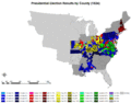 PresidentialCounty1824.gif 2,800 × 2,200; 169 KB
-
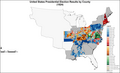 PresidentialCounty1824Colorbrewer.png 2,800 × 1,700; 169 KB
-
 Rhode Island Presidential Election Results 1824.svg 810 × 810; 13 KB


