Category:1828 U.S. presidential election maps
Media in category "1828 U.S. presidential election maps"
The following 14 files are in this category, out of 14 total.
-
 PresidentialCounty1828Colorbrewer.gif 2,800 × 1,700; 114 KB
-
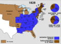 1828 Electoral Map.png 868 × 635; 123 KB
-
 Alabama Presidential Election Results 1828.svg 800 × 1,254; 560 KB
-
 Connecticut Presidential Election Results 1828.svg 810 × 595; 30 KB
-
 ElectoralCollege1828-Large.png 868 × 635; 78 KB
-
 ElectoralCollege1828.svg 577 × 593; 172 KB
-
 Georgia Presidential Election Results 1828.svg 800 × 944; 1.62 MB
-
 Massachusetts Presidential Election Results 1828.svg 810 × 502; 27 KB
-
 New Jersey Presidential Election Results 1828.svg 800 × 1,517; 547 KB
-
 New York Presidential Election Results 1828.svg 800 × 610; 1,008 KB
-
 PresidentialCounty1828.gif 2,800 × 2,200; 157 KB
-
 Rhode Island Presidential Election Results 1828.svg 810 × 810; 13 KB
-
 Vermont Presidential Election Results 1828.svg 370 × 585; 9 KB
-
 Virginia Presidential Election Results 1828.svg 514 × 361; 341 KB


