Category:1830s maps of Belgium
Countries of Europe: Albania · Armenia‡ · Azerbaijan‡ · Belgium · Bulgaria · Cyprus‡ · Czech Republic · Denmark · Estonia · Finland · France‡ · Georgia‡ · Germany · Greece · Hungary · Republic of Ireland · Italy · Latvia · Lithuania · Netherlands‡ · Norway · Poland · Portugal‡ · Romania · Russia‡ · Slovenia · Spain‡ · Sweden · Switzerland · Turkey‡ · Ukraine · United Kingdom
Limited recognition: Abkhazia‡
‡: partly located in Europe
Limited recognition: Abkhazia‡
‡: partly located in Europe
Media in category "1830s maps of Belgium"
The following 10 files are in this category, out of 10 total.
-
 1831 Félix Delamarche map of the United Kingdom of the Netherlands.jpg 2,168 × 3,000; 1.51 MB
-
 10 of 'History of the King's German Legion. (With plates.)' (11008530296).jpg 3,278 × 3,060; 2.15 MB
-
 1832 map of Antwerp.jpg 9,592 × 7,598; 14.36 MB
-
 Plan Der Belagerung Der Citadelle von Antwerpen (cropped).jpg 4,210 × 3,209; 3.31 MB
-
 Plan Der Belagerung Der Citadelle von Antwerpen.jpg 7,865 × 6,024; 8.98 MB
-
 Niederlande, Belgien, Luxemburg.jpg 4,555 × 5,679; 8.82 MB
-

-
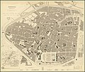 1837 map of Brussels.jpg 9,352 × 8,048; 20.38 MB
-
 Bruxelles - Umgebung mit Verkehrswegen.jpg 7,624 × 6,226; 17.61 MB
-
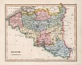 MapBelg1832-1724.jpg 5,816 × 4,600; 6.72 MB

%27_(11008530296).jpg)

.jpg)


