Category:1855 maps
| ← · 1850 · 1851 · 1852 · 1853 · 1854 · 1855 · 1856 · 1857 · 1858 · 1859 · → |
Deutsch: Karten mit Bezug zum Jahr 1855
English: Maps related to the year 1855
Español: Mapas relativos al año 1855
Français : Cartes concernant l’an 1855
Русский: Карты 1855 года
Subcategories
This category has the following 10 subcategories, out of 10 total.
Media in category "1855 maps"
The following 200 files are in this category, out of 203 total.
(previous page) (next page)-
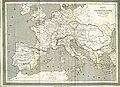 "Imperio de Carlomagno". (4114984452).jpg 7,019 × 5,100; 13.4 MB
-

-

-
 (Land ownership map of the town of Fryeburg, Maine). LOC 78695998.jpg 10,184 × 13,234; 17.74 MB
-
 (Map of the Arctic and adjacent regions). LOC 85693100.tif 9,131 × 9,629; 251.55 MB
-

-

-
 Mertendorf 1855 rechts.JPG 1,166 × 817; 200 KB
-
 HEINZELMANN(1855) 16.1013 Kartenblatt Nordwestpassage.jpg 2,137 × 1,525; 1.74 MB
-
 TOBIN(1855) p189 PALESTINE.jpg 2,635 × 3,621; 3.79 MB
-
-

-
 1855 Colton Map of Balochistan.jpg 1,068 × 743; 275 KB
-

-
 1855 Colton Map of Cuba, Jamaica and Porto Rico - Geographicus - Cuba-colton-1855.jpg 4,000 × 3,328; 4.1 MB
-
 1855 Colton Map of Denmark - Geographicus - Denmark-colton-1855.jpg 2,851 × 3,500; 3.12 MB
-
 1855 Colton Map of France - Geographicus - France-colton-1855.jpg 2,913 × 3,500; 3.6 MB
-
 1855 Colton Map of Georgia - Geographicus - Georgia-colton-1855.jpg 3,318 × 4,000; 3.99 MB
-
 1855 Colton Map of Greece - Geographicus - Greece-colton-1855.jpg 3,500 × 2,841; 3.19 MB
-

-
 1855 Colton Map of Illinois - Geographicus - IL-colton-1855.jpg 3,350 × 4,000; 4.34 MB
-
 1855 Colton Map of India or Hindostan - Geographicus - India-cbl-1855.jpg 2,495 × 3,000; 2.23 MB
-

-

-

-
 1855 Colton Map of Kentucky and Tennessee - Geographicus - KentuckyTennessee-colton-1855.jpg 4,000 × 3,210; 4.22 MB
-
 1855 Colton Map of Maine - Geographicus - Maine-colton-1855.jpg 3,304 × 4,000; 4 MB
-
 1855 Colton Map of Mexico - Geographicus - Mexico-colton-1855.jpg 4,000 × 3,300; 4.01 MB
-
 1855 Colton Map of Michigan - Geographicus - Michigan-colton-1855.jpg 3,274 × 4,000; 4.09 MB
-
 1855 Colton Map of Minnesota - Geographicus - Minnesota-colton-1855.jpg 4,000 × 3,371; 3.61 MB
-
 1855 Colton Map of Mississippi - Geographicus - Mississippi-colton-1855.jpg 3,211 × 4,000; 3.96 MB
-
 1855 Colton Map of Missouri - Geographicus - Missouri-colton-1855.jpg 4,000 × 3,310; 3.79 MB
-

-
 1855 Colton Map of North Carolina - Geographicus - NorthCarolina-colton-1855.jpg 4,000 × 3,214; 4.05 MB
-
 1855 Colton Map of Northeastern Africa - Geographicus - AfricaNorthEast-colton-1855.jpg 2,875 × 3,500; 2.89 MB
-
 1855 Colton Map of Ohio - Geographicus - Ohio-colton-1855.jpg 4,000 × 3,268; 4.23 MB
-

-

-
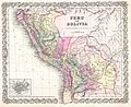 1855 Colton Map of Peru and Bolivia - Geographicus - PeruBolivia-colton-1855.jpg 4,000 × 3,255; 3.66 MB
-

-
 1855 Colton Map of Scotland - Geographicus - Scotland-colton-1855.jpg 2,904 × 3,500; 3.53 MB
-
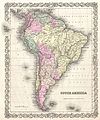 1855 Colton Map of South America - Geographicus - SouthAmerica-colton-1855.jpg 3,335 × 4,000; 4.04 MB
-
 1855 Colton Map of South Carolina - Geographicus - SouthCarolina-colton-1855.jpg 4,000 × 3,310; 3.92 MB
-
 1855 Colton Map of Switzerland - Geographicus - Switzerland-colton-1855.jpg 3,500 × 2,878; 3.59 MB
-
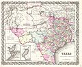 1855 Colton Map of Texas - Geographicus - Texas-colton-1855.jpg 4,000 × 3,270; 3.6 MB
-
 1855 Colton Map of the Arctic or North Pole - Geographicus - NorthernRegions-colton-1855.jpg 3,314 × 4,000; 4.26 MB
-
 1855 Colton Map of the West Indies - Geographicus - WestIndies-colton-1855.jpg 4,000 × 3,261; 4.17 MB
-
 1855 Colton Map of the Western Hemisphere - Geographicus - HemiWest-c-55.jpg 3,000 × 3,201; 2.4 MB
-
 1855 Colton Map of Virginia - Geographicus - Virginia-colton-1855.jpg 4,000 × 3,289; 4.08 MB
-

-

-
 1855 Colton Map or City Plan of Paris, France - Geographicus - Paris-c-55.jpg 3,000 × 2,451; 2.84 MB
-

-
 1855 Colton Map or Plan of London, England - Geographicus - London-c-55.jpg 3,000 × 2,433; 2.64 MB
-
 1855 Colton Plan or Map of Baltimore, Maryland - Geographicus - Baltimore-colton-1855.jpg 4,000 × 3,295; 3.92 MB
-

-
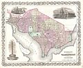 1855 Colton Plan or Map of Washington D.C. - Geographicus - WashingtonDC2-colton-1855.jpg 4,000 × 3,284; 3.51 MB
-
 1855 Colton World Mountains and Rivers Map or Chart - Geographicus - MtsRvrs-colton-1855.jpg 5,000 × 3,524; 5.85 MB
-
 1855 Damascus map byPorter.png 1,210 × 732; 827 KB
-

-
 1855 map of Charleston, South Carolina.jpeg 2,198 × 3,518; 1.06 MB
-
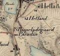 1855 Paradis.jpg 467 × 440; 96 KB
-

-
-
 1855 Spruner Map of the Americas up to 1776 - Geographicus - AmericaBis1776-spruner-1855.jpg 3,500 × 4,523; 3.08 MB
-

-

-

-

-

-
 Abhandlungen der Königlichen Akademie der Wissenschaften in Berlin (1855) (16559092217).jpg 4,550 × 2,449; 1.93 MB
-
 Administrativ-Karte des Herzogthum's Krain 1855.jpg 10,524 × 8,243; 13.49 MB
-
 Admiralty Chart No 260 North Polar Sea, Published 1855 2.jpg 14,940 × 18,750; 66.52 MB
-

-
 Basin of the North Atlantic Ocean.jpg 2,532 × 1,972; 2.28 MB
-
 Bennington Heights, VT August 16, 1777.jpg 2,081 × 2,154; 1.74 MB
-
 Bezetsk 1855.jpg 3,582 × 5,661; 8.11 MB
-
-
 Volume 1 Index Map.) NYPL1268453.tiff 6,299 × 4,912; 88.54 MB
-
 Volume 2 Index Map.) NYPL1268454.tiff 6,299 × 4,880; 87.97 MB
-
 Canada East 1855.jpg 1,502 × 982; 349 KB
-
 Canton de Genève LOC 2012593355.jpg 4,147 × 2,903; 1.97 MB
-
 Canton de Genève LOC 2012593355.tif 4,147 × 2,903; 34.44 MB
-
 Caozhou Fu Shan Xian nan di dong hao tu. LOC 73693312.jpg 7,856 × 9,088; 6.79 MB
-
 Caozhou Fu Shan Xian nan di dong hao tu. LOC 73693312.tif 7,864 × 9,088; 204.49 MB
-
 Carl Poppey, Syrien und die angrænzenden Länder zur Zeit der Kreuzzüge (FL33144810 3881640).jpg 11,141 × 8,905; 150.33 MB
-
 Carpathians to Dnieper.jpg 1,880 × 1,393; 1.13 MB
-
 Carte physique, administrative et routière de la Suisse LOC 2012593357.jpg 10,744 × 8,283; 20.62 MB
-
 Carte physique, administrative et routière de la Suisse LOC 2012593357.tif 10,744 × 8,283; 254.61 MB
-
 Chart of the North Polar Sea LOC 2018587008.jpg 9,505 × 7,527; 12.76 MB
-
 Chart of the North Polar Sea LOC 2018587008.tif 9,505 × 7,527; 204.69 MB
-
 Cleveland and Toledo Rail-Road 1856. LOC 98688636.jpg 1,904 × 1,720; 539 KB
-
 Cleveland and Toledo Rail-Road 1856. LOC 98688636.tif 1,904 × 1,720; 9.37 MB
-

-

-
 Colton's railroad and township map of Arkansas (11842833283).jpg 2,000 × 1,652; 3.65 MB
-

-

-

-

-

-
 Der Kaukasiche Isthmus - Entworfen u. gezeichnet von J. Grässl..jpg 1,276 × 992; 726 KB
-
 Die Völker und Reiche der Slaven zwichen Elbe und Don bis 1125 - Chrobacia.jpg 1,296 × 1,320; 703 KB
-
 Edward Weller, Map of Palestine and portions of Syria and Arabia (FL6880964 2668139).jpg 3,624 × 7,224; 38.91 MB
-
 Ermete Pierotti, Plan de Iérusalem (FL6880177 2369728).jpg 2,850 × 2,161; 2.12 MB
-
 Eure on 1855 Spruneri Map of Gaul in Ancient Times.jpg 607 × 448; 296 KB
-

-

-
 Flurkarte Westendorf 1855.jpg 3,840 × 2,448; 1.76 MB
-
 From Great Salt Lake to the Humboldt Mountains. LOC 98688430.jpg 5,521 × 6,283; 4.41 MB
-
 From Great Salt Lake to the Humboldt Mountains. LOC 98688430.tif 5,521 × 6,283; 99.24 MB
-
 From the Humboldt Mountains to the Mud Lakes. LOC 98688431.jpg 5,567 × 6,319; 5.13 MB
-
 From the Humboldt Mountains to the Mud Lakes. LOC 98688431.tif 5,567 × 6,319; 100.64 MB
-
 From the valley of Green River to the Great Salt Lake. LOC 98688429.jpg 5,490 × 6,308; 5.31 MB
-
 From the valley of Green River to the Great Salt Lake. LOC 98688429.tif 5,490 × 6,308; 99.08 MB
-

-

-

-

-
 International rail road guide of the Great Central Route. LOC 98688671.jpg 8,107 × 4,086; 6.23 MB
-
 International rail road guide of the Great Central Route. LOC 98688671.tif 8,107 × 4,086; 94.77 MB
-
 Interoceanic river aqueduct connecting the Pacific and Atlantic Oceans - (Colombia) LOC 2009582841.tif 27,148 × 11,370; 883.12 MB
-
 J. H. Colton, Colton's Palestine (FL6881393 2643520).jpg 4,464 × 5,312; 34.25 MB
-
 Japan - Nipon, Kiusiu and Sikok, and a part of the coast of Korea LOC 2015588080.tif 11,773 × 9,547; 321.57 MB
-
 Kalyazin 1855.jpg 3,657 × 5,640; 8.67 MB
-
 Kansas-Nebraska Act.jpg 5,194 × 8,081; 41.2 MB
-
 Karl Georg von Raumer, Palaestina (FL33142070 3881493).jpg 10,641 × 8,731; 119.22 MB
-
 Karte des Kronlandes Steiermark 1855.jpg 15,276 × 16,641; 33.22 MB
-
 Kashin 1855.jpg 3,669 × 5,658; 9.87 MB
-
 Korcheva 1855.jpg 3,609 × 5,611; 8.84 MB
-
 Kreiseinteilung Graz Marburg 1855.jpg 1,245 × 780; 512 KB
-
 Linguistic map of Eastern Europe, Max Müller, 1854.jpg 3,913 × 2,954; 3.4 MB
-
 Lyman Coleman, Ancient Jerusalem (FL45582261 3918260).jpg 3,113 × 2,049; 3.03 MB
-
 Map of Montague Village (7537847584).jpg 1,507 × 2,000; 2.68 MB
-

-

-
 Map of the Arctic and adjacent regions. LOC 85693100.jpg 9,131 × 9,629; 13.01 MB
-
 Map of the Chicago, St. Paul & Fond du Lac Railroad. LOC 98688631.jpg 5,244 × 5,013; 3.79 MB
-
 Map of the Chicago, St. Paul & Fond du Lac Railroad. LOC 98688631.tif 5,244 × 5,013; 75.21 MB
-
 Map of the city of Belfast, Waldo Co., Maine LOC 2007626398.jpg 13,275 × 15,000; 23.24 MB
-
 Map of the city of Concord New Hampshire (4579419484).jpg 7,821 × 8,746; 19.61 MB
-
 Map of the island of Cuba - compiled from the most reliable Spanish authorities. LOC 2010587903.jpg 14,657 × 10,571; 18.86 MB
-
 Map of the island of Cuba - compiled from the most reliable Spanish authorities. LOC 2010587903.tif 14,657 × 10,571; 443.28 MB
-
 Map of the La Crosse and Milwaukee Rail Road and connections. LOC 98688691.jpg 12,514 × 7,881; 14.52 MB
-
 Map of the La Crosse and Milwaukee Rail Road and connections. LOC 98688691.tif 12,514 × 7,881; 282.16 MB
-

-

-
 Map of the Manassas Gap Railroad and its extensions; September, 1855. LOC 98688704.jpg 11,265 × 7,303; 13.1 MB
-
 Map of the Manassas Gap Railroad and its extensions; September, 1855. LOC 98688704.tif 11,265 × 7,303; 235.37 MB
-
 Map of the town of Canaan N.H. Grafton Co. (6093625017).jpg 2,000 × 1,324; 2.03 MB
-
 Map of Tibet in 1855 from Vorder-Indien oder das Indo-Britische Reich (cropped).jpg 3,475 × 1,630; 2.64 MB
-
 Map of Windsor County, Vermont LOC 2012586225.jpg 13,547 × 16,471; 36.33 MB
-

-

-
 Mappa Caltanisetta 1855.png 326 × 468; 363 KB
-
 Mississippi. LOC 2012586806.jpg 4,371 × 5,283; 4.36 MB
-
 Mississippi. LOC 2012586806.tif 4,371 × 5,283; 66.07 MB
-
 Mitchell Map 1850 country of Balochistan.jpg 1,235 × 737; 442 KB
-
 MN WI 1855.jpg 1,800 × 1,527; 1.31 MB
-
 Nebraska and Kansas LOC 2006458669.tif 6,694 × 9,014; 172.63 MB
-
 Nebraska and Kanzas LOC 2017586283.jpg 5,311 × 4,497; 3.57 MB
-
 Nebraska and Kanzas LOC 2017586283.tif 5,311 × 4,497; 68.33 MB
-

-

-
-

-
 Palaestina za casu Krista Pana (FL36567038 3914731).jpg 12,493 × 12,146; 212.41 MB
-
 Palestine (FL37124248 3901459).jpg 2,775 × 4,079; 5.83 MB
-
 Patagonia, 1855.jpg 1,054 × 1,297; 513 KB
-
 Persia et India.jpg 755 × 600; 116 KB
-
 Pilot chart of the north Indian Ocean LOC 2009575931.jpg 10,802 × 7,049; 10.15 MB
-
 Pilot chart of the north Indian Ocean LOC 2009575931.tif 10,802 × 7,049; 217.85 MB
-
 Plan of Groton Cemetery (3369693653).jpg 1,575 × 2,000; 3.09 MB
-

-
 Plan of the city of Jerusalem in the time of Christ (FL45582646 3924372).jpg 1,596 × 1,304; 1.09 MB
-

-
 Plan von Berlin mit dem Weichbilde und der Umgegend bis Charlottenburg 1855.jpg 7,379 × 5,577; 22.59 MB
-
 Planol via ferria gran 1855.jpg 2,550 × 1,755; 712 KB
-

-

-

-

-
 Sectional map of southern Minnesota LOC 2012593518.jpg 9,490 × 6,007; 8.57 MB
-
 Sectional map of southern Minnesota LOC 2012593518.tif 9,490 × 6,007; 163.1 MB
-

-

-
-

-

-
 Stone (Tittensor & Darlaston) enclosure map - 1855 - 47937-0.jpg 4,716 × 6,000; 2.09 MB
-
 Sumner road ordinance.jpg 768 × 597; 19 KB
-

-
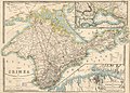 The Crimea LOC 2015591080.jpg 8,102 × 5,814; 8.31 MB
-
 The physical geography of the sea BHL47369935.jpg 4,190 × 3,292; 1.96 MB
-

-

-
 View of the city of Whitewater, Wis. Walworth-County 1855. LOC 75696730.jpg 10,016 × 6,208; 15.24 MB
-
 View of the city of Whitewater, Wis. Walworth-County 1855. LOC 75696730.tif 10,016 × 6,208; 177.9 MB
-
 Vorder-Indien oder das Indo-Britische Reich.jpg 5,683 × 4,568; 8.96 MB
-

.jpg)
._LOC_78695998.jpg)
_LOC_87694238.jpg)

_16.1013_Kartenblatt_Nordwestpassage.jpg)
_p189_PALESTINE.jpg)


_-_Geographicus_-_NebraskaKansas-colton-1855_(edited).jpg)
_-_Geographicus_-_NebraskaKansas-colton-1855.jpg)


_-_Geographicus_-_NewYorkCity-colton-1855.jpg)


_-_Geographicus_-_PersiaArabia-c-55.jpg)


_-_Geographicus_-_AsienFunften-spruneri-1855.jpg)


_-_Geographicus_-_AfricaNorth-spruneri-1855.jpg)

_(16559092217).jpg)


.jpg)


.jpg)


.jpg)
.jpg)
.jpg)

_(20663280850).jpg)


.jpg)
.jpg)


.jpg)


.jpg)


.jpg)
.jpg)


.jpg)


.jpg)
.jpg)

.jpg)


_-_Geographicus_-_NewYork33MilesAround-colton-1855.jpg)

.jpg)
.jpg)


.jpg)
.jpg)
.jpg)
.jpg)


,_also_that_of_the_41_parallel_of_latitude_explored_by_Lieutenant_E._G._P._Beckwith_3d._LOC_98688428.jpg)
_enclosure_map_-_1855_-_47937-0.jpg)


.jpg)
_LOC_80692838.jpg)