Category:1869 maps of Iowa
States of the United States: California · Illinois · Iowa · Massachusetts · Missouri · New York · Oregon · Texas
| 1860 1861 1865 1868 1869 |
Media in category "1869 maps of Iowa"
The following 4 files are in this category, out of 4 total.
-
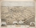
 Bird's eye view of Guttenberg, Clayton County, Iowa 1869. LOC 73693397.jpg 7,040 × 5,440; 6.04 MB
-
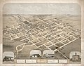 Birds eye view of Pella, Marion County, Iowa, 1869 LOC 2013586120.jpg 9,518 × 7,464; 14.14 MB
-
 Birds eye view of Pella, Marion County, Iowa, 1869 LOC 2013586120.tif 9,518 × 7,464; 203.25 MB
-
 Map of Delaware County, Iowa LOC 2012587574.jpg 11,057 × 12,716; 22.06 MB


