Category:1869 maps of New York (state)
States of the United States: California · Illinois · Iowa · Massachusetts · Missouri · New York · Oregon · Texas
Subcategories
This category has only the following subcategory.
Media in category "1869 maps of New York (state)"
The following 18 files are in this category, out of 18 total.
-

-
-

-
 64 Central Park Lots, New York City. - map by Muller, A. H. -1869 NYPL2015216.tiff 5,973 × 4,872; 83.29 MB
-
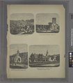
 Annual report of the Board of Commissioners of the Central Park (1858) (18246085158).jpg 5,312 × 2,014; 1.77 MB
-
 Atlas of Chemung Co. New York NYPL1583015.tiff 5,202 × 6,332; 94.24 MB
-
 Atlas of Clinton Co., New York (Title page) NYPL1576094.tiff 4,850 × 5,214; 72.35 MB
-
 Atlas of Delaware Co., New York NYPL1582944.tiff 5,266 × 6,018; 90.67 MB
-
 1869 Bishop Map of Brooklyn, New York - Geographicus - Brooklyn-bishop-1869.jpg 4,000 × 3,149; 2.66 MB
-

-
 Chemung County New York - Beers 1869.jpg 4,556 × 5,751; 15.63 MB
-
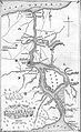 Map of the Niagara Frontier, 1869.jpg 482 × 787; 325 KB
-

-
 Southport (Township); Southport Subscriber's Business Directory. NYPL1583033.tiff 7,012 × 5,038; 101.07 MB
-

-
 St. Marys Church; City of Troy (cont.); Vails Block. NYPL1584724.tiff 7,212 × 4,670; 96.36 MB
-
 St. Peters Collage. ;City of Troy (cont.) NYPL1584723.tiff 7,212 × 4,616; 95.25 MB
-
 Stamford (Village); Stamford (Township); Stamford Business Directory NYPL1582965.tiff 6,018 × 5,258; 90.53 MB


_(18246085158).jpg)