Category:1875 maps of Europe
Temperate regions: North America · South America · Africa · Europe · Asia · Oceania – Polar regions: – Other regions:
English: 1875 maps of Europe
Español: Mapas de Europa en 1875
Suomi: Euroopan kartat vuodelta 1875
Română: Hărți ale Europei din 1875
Subcategories
This category has the following 12 subcategories, out of 12 total.
.
F
- 1875 maps of Finland (empty)
- 1875 maps of France (14 F)
G
M
- Map of Europe by Treaty, 1875 (82 F)
N
R
- 1875 maps of Russia (1 F)
S
- 1875 maps of Spain (5 F)
T
- 1875 maps of Turkey (2 F)
Media in category "1875 maps of Europe"
The following 28 files are in this category, out of 28 total.
-
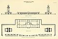
 ELLIOT(1875) p075 - Plate I. South Foreland, general plan of light-houses.jpg 1,904 × 1,398; 1.28 MB
-
 ELLIOT(1875) p079 - Plate II. South Foreland, ground-plan of engine-house.jpg 1,910 × 1,342; 1.15 MB
-
 ELLIOT(1875) p125 - Plate VI. Haishorough, general plan.jpg 1,882 × 1,402; 1.05 MB
-
 ELLIOT(1875) p167 - Plate XVI. Coquet Island, chart of vicinity.jpg 1,448 × 2,310; 1.88 MB
-
 ELLIOT(1875) p189 - Plate XX. Land's End, chart of vicinity.jpg 1,534 × 2,430; 2.17 MB
-
 ELLIOT(1875) p301 - Plate XXXVII. LaHave, elevation and general plan.jpg 2,220 × 1,484; 1.41 MB
-
 Map of Amsterdam (1385-1875).jpg 3,251 × 2,677; 5.13 MB
-
 PATERSON(1875) p010 PLAN OF EDINBURGH.jpg 4,251 × 3,603; 8.67 MB
-
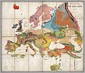 1875 Dumont's geological map of Europe.jpg 4,277 × 3,674; 2.66 MB
-
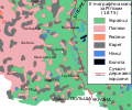
 A part of the ethnographic map by Rittikh, 1875.svg 1,672 × 975; 2.18 MB
-
 Audierne plan d'accès port.jpg 1,505 × 2,042; 1.91 MB
-
 Aufnahmeblatt 4757-1-a 1875 Wien Innenstadt.jpg 9,598 × 7,433; 43.77 MB
-
 Baker Street area Ordnance Survey map 1875.jpg 6,214 × 9,000; 26.14 MB
-

-
 Ethnic composition of Kholmshchyna, Rittikh, 1875-en.svg 1,000 × 835; 217 KB
-
 Ethnic composition of Kholmshchyna, Rittikh, 1875.svg 1,000 × 835; 214 KB
-
 Ethnic composition of Pidliashshia, Rittikh, 1875-en.svg 780 × 1,340; 244 KB
-
 Ethnic composition of Pidliashshia, Rittikh, 1875.svg 780 × 1,340; 243 KB
-
 Europe - par Georges Erhard - btv1b53223975z.jpg 10,684 × 9,970; 22.5 MB
-
 Karte Hochjochhospiz 1875.png 1,128 × 1,236; 2.16 MB
-
 Karte Samoarhütte 1875.png 1,242 × 1,365; 2.49 MB
-
 Lago Fucino 1875.jpg 3,581 × 2,334; 763 KB
-
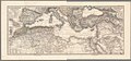 Mediterranean map 1875.jpg 13,961 × 6,485; 25.33 MB
-

-

-
 Northwestern borders of Ukrainians, Rittikh, 1875.svg 4,050 × 1,550; 821 KB
-
 Railway belgium 1875.jpg 1,646 × 1,265; 205 KB
-

_p075_-_Plate_I._South_Foreland,_general_plan_of_light-houses.jpg)
_p079_-_Plate_II._South_Foreland,_ground-plan_of_engine-house.jpg)
_p125_-_Plate_VI._Haishorough,_general_plan.jpg)
_p167_-_Plate_XVI._Coquet_Island,_chart_of_vicinity.jpg)
_p189_-_Plate_XX._Land%27s_End,_chart_of_vicinity.jpg)
_p301_-_Plate_XXXVII._LaHave,_elevation_and_general_plan.jpg)
.jpg)
_p010_PLAN_OF_EDINBURGH.jpg)


_(14596383039).jpg)
_(14596539657).jpg)
