Category:1881 maps of Connecticut
States of the United States: California · Connecticut · Hawaii · Idaho · Illinois · Iowa · Louisiana · Maryland · Massachusetts · Michigan · New Mexico · New York · Pennsylvania · South Dakota · Texas · Utah · Wyoming
| 1881 1883 1884 1885 1886 1887 1888 1889 → |
Media in category "1881 maps of Connecticut"
The following 11 files are in this category, out of 11 total.
-
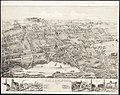
 View of Chester, Connecticut (2675160295).jpg 2,000 × 1,574; 2.83 MB
-
 View of Clinton, Connecticut (2675161721).jpg 8,880 × 7,056; 9.2 MB
-
 View of Clinton, Connecticut 1881. LOC 74693231.jpg 7,968 × 6,288; 9.16 MB
-
 View of Essex, Centerbrook & Ivoryton, Conn. (2675163421).jpg 2,000 × 1,652; 3.14 MB
-
 View of Essex, Centerbrook & Ivoryton, Conn. 1881. LOC 74693147.jpg 8,176 × 6,400; 10.49 MB
-
 View of Guilford, Connecticut (2675164389).jpg 8,744 × 6,865; 23.64 MB
-
 View of Higganum, Connecticut (2675165983).jpg 2,000 × 1,564; 2.62 MB
-
 View of Higganum, Connecticut 1881. LOC 74693145.jpg 6,848 × 6,448; 7.82 MB
-
 View of Madison, Conn. (2675984004).jpg 2,000 × 1,355; 2.17 MB
-
 View of Madison, Conn. 1881. LOC 74693144.jpg 7,568 × 5,216; 6.96 MB
-
 View of Wallingford, Connecticut (2674635588).jpg 2,000 × 1,583; 2.91 MB
.jpg)
.jpg)

.jpg)

.jpg)
.jpg)

.jpg)

.jpg)