Category:1883 maps of Hawaii
States of the United States: California · Connecticut · Florida · Hawaii · Illinois · Indiana · Iowa · Kansas · Louisiana · Maryland · Massachusetts · Michigan · Minnesota · Missouri · Montana · New Hampshire · New Mexico · New York · North Dakota · Ohio · Oregon · Pennsylvania · South Carolina · South Dakota · Texas · Virginia · Washington · Wisconsin · Wyoming
| 1881 1883 1885 1886 → |
Media in category "1883 maps of Hawaii"
The following 2 files are in this category, out of 2 total.
-
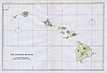 1883 U.S.G.S. Map of the Hawaiian Islands - Geographicus - Hawaii2-USGS-1883.jpg 4,000 × 2,727; 1,013 KB
-
 1883 U.S.G.S. Map of the Island of Hawaii - Geographicus - HawaiiHawaii2-USGS-1883.jpg 2,551 × 2,896; 1.17 MB

