Category:1883 maps of Montana
States of the United States: California · Connecticut · Florida · Hawaii · Illinois · Indiana · Iowa · Kansas · Louisiana · Maryland · Massachusetts · Michigan · Minnesota · Missouri · Montana · New Hampshire · New Mexico · New York · North Dakota · Ohio · Oregon · Pennsylvania · South Carolina · South Dakota · Texas · Virginia · Washington · Wisconsin · Wyoming
| ← 1883 1884 1886 1888 1889 → |
Media in category "1883 maps of Montana"
The following 7 files are in this category, out of 7 total.
-

-

-
 Bird's eye view of Livingston, Mon., Gallatin County 1883. LOC 75694671.jpg 7,056 × 4,784; 6.91 MB
-
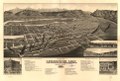 Bird's eye view of Livingston, Mon., Gallatin County 1883. LOC 75694671.tif 7,056 × 4,784; 96.58 MB
-
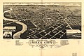 Bird's eye view of Miles City, c.s. of Custer County, Montana 1883. LOC 75694672.jpg 6,976 × 4,640; 4.86 MB
-
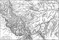 EB9 Montana.jpg 2,555 × 1,738; 842 KB
-
 HelenaMontana1883-Plat.jpg 8,400 × 5,104; 11.83 MB


