Category:1889 maps of Mississippi
States of the United States: California · Connecticut · Florida · Georgia · Illinois · Iowa · Kansas · Kentucky · Louisiana · Maine · Massachusetts · Michigan · Minnesota · Mississippi · Missouri · Montana · New Hampshire · New Jersey · New Mexico · New York · Ohio · Oregon · Pennsylvania · Rhode Island · South Carolina · Tennessee · Texas · Utah · Vermont · Washington · Wisconsin
| 1885 1886 1887 1889 → |
Subcategories
This category has the following 3 subcategories, out of 3 total.
Media in category "1889 maps of Mississippi"
The following 10 files are in this category, out of 10 total.
-
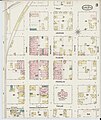
 Sanborn Fire Insurance Map from Corinth, Alcorn County, Mississippi, 1889, Plate 0001.jpg 6,450 × 7,650; 3.61 MB
-
 Sanborn Fire Insurance Map from Corinth, Alcorn County, Mississippi, 1889, Plate 0001.tiff 6,450 × 7,650; 141.17 MB
-
 Sanborn Fire Insurance Map from Corinth, Alcorn County, Mississippi, 1889, Plate 0002.jpg 6,450 × 7,650; 3.56 MB
-
 Sanborn Fire Insurance Map from Corinth, Alcorn County, Mississippi, 1889, Plate 0002.tiff 6,450 × 7,650; 141.17 MB
-
 Sanborn Fire Insurance Map from Corinth, Alcorn County, Mississippi, 1889, Plate 0003.jpg 6,450 × 7,650; 3.61 MB
-
 Sanborn Fire Insurance Map from Corinth, Alcorn County, Mississippi, 1889, Plate 0003.tiff 6,450 × 7,650; 141.17 MB
-
 Sanborn Fire Insurance Map from Corinth, Alcorn County, Mississippi, 1889, Plate 0004.jpg 6,450 × 7,650; 3.19 MB
-
 Sanborn Fire Insurance Map from Corinth, Alcorn County, Mississippi, 1889, Plate 0004.tiff 6,450 × 7,650; 141.17 MB
-

-
 Sanborn Fire Insurance Map from Vaiden, Carroll County, Mississippi. LOC sanborn04535 001.tif 6,450 × 7,650; 141.17 MB


