Category:1890s maps of the Ottoman Empire
Subcategories
This category has the following 15 subcategories, out of 15 total.
- 1897 maps of the Ottoman Empire (empty)
- 1898 maps of the Ottoman Empire (empty)
'
.
- 1890s maps of Bulgaria (4 F)
- 1890s maps of Cyprus (6 F)
- 1890s maps of Jordan (2 F)
- 1890s maps of Lebanon (empty)
- 1890s maps of Syria (4 F)
Media in category "1890s maps of the Ottoman Empire"
The following 9 files are in this category, out of 9 total.
-
 1890 map of Turkey in Europe in Ottoman Turkish.jpg 19,650 × 13,696; 126.24 MB
-
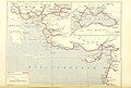 10 of 'Autour de la Méditerranée ... Illustrations par A. Chapon, etc' (11215391434).jpg 3,008 × 2,027; 1.82 MB
-

-
 IAN 0269 Halil Imbrahim 1896 Epirus.jpg 4,804 × 9,591; 33.99 MB
-
 IAN 0172.jpg 5,256 × 6,976; 50.96 MB
-
 II. Abdülhamit zamanında Osmanlı Devleti haritası.jpg 800 × 940; 287 KB
-
 Italian Unity & Eastern Question (Atlas of European history, 1909).PNG 1,212 × 850; 1.34 MB
-
 Kiepert Asia Citerior 1892.jpg 11,358 × 8,939; 24.5 MB
-


.jpg)
.jpg)


.PNG)

