Category:1898 maps of Georgia (U.S. state)
States of the United States: Alaska · California · Connecticut · Florida · Georgia · Illinois · Indiana · Iowa · Kentucky · Louisiana · Maine · Maryland · Massachusetts · Michigan · Minnesota · Mississippi · Missouri · Montana · New Hampshire · New Jersey · New Mexico · New York · North Carolina · North Dakota · Ohio · Oklahoma · Oregon · Pennsylvania · Rhode Island · South Carolina · South Dakota · Tennessee · Texas · Vermont · Virginia · Washington · West Virginia · Wisconsin – Washington, D.C.
Puerto Rico
Puerto Rico
| ← 1890 1892 1893 1895 1896 1897 1898 1899 → |
Subcategories
This category has the following 8 subcategories, out of 8 total.
S
Media in category "1898 maps of Georgia (U.S. state)"
The following 11 files are in this category, out of 11 total.
-
-
-
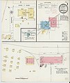
 Sanborn Fire Insurance Map from Barnesville, Lamar County, Georgia. LOC sanborn01382 004-2.tif 6,450 × 7,650; 141.17 MB
-

-
 Sanborn Fire Insurance Map from Barnesville, Lamar County, Georgia. LOC sanborn01382 004-3.tif 6,450 × 7,650; 141.17 MB
-
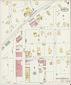
 Sanborn Fire Insurance Map from Boston, Thomas County, Georgia. LOC sanborn01387 001.jpg 6,450 × 7,650; 3.24 MB
-
 Sanborn Fire Insurance Map from Boston, Thomas County, Georgia. LOC sanborn01387 001.tif 6,450 × 7,650; 141.17 MB
-
-
 Sanborn Fire Insurance Map from Greenville, Meriweather County, Georgia. LOC sanborn01444 001.tif 6,450 × 7,650; 141.17 MB
-
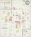
 Sanborn Fire Insurance Map from Hogansville, Troup County, Georgia. LOC sanborn01451 001.jpg 6,450 × 7,650; 3.25 MB
-
 Sanborn Fire Insurance Map from Hogansville, Troup County, Georgia. LOC sanborn01451 001.tif 6,450 × 7,650; 141.17 MB


