Category:1898 maps of Massachusetts
States of the United States: Alaska · California · Connecticut · Florida · Georgia · Illinois · Indiana · Iowa · Kentucky · Louisiana · Maine · Maryland · Massachusetts · Michigan · Minnesota · Mississippi · Missouri · Montana · New Hampshire · New Jersey · New Mexico · New York · North Carolina · North Dakota · Ohio · Oklahoma · Oregon · Pennsylvania · Rhode Island · South Carolina · South Dakota · Tennessee · Texas · Vermont · Virginia · Washington · West Virginia · Wisconsin – Washington, D.C.
Puerto Rico
Puerto Rico
| ← 1890 1891 1892 1893 1894 1895 1896 1897 1898 1899 → |
Subcategories
This category has the following 2 subcategories, out of 2 total.
B
Media in category "1898 maps of Massachusetts"
The following 12 files are in this category, out of 12 total.
-
-

-

-
-
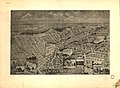
 Annual report of the Massachusetts Highway Commission (1898) (14775848473).jpg 3,420 × 2,202; 1.38 MB
-

-
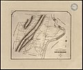
 East Walpole, Norfolk County, Mass. 1898. LOC 75694569.jpg 7,088 × 4,848; 5.02 MB
-
 East Walpole, Norfolk County, Mass. 1898. LOC 75694569.tif 7,088 × 4,848; 98.31 MB
-
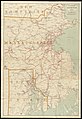
 Electric railway map of eastern New England. LOC 98688386.jpg 7,089 × 10,516; 12.27 MB
-
 Electric railway map of eastern New England. LOC 98688386.tif 7,089 × 10,516; 213.28 MB
-
-
 Winchester, Massachusetts 1898. LOC 75694610.jpg 9,440 × 6,928; 8.16 MB


%27_(11153982735).jpg)
_(14775848473).jpg)


.jpg)
