Category:2016 maps of Germany
Countries of Europe: Bulgaria · Germany · Italy · Kazakhstan‡ · Norway · Romania · Russia‡ · Spain‡ · Sweden · Switzerland · Turkey‡ · Ukraine · United Kingdom
‡: partly located in Europe
‡: partly located in Europe
Federal states of Germany:
Subcategories
This category has the following 8 subcategories, out of 8 total.
'
- 2016 maps of Bavaria (1 F)
- 2016 maps of Hamburg (3 F)
- 2016 maps of Hesse (3 F)
- 2016 maps of Lower Saxony (1 F)
- 2016 maps of Saarland (4 F)
Media in category "2016 maps of Germany"
The following 19 files are in this category, out of 19 total.
-
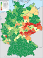
 Bevölkerungsentwicklung abzüglich der Geburtenbilanz 2013-2016.svg 946 × 1,253; 647 KB
-
 Bevölkerungsentwicklung abzüglich der Geburtenbilanz 2015-2016.svg 946 × 1,253; 647 KB
-
 Bevölkerungsentwicklung Kreisebene 2013-2016.svg 946 × 1,253; 704 KB
-
 Bevölkerungsentwicklung Kreisebene 2015-2016.svg 946 × 1,253; 702 KB
-
 BIP je Arbeitsstunde 2016.svg 946 × 1,253; 653 KB
-
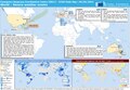
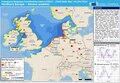 ECDM 20160201 NorthernEurope SevereWeather.pdf 1,625 × 1,125; 572 KB
-
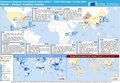
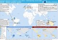 ECDM 20160202 World SevereWeather.pdf 1,625 × 1,125; 567 KB
-
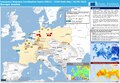
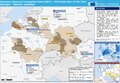 ECDM 20160503 Europe SW V2.pdf 1,625 × 1,125; 658 KB
-
 ECDM 20160530 Europe events.pdf 1,625 × 1,125; 770 KB
-
 ECDM 20160601 World SevereWeather.pdf 1,625 × 1,125; 588 KB
-
 ECDM 20160606 World SevereWeather.pdf 1,625 × 1,125; 578 KB
-
 FDP 2016 neu.png 600 × 710; 108 KB
-
 Geburtenbilanz Kreisebene 2016.svg 946 × 1,253; 647 KB
-
 Geburtenrate Deutschland 2016.svg 946 × 1,253; 647 KB
-
 German states by nominal GRP per capita in 2016.png 4,191 × 4,501; 1.24 MB
-
 Germany map of Köppen climate classification.svg 1,900 × 1,900; 159 KB
-
 Gestorbene Kreisebene 2016.svg 946 × 1,253; 647 KB
-
 FDP Landtage 2016.png 600 × 812; 97 KB
-
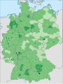
 Spielbanken Deutschland.png 3,915 × 2,400; 4.67 MB


